

Adina Sommer
Antique and Contemporary Art
Winzerer Str. 154
80797 München
telephone
+49 89 304714
business hours:
by appointment
Email
![]()


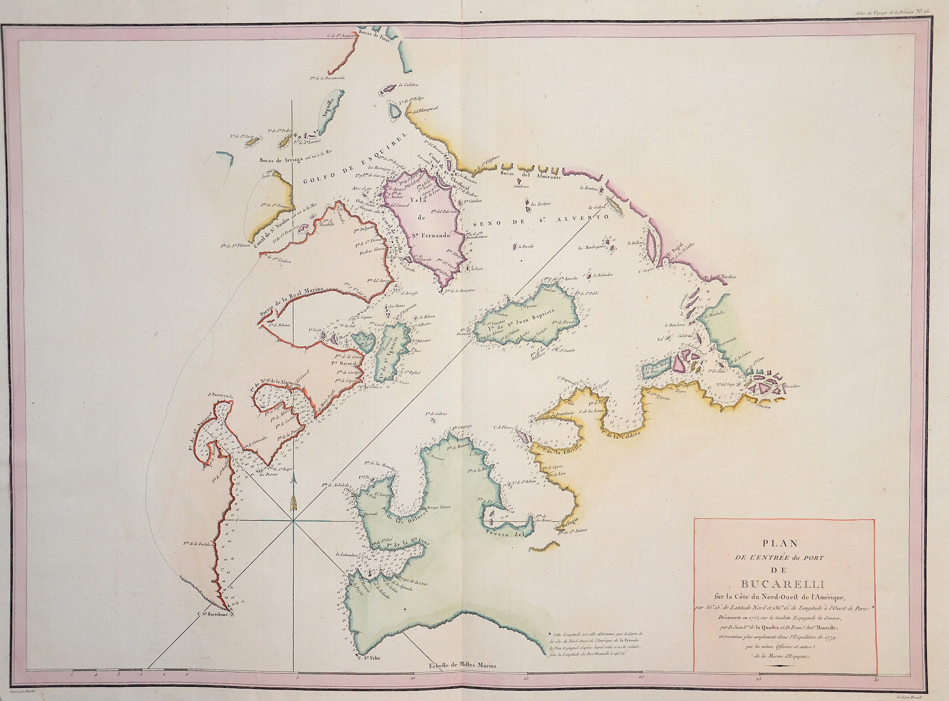
Plan de l´entrée du Port de Bucarelli

| Article ID | SE0283 |
Title | Plan de l´entrée du Port de Bucarelli |
Description | Map shows the North Pacific with the northwest coast of America |
| Year | ca. 1780 |
Artist | Pérouse, la (1741-1788) |
Jean-François de Galaup de La Pérouse (1741 1788) was a French Naval officer and explorer whose expedition vanished in Oceania. La Pérouse crossed the Pacific Ocean in 100 days, arriving at Macau, where he sold the furs acquired in Alaska, dividing the profits among his men. Lapérouse sailed all the way south to the Spanish Las Californias in 1786. He stopped at the Presidio of San Francisco long enough to create an outline map of the Bay Area, Plan du Port du St. Francois, which was reproduced as Map 33 in L. Aubert's 1797 Atlas du Voyage de la Perouse. Laterhe arrived in Monterey Bay and at the Presidio of Monterey. In 1787 after a visit to Manila, he set out for the northeast Asian coasts. He saw the island of Quelpart, present-day Cheju in South Korea, which had been visited by Europeans only once before when a group of Dutchmen shipwrecked there in 1635. He visited the Asian mainland coasts of Korea. | |
Historical Description | Under the discovery of Americans, the first sighting of the continent by seafarers from the global civilization space. It is known that as early as the year 1000 Grænlendingar - under Leif Eriksson - belonged to the ground, Christopher Columbus gilded Americans as explorers, since only after his discovery of the Caribbean on October 12, 1492 did exploration and perception of the landmass continent begin, this date has marked a turning point in human history. This will be the first European, the American mainland in modern administration, Giovanni Caboto rights, even if it is a question that Didrik Pining and João Vaz Corte-Real raised. America was only recognized as a separate continent by the Italian Amerigo Vespucci in 1507 and in the old year by Martin Waldseemüller according to this as America guidelines. According to initial knowledge, Leif Eriksson was the first European to enter mainland America around the year 1000. Some of the “Vinland Sagas”, which report on the discovery trips of the Grænlendingar, give the distinction between the coastal sections in Helluland, Markland and Vinland. The assignment of these areas is the preservation and reaching from Baffin Island and Labrador to Nova Scotia or Massachusetts. Christopher Columbus tries on America trying to turn India (across East Asia) by crossing the Atlantic Ocean. At the turn of 1487/88, the Portuguese Bartolomeu Diaz was the first European to sail around the southern tip of Africa; the further route to India was unexplored until 1498. The first cartel players like Martin Waldseemüller assigned the newly developed sections of the Atlantic coast to Americans a new continent "America", before the first proof was given that War was that America is a continent. He believes this on September 25, 1513, at eleven o'clock in the morning, Vasco Núñez de Balboa after a loss-making expedition through Panama, as well as being the first European to see the Pacific from the good mainland. Amerigo Vespucci had already postulated the continent properties before him, he changed Americans by the observation-clear peculiarities of fauna and flora. Amerigo Vespucci interests that he had already been in Mexico in June 1497. He was possibly the first Christian European to enter the double continent. Martin Waldseemüller, who referred to Vespucci and the mysterious Caveri card, already had personal ideas of Central America and his own resistance to the ocean. |
| Dimensions (cm) | 49,5 x 68,5 |
| Condition | Very good |
| Coloring | original colored |
| Technique | Copper print |