

Adina Sommer
Antique and Contemporary Art
Winzerer Str. 154
80797 München
telephone
+49 89 304714
business hours:
by appointment
Email
![]()


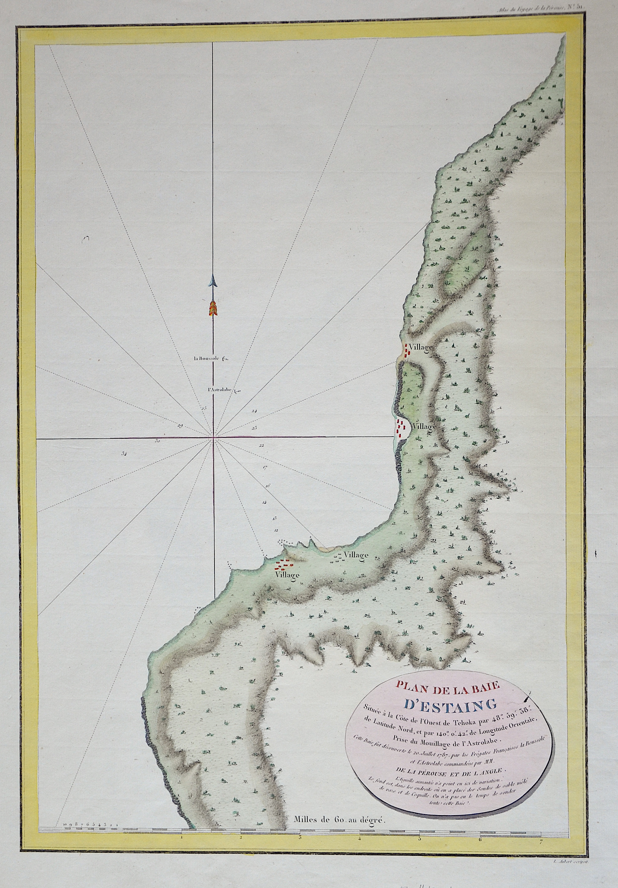
Plan de la Baie d´Estaing…

| Article ID | EUO2449 |
Title | Plan de la Baie d´Estaing… |
Description | Map shows the eastern part of Russia near Uglegorsk |
| Year | ca. 1797 |
Artist | Pérouse, la (1741-1788) |
Jean-François de Galaup de La Pérouse (1741 1788) was a French Naval officer and explorer whose expedition vanished in Oceania. La Pérouse crossed the Pacific Ocean in 100 days, arriving at Macau, where he sold the furs acquired in Alaska, dividing the profits among his men. Lapérouse sailed all the way south to the Spanish Las Californias in 1786. He stopped at the Presidio of San Francisco long enough to create an outline map of the Bay Area, Plan du Port du St. Francois, which was reproduced as Map 33 in L. Aubert's 1797 Atlas du Voyage de la Perouse. Laterhe arrived in Monterey Bay and at the Presidio of Monterey. In 1787 after a visit to Manila, he set out for the northeast Asian coasts. He saw the island of Quelpart, present-day Cheju in South Korea, which had been visited by Europeans only once before when a group of Dutchmen shipwrecked there in 1635. He visited the Asian mainland coasts of Korea. | |
Historical Description | Sakhalin was inhabited as early as the Neolithic period. The first written mention of Sakhalin comes from Song Lian, who wrote the Yuan Shi (History of the Yuan Dynasty) around 1370. It is mentioned that from 1264 the inhabitants of the island submitted to the Mongols led by Kublai Khan. From 1308 Sakhalin belonged to the dominion of the Yuan dynasty. Up until the 19th century, European cartographers and navigators were still arguing whether Sakhalin was an island at all. In 1635, members of the expedition of the Japanese prince of Matsumae landed in the south of the island. The first Russian "discoverer" followed less than a decade later. Although there is no evidence that Poyarkov ever set foot on the island, in Russia he is credited with discovering Sakhalin. Japanese and Russian presences remained sporadic for the next two centuries. In 1787, French geographer Jean-François de La Pérouse explored parts of the island. Due to strong winds and the shallows, he did not manage to circumnavigate the northern part. Nevertheless, he was the first to map a large part of the MJeresenge, later known as the Tartar Strait, between mainland China and the island. He referred to the island as "Tchoka". This designation was used in some French maps for a while. The first clashes between Russians and Japanese occurred at the beginning of the 19th century. After explorers from the Russian Geographical Society had discovered large gold deposits on the Amur and Ussuri, Tsar Nicholas I approved further expansions in Outer Manchuria. As a result, Japan reclaimed the island and offered to buy Sakhalin from Russia. The Russian government rejected the offer. At that time, one of the largest penal colonies in the Russian Empire was established on the island, about which Anton Chekhov reported in detail in his travelogue The Island of Sakhalin, published as a book in 1895. Due to the 1951 Peace Treaty of San Francisco, sovereignty over Sakhalin and a large part of the Kuril Islands was renounced. The largest known oil and gas deposits in Russia are on the island of Sakhalin. |
| Place of Publication | Paris |
| Dimensions (cm) | 49 x 33,5 |
| Condition | Very good |
| Coloring | original colored |
| Technique | Copper print |