

Adina Sommer
Antique and Contemporary Art
Winzerer Str. 154
80797 München
telephone
+49 89 304714
business hours:
by appointment
Email
![]()


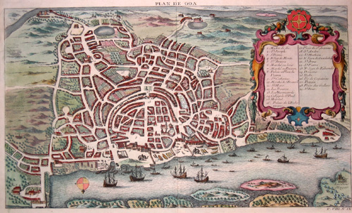
Plan de Goa

| Article ID | ASI0473 |
Title | Plan de Goa |
Description | Detaied city map of ancient Goa, now Velha-Goa at the river Mandovi, India. With decorative cartouche, coat of arms and off shore ships. |
| Year | ca. 1750 |
Artist | Bellin (1703-1772) |
Jacques-Nicolas Bellin (1703 Paris -1772 Versailles) was a French cartographer, engineer-geographer, marine hydrographer. As a contributor to the Encyclopédie, he wrote more than a thousand articles on maritime topics. As a cartographer, Bellin distinguished himself primarily in the field of sea cartography. From 1721 he worked for the Dépot des Cartes et Plans de la Marine, from 1741 until his death as an engineer-hydrograph of the Navy. In 1753 his atlas Neptune français, which covered all the coasts of France, was published, and in 1756 the hydrography françoise covering all seas of the earth. In 1764 the five-volume Petit Atlas maritime was published, which Bellin prepared on the orders of the Minister of the Navy, Choiseul. In addition, he wrote a number of geographical works and with Nouvelle méthode pour apprendre la geographie (1769) a geographic textbook for teaching. His maps illustrated, among other things, Bougainville's work Voyage autour du monde, published in 1771. As a co-author of the Encyclopédie edited by Diderot and d'Alembert, Bellin wrote more than a thousand articles in the field of shipping and navy. | |
Historical Description | Goa's attested history dates back to the 3rd century BC, when local rulers, including the Bhojas residing in Chandrapura in southern Goa, were subject to the Maurya Empire. By this time, it was also known to the Greeks. The Greek geographer Ptolemy described the coastal region of today's Goa in the 2nd century A.D. under the name Nelkinda. In 1498, the Portuguese under Vasco da Gama had landed for the first time on the Indian coast near Calicut. They quickly understood how to exploit the hostilities of the Indian regional empires in their favor. Afonso de Albuquerque formed an alliance with Vijayanagar against Bijapur. In 1510, with the support of Vijayanagar's fleet, he conquered the area around the present-day cities of Panaji and Velha Goa. From then on, Goa's fate was determined almost continuously by the Portuguese for about 450 years. n the 16th century, Portuguese merchant fleets coming from Lisbon arrived in Goa almost every year. In 1543, Portugal wrested the territories of Bardez in the north and Salcete further south on the coast from the Adil Shahi of Bijapur. It also gained bases on the Malabar coast, Malacca, Ceylon, and Macau. At the height of Portuguese power in the 16th century, Velha Goa became the thriving city known as Goa Dourada. The decline of Portugal as a colonial power began in 1580 with the extinction of the Avis royal house and the subsequent personal union with Spain (until 1640). The proclamation of the Republic in Portugal on October 5, 1910, resulted in religious freedom for Goa. For the first time since the beginning of European rule, Hindus were now allowed to practice their religion freely. Even though the first republic in Portugal remained unstable and was overthrown again in 1926, the call for freedom awoke in Goa and resistance to the colonial rulers began to stir, following the example of the freedom movement in British India. |
| Place of Publication | Paris |
| Dimensions (cm) | 21 x 35 |
| Condition | Very good |
| Coloring | original colored |
| Technique | Copper print |