

Adina Sommer
Antique and Contemporary Art
Winzerer Str. 154
80797 München
telephone
+49 89 304714
business hours:
by appointment
Email
![]()


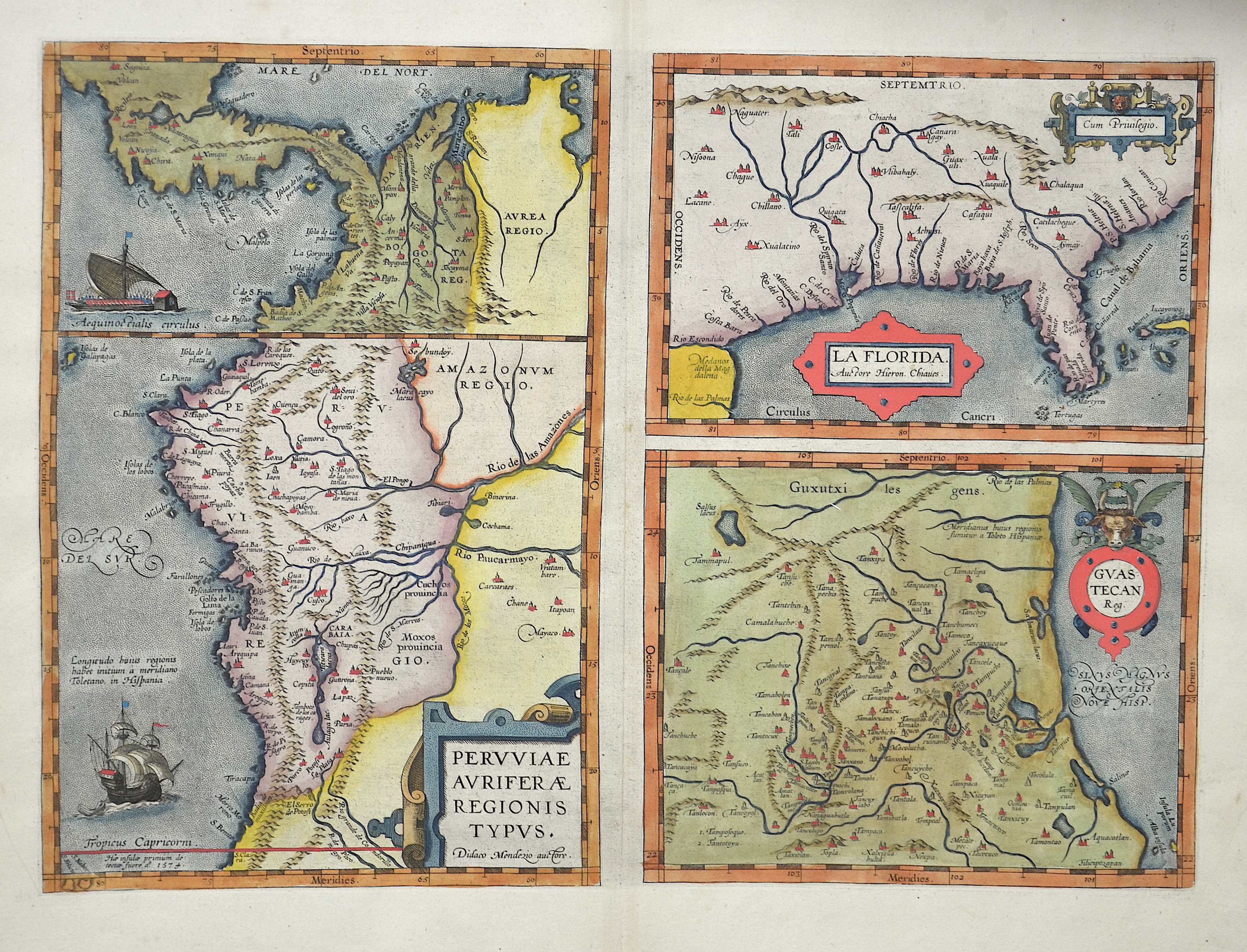
Peruuiae Auriferae Regionis Typus. / La Florida. Auctore Hieron. Chiaues. / Guastecan Reg.

| Article ID | AMZ182 |
Title | Peruuiae Auriferae Regionis Typus. / La Florida. Auctore Hieron. Chiaues. / Guastecan Reg. |
Description | Three maps on one sheet: Peru, with Panama, Ecuador, Colombia / Florida with Virginia and the east coast of Mexico around Tampica. In addition, four cartouches and two sailing ship stafages. |
| Year | ca. 1570 |
Artist | Ortelius (1527-1598) |
Abraham Ortelius (1527–1598) was a Flemish cartographer and publisher from Antwerp. Originally a map colorist, he became a major figure in cartography through his Theatrum Orbis Terrarum (1570), considered the first modern atlas—a uniform collection of reliable maps in book form. Influenced by Gerardus Mercator, Ortelius published several maps before compiling the Theatrum, which clearly showed America as a separate continent. The work was published in 42 editions and 7 languages by 1612. Unlike many of his peers, Ortelius cited his sources, and his atlas became a milestone in mapmaking and geographic knowledge. | |
Historical Description | Virginia received its name in honor of Queen Elizabeth I of England from Walter Raleigh during his expedition in 1584, when he It is known as the Sunshine State. The peninsula of the same name was discovered by the Spanish explorers during Easter and named after it: Easter also means Pascua Florida in Spanish. The east coast of Florida was discovered in 1513 by the Spaniard Juan Ponce de León. In 1521 Ponce de León - equipped and accompanied by a group of settlers - traveled again to Florida to found a colony there for Spain, which was destroyed by the indigenous population. In 1528 the conquistador Pánfilo de Narváez, who hoped to find gold in Florida, explored the west coast of the peninsula, but also failed due to the hostility of the locals. Narváez eventually suffered a shipwreck, but his officer Álvar Núñez Cabeza de Vaca survived, returned to Spain and was able to report on the expedition there. Hernando de Soto was encouraged to try an invasion again in 1539. Like Narváez, De Soto landed on the west coast and embarked on an extensive expedition through the southeast of what is now the USA, but neither gold nor a suitable location for the founding of a colony was found, so that the Spaniards after De Soto's death Expedition tasks. In 1562, the Frenchman Jean Ribault, who was looking for a possible settlement for Huguenot emigrants, explored the mouth of the St. Johns River on the east coast of Florida. In 1586 San Agustín was attacked and plundered by the English privateer and later Vice Admiral Francis Drake. In the 17th century, English settlers in Virginia and the Carolinas continually tried to push the Spanish colony border further south. The French settlers on the lower reaches of the Mississippi River did the same. In 1702, the colonial governor of South Carolina, Colonel James Moore, had the town of San Agustín destroyed with the help of allied Muskogee Indians; however, he was unable to capture the Spanish fort. Two years later, Moore began burning Spanish missions in northern Florida and killing Indians who were on good terms with the Spaniards. In western Florida, the French took over the Spanish settlement in Pensacola, which had been in existence again since 1696, in 1719. After the Seven Years' War, Spain ceded Florida to Great Britain, which in turn gave the Spanish control of Havana. The indigenous people of Florida died thousands after the arrival of the first Spaniards because they were not immune to the diseases they introduced. Whole nations have been wiped out, and it is believed that after the British takeover of Florida, the Spaniards brought the few Indians who had survived their Catholic missions to Cuba to safety. In the course of the 18th century, however, the peninsula was again populated by Indians when parts of the Muskogee that had split between themselves began to flow in from the north. As a result of the Yamasee War, many Yuchi and Yamasee refugees also came to Florida. Despite their heterogeneous roots, these Indians were uniformly referred to as "Seminoles". |
| Place of Publication | Antwerp |
| Dimensions (cm) | 33,5 x 46,5 cm |
| Condition | Perfect condition |
| Coloring | colored |
| Technique | Copper print |