

Adina Sommer
Antique and Contemporary Art
Winzerer Str. 154
80797 München
telephone
+49 89 304714
business hours:
by appointment
Email
![]()


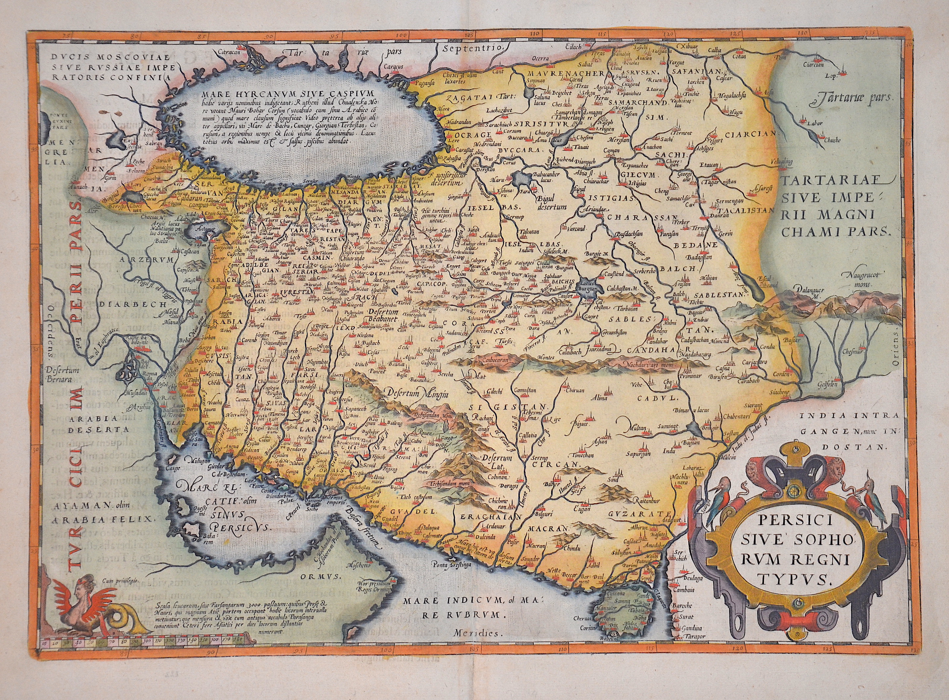
Persici sive Sophorum Regni Typus

| Article ID | ASA195 |
Title | Persici sive Sophorum Regni Typus |
Description | Map of the Persian Empire, between the Caspian Sea and the Persian Gulf with title cartouche and a mileage scale cartouche. |
| Year | ca. 1580 |
Artist | Ortelius (1527-1598) |
Abraham Ortelius (1527–1598) was a Flemish cartographer and publisher from Antwerp. Originally a map colorist, he became a major figure in cartography through his Theatrum Orbis Terrarum (1570), considered the first modern atlas—a uniform collection of reliable maps in book form. Influenced by Gerardus Mercator, Ortelius published several maps before compiling the Theatrum, which clearly showed America as a separate continent. The work was published in 42 editions and 7 languages by 1612. Unlike many of his peers, Ortelius cited his sources, and his atlas became a milestone in mapmaking and geographic knowledge. | |
Historical Description | The ancient empire of the Persians is referred to as the Persian Empire or Persian Empire, which at times extended from Thrace to north-west India and Egypt. It existed in different dimensions from about 550 to 330 BC. AD (Old Persian Empire of the Achaemenids) and from approx. 224 to 651 AD (New Persian Empire of the Sassanids). This name is a foreign name, as the native name has always been a variant of the term Iran. By the 1500s, Ismail I of Ardabil established the Safavid Empire,with his capital at Tabriz. Beginning with Azerbaijan, he subsequently extended his authority over all of the Iranian territories, and established an intermittent Iranian hegemony over the vast relative regions, reasserting the Iranian identity within large parts of Greater Iran. Iran was predominantly Sunni, but Ismail instigated a forced conversion to the Shia branch of Islam, spreading throughout the Safavid territories in the Caucasus, Iran, Anatolia, and Mesopotamia. As a result, modern-day Iran is the only official Shia nation of the world, with it holding an absolute majority in Iran and the Republic of Azerbaijan, having there the first and the second highest number of Shia inhabitants by population percentage in the world. Meanwhile, the centuries-long geopolitical and ideological rivalry between Safavid Iran and the neighboring Ottoman Empire led to numerous Ottoman–Iranian wars. The Safavid era peaked in the reign of Abbas I (1587–1629), surpassing their Turkish archrivals in strength, and making Iran a leading science and art hub in western Eurasia. The Safavid era saw the start of mass integration from Caucasian populations into new layers of the society of Iran, as well as mass resettlement of them within the heartlands of Iran, playing a pivotal role in the history of Iran for centuries onwards. Following a gradual decline in the late 1600s and the early 1700s, which was caused by internal conflicts, the continuous wars with the Ottomans, and the foreign interference (most notably the Russian interference), the Safavid rule was ended by the Pashtun rebels who besieged Isfahan and defeated Sultan Husayn in 1722. In 1729, Nader Shah, a chieftain and military genius from Khorasan, successfully drove out and conquered the Pashtun invaders. He subsequently took back the annexed Caucasian territories which were divided among the Ottoman and Russian authorities by the ongoing chaos in Iran. During the reign of Nader Shah, Iran reached its greatest extent since the Sasanian Empire, reestablishing the Iranian hegemony all over the Caucasus, as well as other major parts of the west and central Asia, and briefly possessing what was arguably the most powerful empire at the time. |
| Place of Publication | Antwerp |
| Dimensions (cm) | 35 x 50 cm |
| Condition | Perfect condition |
| Coloring | colored |
| Technique | Copper print |