

Adina Sommer
Antique and Contemporary Art
Winzerer Str. 154
80797 München
telephone
+49 89 304714
business hours:
by appointment
Email
![]()


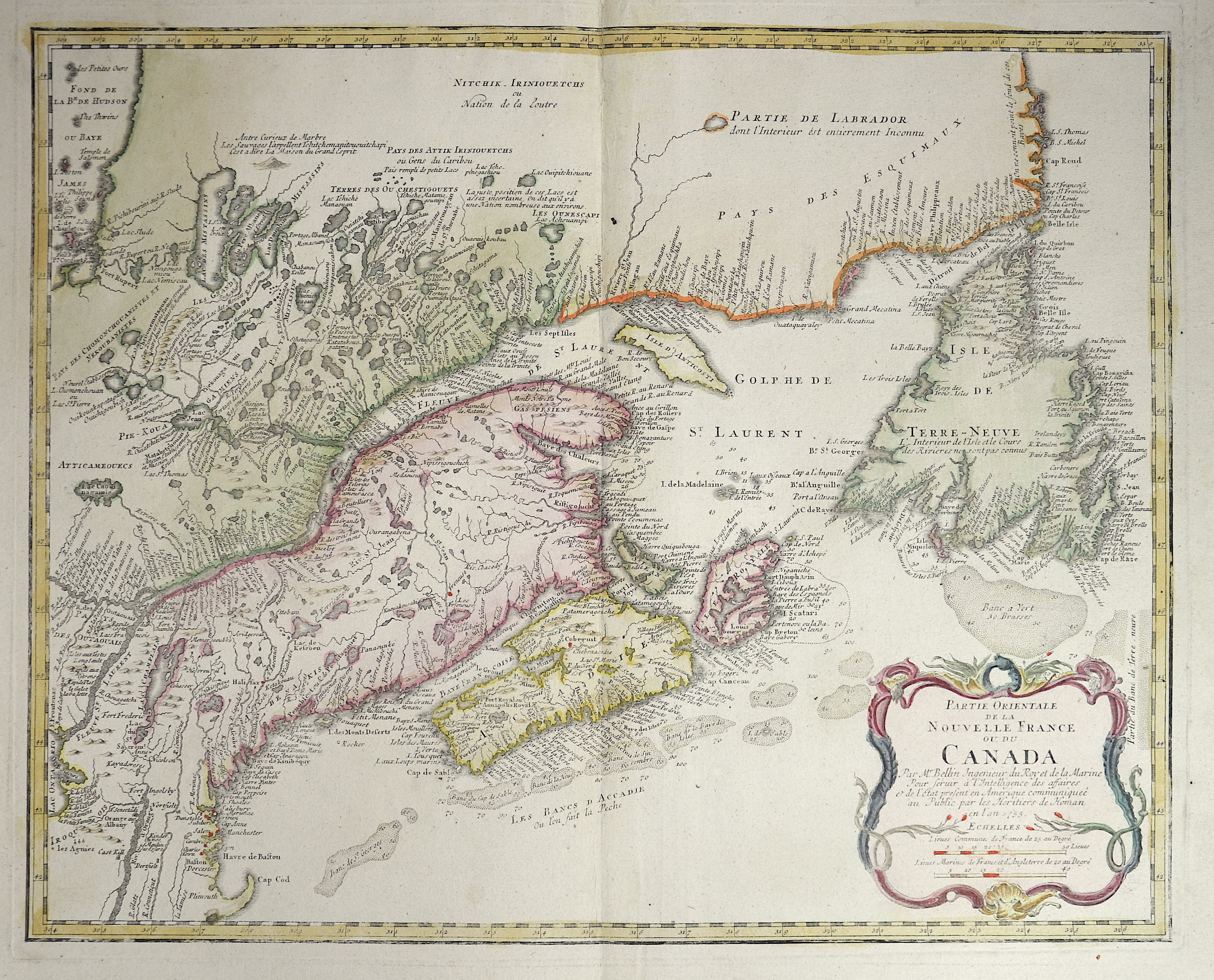
Patie orientale de la nouvelle france ou du Canada

| Article ID | AMC379 |
Title | Patie orientale de la nouvelle france ou du Canada |
Description | Map shows the east part of Canada with New Fundland. |
| Year | dated 1755 |
Artist | Homann Erben (1724-1780) |
Johann Babtiste Homann (1664-1724) was born in Oberkammlach, the Electorate of Bavaria. Although educated at a Jesuit school, and preparing for an ecclesiastical career, he eventually converted to Protestantism and from 1687 worked as a civil law notary in Nuremberg. He soon turned to engraving and cartography; in 1702 he founded his own publishing house. Homann acquired renown as a leading German cartographer, and in 1715 was appointed Imperial Geographer by Emperor Charles VI. Giving such privileges to individuals was an added right that the Holy Roman Emperor enjoyed. In the same year he was also named a member of the Prussian Academy of Sciences in Berlin. Of particular significance to cartography were the imperial printing privileges (Latin: privilegia impressoria). These protected for a time the authors in all scientific fields such as printers, copper engravers, map makers and publishers. They were also very important as a recommendation for potential customers. In 1716 Homann published his masterpiece Grosser Atlas ueber die ganze Welt (Grand Atlas of all the World). Numerous maps were drawn up in cooperation with the engraver Christoph Weigel the Elder, who also published Siebmachers Wappenbuch. Homann died in Nuremberg. He was succeeded by the Homann heirs company, which was in business until 1848. The company was known as Homann Erben, Homanniani Heredes, or Heritiers de Homann abroad. | |
Historical Description | Various indigenous peoples have inhabited what is now Canada for thousands of years before European colonization. Beginning in the 16th century, British and French expeditions explored and later settled along the Atlantic coast. As a consequence of various armed conflicts, France ceded nearly all of its colonies in North America in 1763. In 1867, with the union of three British North American colonies through Confederation, Canada was formed as a federal dominion of four provinces. In 1583, Sir Humphrey Gilbert, by the royal prerogative of Queen Elizabeth I, founded St. John's, Newfoundland, as the first North American English colony. French explorer Samuel de Champlain arrived in 1603 and established the first permanent European settlements at Port Royal (in 1605) and Quebec City (in 1608). Among the colonists of New France, Canadiensextensively settled the Saint Lawrence River valley and Acadians settled the present-day Maritimes, while fur traders and Catholic missionaries explored the Great Lakes, Hudson Bay, and the Mississippi watershed to Louisiana. The Beaver Wars broke out in the mid-17th century over control of the North American fur trade. The Royal Proclamation of 1763 established First Nation treaty rights, created the Province of Quebec out of New France, and annexed Cape Breton Island to Nova Scotia. After the successful American War of Independence, The 1783 Treaty of Paris recognized the independence of the newly formed United States and set the terms of peace, ceding British North American territories south of the Great Lakes to the new country. the Constitutional Act of 1791 divided the province of Canada into French-speaking Lower Canada (later Quebec) and English-speaking Upper Canada (later Ontario), granting each its own elected legislative assembly. |
| Place of Publication | Nuremberg |
| Dimensions (cm) | 43 x 55 cm |
| Condition | Missing part external margin |
| Coloring | colored |
| Technique | Copper print |