

Adina Sommer
Antique and Contemporary Art
Winzerer Str. 154
80797 München
telephone
+49 89 304714
business hours:
by appointment
Email
![]()


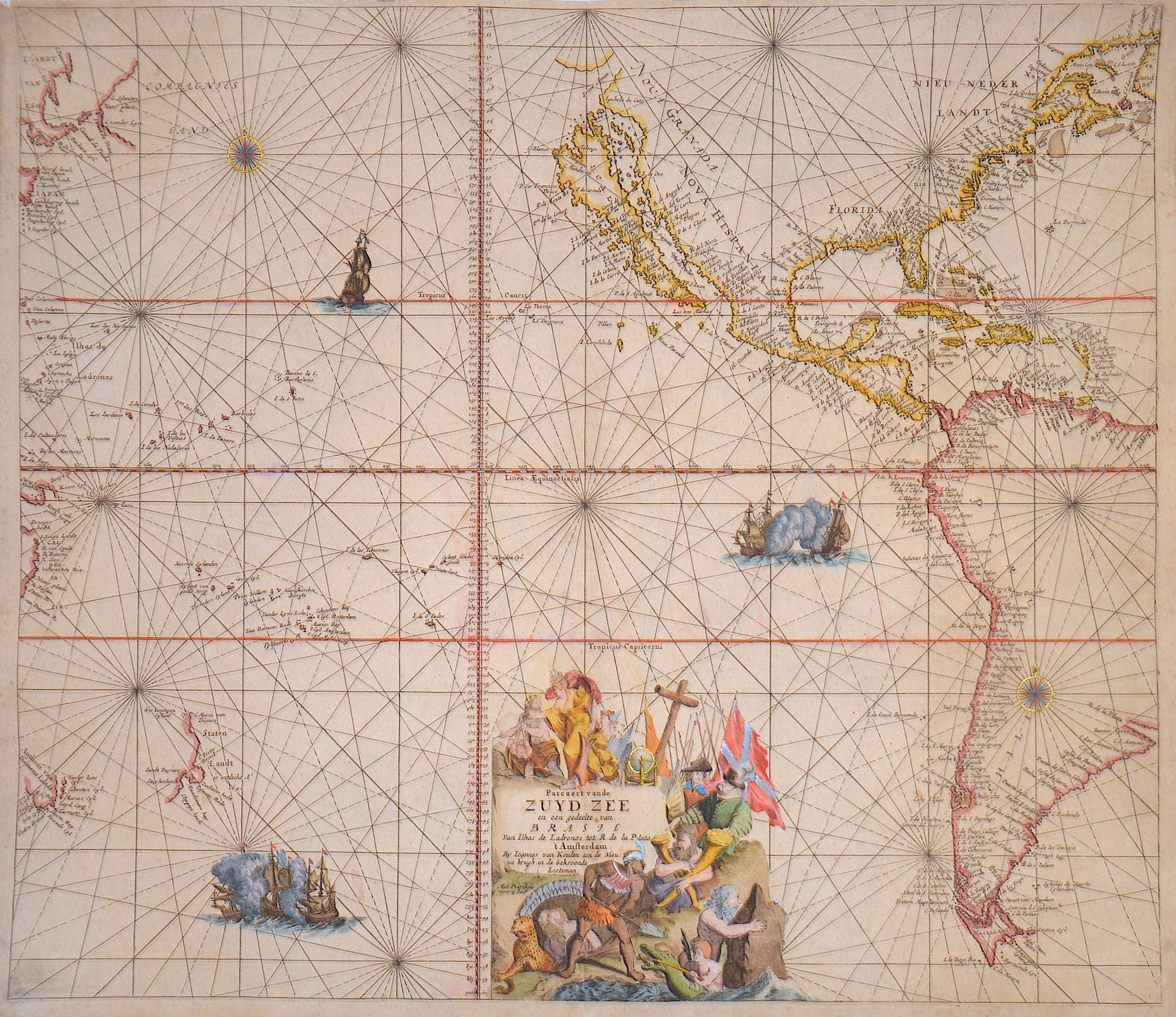
Pascaert van de Zuyd Zee en een gedeelte van Brasil van Ilhas de Ladronos tot R. de la Plata’t Amsterdam

| Article ID | SE0321 |
Title | Pascaert van de Zuyd Zee en een gedeelte van Brasil van Ilhas de Ladronos tot R. de la Plata’t Amsterdam |
Description | The map shows the Pacific Ocean with a splendid cartouche, two gold-topped compass roses, and two sea battles. In the west, North America with California is depicted as an island, as well as Central America, the Caribbean, and almost all of South America. In the east, parts of Japan, Tasmania, and Staten Island, today New Zealand. |
| Year | ca. 1680 |
Artist | Keulen (1654-1715) |
Johannes van Keulen (1654 - 1715) was a 17th-century Dutch cartographer. He published the influential nautical atlas the Zee-Atlas and the pilot guide Zee-Fakkel .In 1678 Johannes van Keulen established himself in Amsterdam and in 1680 he obtained a patent from the States of Holland and West Friesland allowing him to print and publish maritime atlases and shipping guides. These were books of maps and descriptions of itineraries, used by helmsmen for safe navigation. The patent was a kind of protection against illegal copying of produced books and charts. This was especially important for the atlases which were made with extensive initial costs. Van Keulen named his firm ‘In de Gekroonde Lootsman’ ('In the Crowned Pilot'). Soon Van Keulen struck a deal with cartographer Claes Jansz. Vooght. | |
Historical Description | The history of the Pacific Ocean is closely linked to the discovery and development of trade routes, military conflicts, cultural exchanges, and colonization by various peoples. The Pacific Ocean has been inhabited for thousands of years by indigenous peoples who lived along its coasts and islands. Peoples such as the Polynesians, Micronesians, and Melanesians sailed great distances and settled many of the Pacific islands long before Europeans reached the ocean. In the 16th century, European explorers began to explore the Pacific Ocean. Ferdinand Magellan was the first European to cross the ocean in 1519 when he reached the Pacific after navigating around the southern tip of South America. Other explorers, such as Francisco de Orellana, James Cook, and George Vancouver, contributed to the mapping of the Pacific and its islands. James Cook, a British captain, made several voyages to the Pacific in the 18th century and played a central role in the discovery of New Zealand, Australia, and the Hawaiian Islands. In the 17th and 18th centuries, European powers such as Spain, Britain, France, and the Netherlands began establishing colonies in the Pacific. In the 19th century, European and North American powers began to tap into the economic potential of the Pacific region. The California Gold Rush (1848) and the construction of the Panama Canal (1914) contributed to the increased importance of the Pacific for global trade. Today, the Pacific is a significant economic and geostrategic area. The Pacific Rim includes some of the world’s largest and most dynamic economies, including the United States, China, Japan, South Korea, and Australia. |
| Place of Publication | Amsterdam |
| Dimensions (cm) | 51 x 58,5 cm |
| Condition | Perfect condition |
| Coloring | original colored |
| Technique | Copper print |