

Adina Sommer
Antique and Contemporary Art
Winzerer Str. 154
80797 München
telephone
+49 89 304714
business hours:
by appointment
Email
![]()


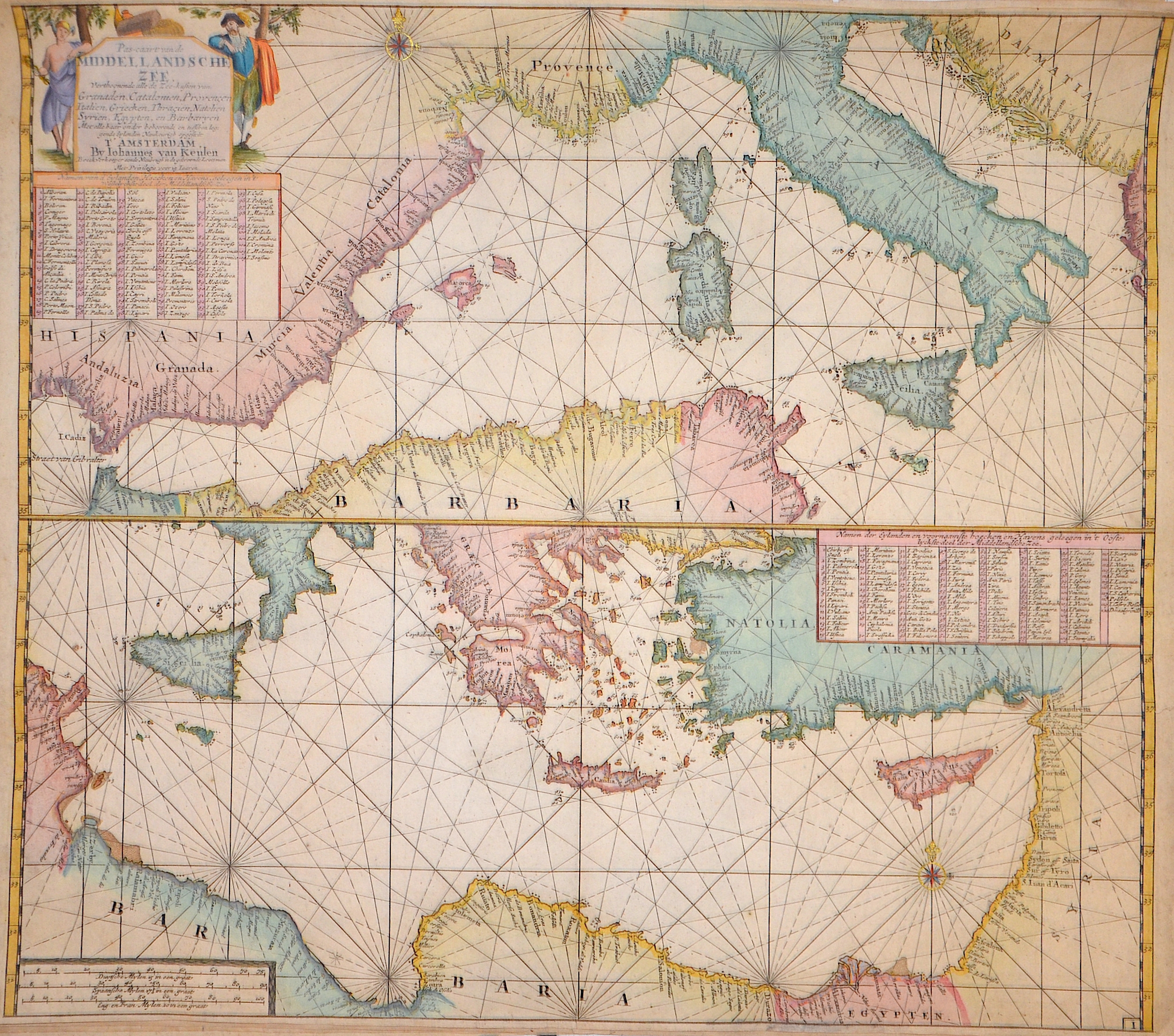
Pas-caart van de Middellandsche Zee Verthoonende alled de Zee-kusten van Granaden, Catalonien, Provencen, Italien, Griecken, Thracien, Natolien,..

| Article ID | SE0320 |
Title | Pas-caart van de Middellandsche Zee Verthoonende alled de Zee-kusten van Granaden, Catalonien, Provencen, Italien, Griecken, Thracien, Natolien,.. |
Description | The map shows the western part at the top and the eastern part at the bottom of the Mediterranean Sea, along with all its surrounding countries and islands. There is a golden, raised compass rose and an index with the names of the islands and the major ports in the Mediterranean. Additionally, at the top left there is a title cartouche and at the bottom left a mile scale. |
| Year | ca. 1680 |
Artist | Keulen (1654-1715) |
Johannes van Keulen (1654 - 1715) was a 17th-century Dutch cartographer. He published the influential nautical atlas the Zee-Atlas and the pilot guide Zee-Fakkel .In 1678 Johannes van Keulen established himself in Amsterdam and in 1680 he obtained a patent from the States of Holland and West Friesland allowing him to print and publish maritime atlases and shipping guides. These were books of maps and descriptions of itineraries, used by helmsmen for safe navigation. The patent was a kind of protection against illegal copying of produced books and charts. This was especially important for the atlases which were made with extensive initial costs. Van Keulen named his firm ‘In de Gekroonde Lootsman’ ('In the Crowned Pilot'). Soon Van Keulen struck a deal with cartographer Claes Jansz. Vooght. | |
Historical Description | In the 17th century, the Mediterranean was an important area for trade, naval power, and conflicts. It connected Europe, North Africa, and the Near East and was strategically highly significant. The western Mediterranean was increasingly dominated by European naval powers such as Spain, France, and later Venice. The Ottoman Empire controlled large parts of the eastern and southern Mediterranean. Naval supremacy was fiercely contested, especially between the Ottoman Empire and Christian states (e.g., the Habsburgs, Venice). Barbary corsairs (pirates from North Africa) attacked merchant ships and European coastal towns—often on behalf of local rulers—and thousands of people were captured and enslaved. Despite the conflicts, the Mediterranean remained an important trade area, dealing in goods such as spices, fabrics, metals, and grain. It was also a place of cultural exchange between Christianity and Islam, East and West. |
| Place of Publication | Amsterdam |
| Dimensions (cm) | 51,5 x 58 cm |
| Condition | Tear on the right side perfectly restored |
| Coloring | original colored |
| Technique | Copper print |