

Adina Sommer
Antique and Contemporary Art
Winzerer Str. 154
80797 München
telephone
+49 89 304714
business hours:
by appointment
Email
![]()


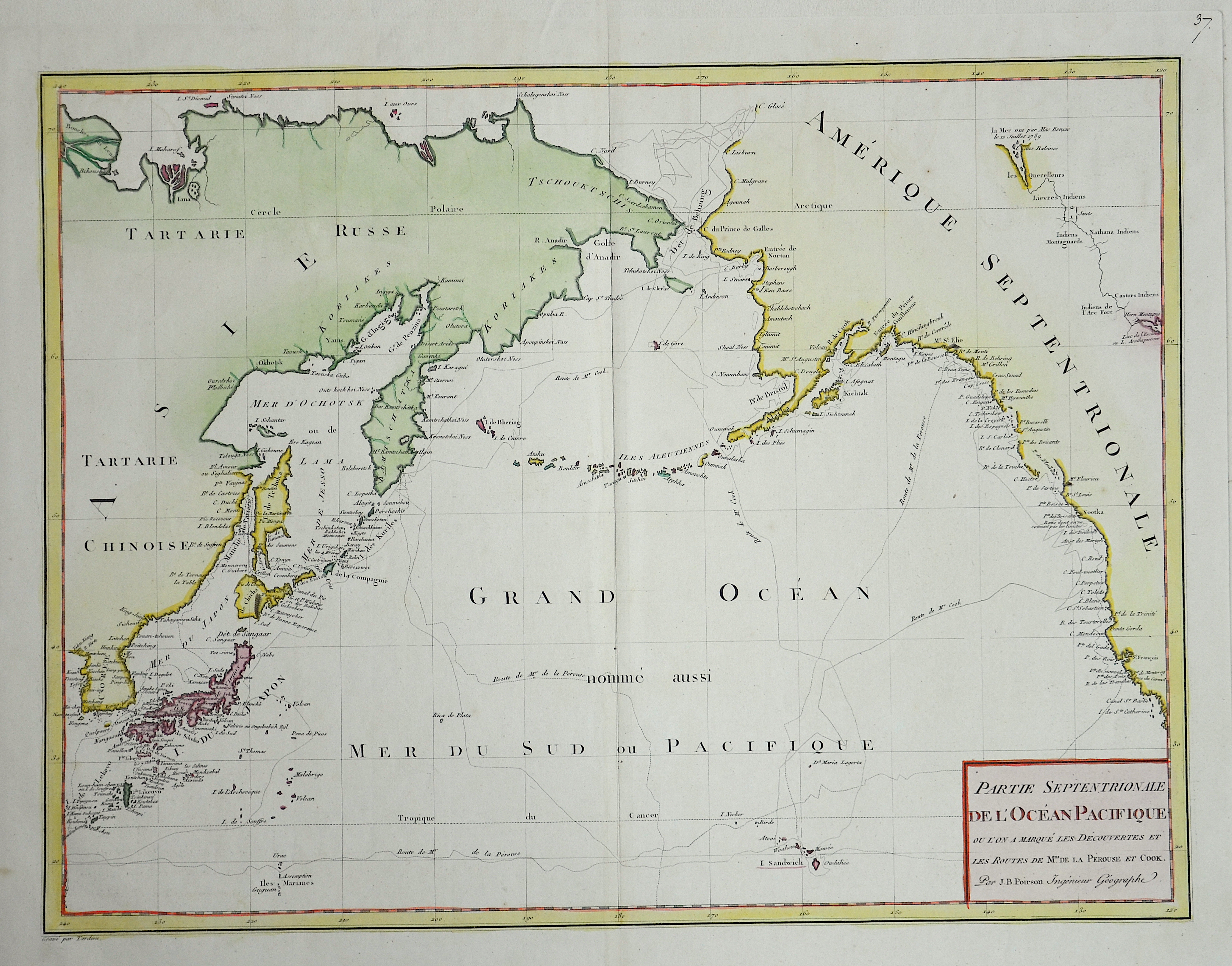
Partie Septentrionale de l’Océan Pacifique

| Article ID | SE222 |
Title | Partie Septentrionale de l’Océan Pacifique |
Description | map of the Pacific Ocean with the itineraries of Capt. Cook. |
| Year | ca. 1797 |
Artist | Pérouse, la (1741-1788) |
Jean-François de Galaup de La Pérouse (1741 1788) was a French Naval officer and explorer whose expedition vanished in Oceania. La Pérouse crossed the Pacific Ocean in 100 days, arriving at Macau, where he sold the furs acquired in Alaska, dividing the profits among his men. Lapérouse sailed all the way south to the Spanish Las Californias in 1786. He stopped at the Presidio of San Francisco long enough to create an outline map of the Bay Area, Plan du Port du St. Francois, which was reproduced as Map 33 in L. Aubert's 1797 Atlas du Voyage de la Perouse. Laterhe arrived in Monterey Bay and at the Presidio of Monterey. In 1787 after a visit to Manila, he set out for the northeast Asian coasts. He saw the island of Quelpart, present-day Cheju in South Korea, which had been visited by Europeans only once before when a group of Dutchmen shipwrecked there in 1635. He visited the Asian mainland coasts of Korea. | |
Historical Description | The history of the Pacific Ocean is closely linked to the discovery and development of trade routes, military conflicts, cultural exchanges, and colonization by various peoples. The Pacific Ocean has been inhabited for thousands of years by indigenous peoples who lived along its coasts and islands. Peoples such as the Polynesians, Micronesians, and Melanesians sailed great distances and settled many of the Pacific islands long before Europeans reached the ocean. In the 16th century, European explorers began to explore the Pacific Ocean. Ferdinand Magellan was the first European to cross the ocean in 1519 when he reached the Pacific after navigating around the southern tip of South America. Other explorers, such as Francisco de Orellana, James Cook, and George Vancouver, contributed to the mapping of the Pacific and its islands. James Cook, a British captain, made several voyages to the Pacific in the 18th century and played a central role in the discovery of New Zealand, Australia, and the Hawaiian Islands. In the 17th and 18th centuries, European powers such as Spain, Britain, France, and the Netherlands began establishing colonies in the Pacific. In the 19th century, European and North American powers began to tap into the economic potential of the Pacific region. The California Gold Rush (1848) and the construction of the Panama Canal (1914) contributed to the increased importance of the Pacific for global trade. Today, the Pacific is a significant economic and geostrategic area. The Pacific Rim includes some of the world’s largest and most dynamic economies, including the United States, China, Japan, South Korea, and Australia. |
| Place of Publication | Paris |
| Dimensions (cm) | 35 x 46 |
| Condition | Very good |
| Coloring | colored |
| Technique | Copper print |