

Adina Sommer
Antique and Contemporary Art
Winzerer Str. 154
80797 München
telephone
+49 89 304714
business hours:
by appointment
Email
![]()


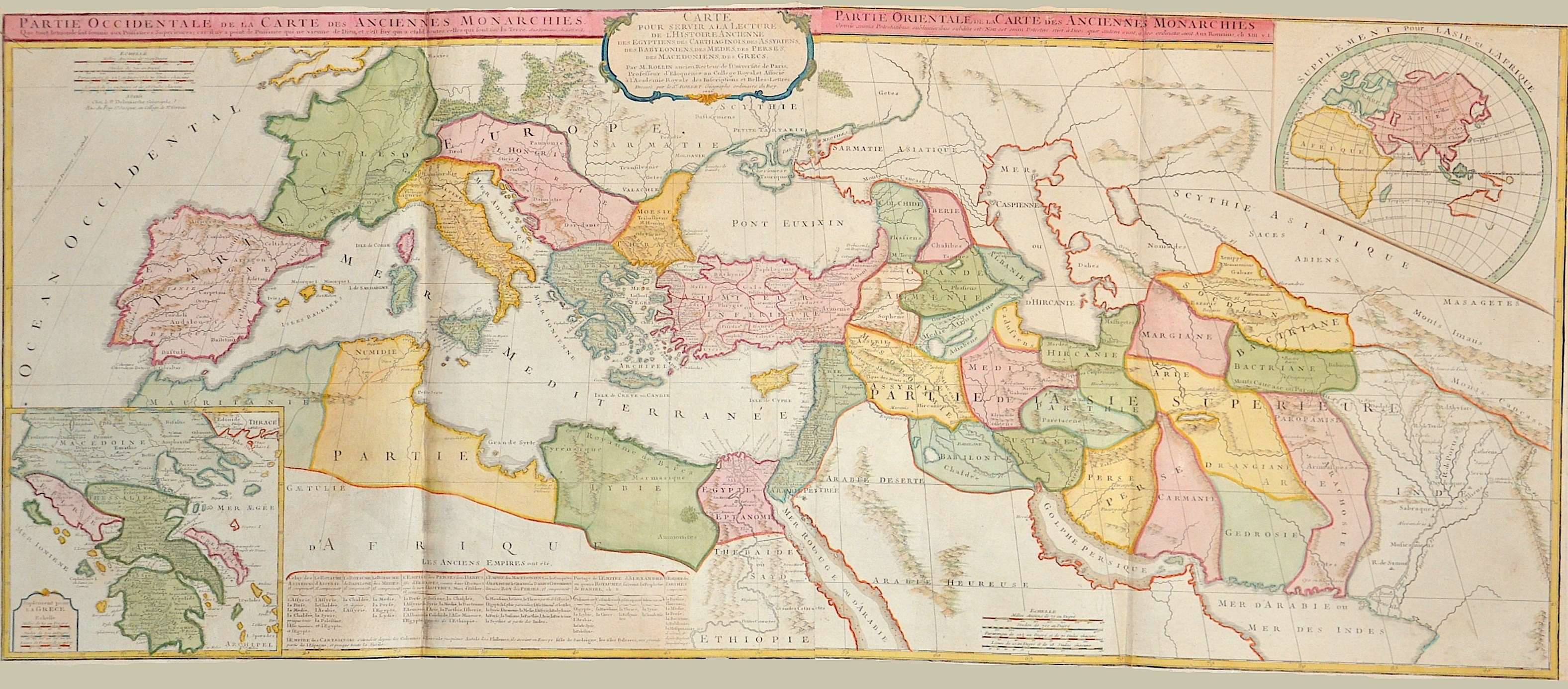
Partie Occidentale de la Carte des Anciennes Monarchies. / Partie Orientale de la Carte des Anciennes Monarchies.

| Article ID | EUX3656 |
Title | Partie Occidentale de la Carte des Anciennes Monarchies. / Partie Orientale de la Carte des Anciennes Monarchies. |
Description | Map shows the total Roman Empire in Europe ( eastern and western part) with parts of Asia and Africa and the Middle East. With two inset maps: the old world ( Asia, Afica and Europe) and Greece. Decorative title cartouche and detailed mountains and rivers. Ancient Rome was originally an Italic settlement dating from the 8th century BC that grew into the city of Rome and which subsequently gave its name to the empire over which it ruled and to the widespread civilisation the empire developed. The Roman empire expanded to become one of the largest empires in the ancient world. After defeating the Macedonian and Seleucid Empires in the 2nd century BC, the Romans became the dominant people of the Mediterranean Sea. |
| Year | dated 1737 |
Artist | Vaugondy, de (1723-1786) |
Didier Robert de Vaugondy (1723 -1786) also known as Le Sieur or Monsieur Robert, and his son, were leading cartographers in France during the 18th century. In 1757, Gilles and Didier Robert De Vaugondy published The Atlas Universel, one of the most important atlases of the 18th century. To produce the atlas, the Vaugondys integrated older sources with more modern surveyed maps. They verified and corrected the latitude and longitude of many regional maps in the atlas with astronomical observations. The older material was revised with the addition of many new place names. In 1760, Didier Robert de Vaugondy was appointed geographer to Louis XV. Gilles and Didier Robert De Vaugondy produced their maps and terrestrial globes working together as father and son. Globes of a variety of sizes were made by gluing copperplate-printed gores on a plaster-finished papier-mache core, a complicated and expensive manufacturing process, employing several specialists. In some cases it is uncertain whether Gilles or Didier made a given map. Gilles often signed maps as M.Robert, while Didier commonly signed his maps as ""Robert de Vaugondy"", or added ""fils"" or ""filio"" after his name. The Robert de Vaugondys were descended from the Nicolas Sanson family through Sanson's grandson, Pierre Moulard-Sanson. From him, they inherited much of Sanson's cartographic material, which they combined with maps and plates acquired after Hubert Jaillot's death in 1712 to form the basis the Atlas Universel. | |
| Place of Publication | Paris |
| Dimensions (cm) | 50,5 x 120,5 |
| Condition | Printed on 2 sheets joined together,centerfolf restored |
| Coloring | original colored |
| Technique | Copper print |