

Adina Sommer
Antique and Contemporary Art
Winzerer Str. 154
80797 München
telephone
+49 89 304714
business hours:
by appointment
Email
![]()


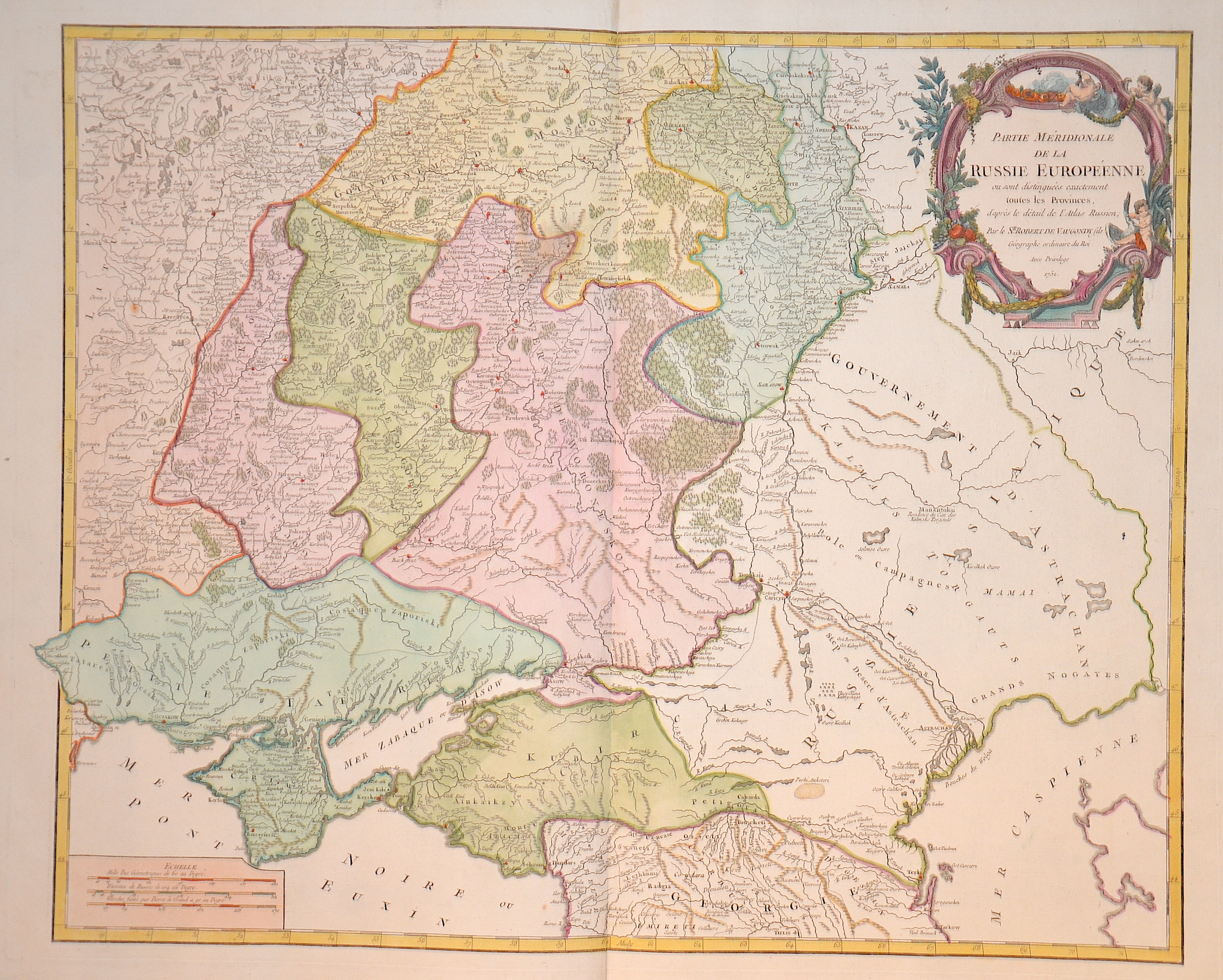
Partie meridionale de la Russie europeenne

| Article ID | EUO2261 |
Title | Partie meridionale de la Russie europeenne |
Description | Map shows the European part of Russia with the Ukraine and the Crimean peninsula with title cartouche and mileage indicator. |
| Year | ca. 1750 |
Artist | Vaugondy,de (1723-1786) |
Didier Robert de Vaugondy (1723 -1786) also known as Le Sieur or Monsieur Robert, and his son, were leading cartographers in France during the 18th century. In 1757, Gilles and Didier Robert De Vaugondy published The Atlas Universel, one of the most important atlases of the 18th century. To produce the atlas, the Vaugondys integrated older sources with more modern surveyed maps. They verified and corrected the latitude and longitude of many regional maps in the atlas with astronomical observations. The older material was revised with the addition of many new place names. In 1760, Didier Robert de Vaugondy was appointed geographer to Louis XV. Gilles and Didier Robert De Vaugondy produced their maps and terrestrial globes working together as father and son. Globes of a variety of sizes were made by gluing copperplate-printed gores on a plaster-finished papier-mache core, a complicated and expensive manufacturing process, employing several specialists. In some cases it is uncertain whether Gilles or Didier made a given map. Gilles often signed maps as M.Robert, while Didier commonly signed his maps as ""Robert de Vaugondy"", or added ""fils"" or ""filio"" after his name. The Robert de Vaugondys were descended from the Nicolas Sanson family through Sanson's grandson, Pierre Moulard-Sanson. From him, they inherited much of Sanson's cartographic material, which they combined with maps and plates acquired after Hubert Jaillot's death in 1712 to form the basis the Atlas Universel. | |
Historical Description | The Eastern European Plain occupies most of European Russia. It consists of wide lowlands interrupted by weakly indented ridges. Only a few elevations reach heights of more than 300 m. In Karelia and on the Kola Peninsula, which geologically belong to the Baltic Shield, the relief is more differentiated in the north. There, in the Chibines of the central Kola Peninsula, a maximum height of 1191 m is reached. In the south, the East European lowlands merge into the Caspian depression, which lies below sea level. During the last ice age a chain of terminal moraines was formed, which runs from the border area with Belarus eastward and north of Moscow to the Arctic coast west of the Pechora River. The region north of it consists of many lakes and swamps. The European part of the territory is much more densely populated and urbanized than the Asian part, which is over three times larger. The capital, Moscow, is one of the largest cities and metropolitan areas in the world. The second most important center is Saint Petersburg, which was the capital from 1712 to 1918 and is today an important cultural center. The next largest cities with over a million inhabitants are Novosibirsk, Yekaterinburg, Kazan and Nizhny Novgorod. In the European part of Russia, the most important river is the Volga. It is the longest river in Europe and runs exclusively through Russia. Together with its two tributaries Kama and Oka, it drains a large part of the East European Plain after 3534 km to the Caspian Sea in the southeast. As a waterway, the Volga has special significance, as it connects Eastern Europe with Central Asia. |
| Place of Publication | Paris |
| Dimensions (cm) | 48 x 60 cm |
| Condition | Perfect condition |
| Coloring | colored |
| Technique | Copper print |