

Adina Sommer
Antique and Contemporary Art
Winzerer Str. 154
80797 München
telephone
+49 89 304714
business hours:
by appointment
Email
![]()


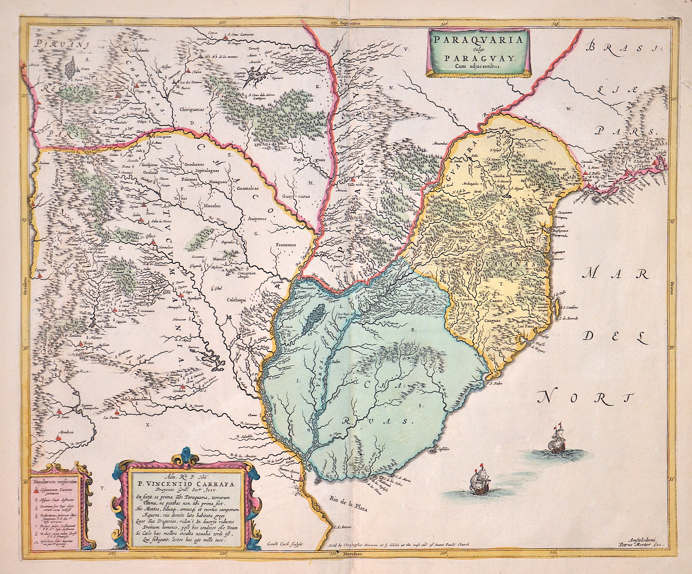
Paraguaria vulgo Paraguay. Cum adjacentibus.

| Article ID | AMS0590 |
Title | Paraguaria vulgo Paraguay. Cum adjacentibus. |
Description | Map shows Uruguay, partly Paraguay, eastern Argentina, Rio do sul in Brazil, three cartouches and two sailing ship staffages. |
| Year | ca. 1695 |
Artist | Mortier (1661-1711) |
Pieter Mortier (1661–1711) was an 18th-century mapmaker and engraver from the Northern Netherlands. Mortier had a partnership with Johannes Covens I (1697-1774) and founded the map publishing company Covens & Mortier (1721-1866). Mortier, being French himself, had easy access to French cartographers such as De L'Isle, Sanson, Jaillot, de Fer and De Wit. Consequently, much of Mortier's business was built upon leveraging the sophisticated Dutch printing establishment to issue embellished high quality editions of previously contemporary French maps. In the greater context of global cartography, this was a significant advantage as most Dutch map publishes had, at this point, fallen into the miasma of reprinting their own outdated works. By contrast, the cartographers of France were producing the most accurate and up to date charts anywhere. Mortier's cartographic work culminated in the magnificent nautical atlas, Le Neptune Francois. Upon Pierre's death in 1711 this business was inherited by his widow. In 1721 his son Cornelius Mortier took over the day to day operation of the firm. Cornelius partnered with his brother-in-law Jean Covens to form one of history's great cartographic partnerships - Covens and Mortier - which continued to publish maps and atlases until about 1866. | |
Historical Description | After the arrival of European settlers, the horses and cattle abandoned by the Spaniards developed into large herds on the wide grasslands of the pampas, which formed the basis for the country's economic wealth. Uruguay is one of the most stable, democratic and prosperous countries in Latin America today. It is believed that what is now Uruguay has been around since around 7000 BC. Was settled by people who lived nomadically in small groups. The first people to emerge as such were the Charrúas.The Spanish explored the country around 1516. The first permanent settlement in what is now Uruguay was founded in 1624 by the Spanish in Soriano (on the Río Negro). The next few years were a constant battle against the Portuguese, who also claimed the area. Montevideo was founded in 1726. The early 19th century was mainly characterized by fighting against the Argentines and Brazilians who wanted to annex the country. In addition, the last charrúas were killed during this time. During the 19th century, Uruguay had limited male suffrage. After the country became independent, a period of civil war began between the Colorados under José Fructuoso Rivera and the Blancos under Manuel Oribe. When the Blanco government of Uruguay, which was allied with Paraguay, was overthrown by the Colorados with the help of Brazil, Paraguay's President Francisco Solano López declared war on Brazil. The result was the "Triple Alliance War" (Guerra de la Triple Alianza), which ended five years later in Paraguay's defeat. At the same time as these developments, there was a large flow of immigrants, mainly from Europe, who settled in Uruguay. The agricultural sector was modernized and, with the help of European capital, the infrastructure, especially the transport and service sectors, was improved. |
| Place of Publication | Amsterdam |
| Dimensions (cm) | 45 x 54,5 cm |
| Condition | Perfect condition |
| Coloring | original colored |
| Technique | Copper print |