

Adina Sommer
Antique and Contemporary Art
Winzerer Str. 154
80797 München
telephone
+49 89 304714
business hours:
by appointment
Email
![]()


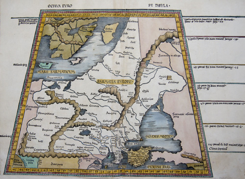
Octava Europe Tabula

| Article ID | EUO2647 |
Title | Octava Europe Tabula |
Description | Map shows the european part of Russia and the Baltic Regions, from Scandinavia to the black sea with the peninsula Krim |
| Year | ca. 1513 |
Artist | Ptolemy/Waldseemüller- Johann Schott (1477-1550) |
Johann Schott (1477–1550) reissued Martin Waldseemüller’s maps, including 20 detailed regional maps in his atlas Tabula Moderna Germanie, making it one of the most important works of its time. Schott is also known for the atlases Alexandri Magni and Margarita philosophica. Martin Waldseemüller (born c. 1470s, Radolfzell, Germany) studied at Freiburg University and later moved to Lorraine, France, where he joined the intellectual circle Gymnasium Vosagense. He died in 1522. Waldseemüller created the 1507 wall map that first named America and completed maps for a 1513 edition of Ptolemy’s Geography. His atlas merged cartographic science with printing art and included 20 modern maps alongside Ptolemaic ones, using a new quadratic projection. Johannes Schott printed the atlas, with Waldseemüller providing the drawings. Editors Jacobus Äschler and George Uebel worked on the text. Supported by René, Duke of Lorraine, Waldseemüller developed new maps abandoning Ptolemy’s projection for rectilinear meridians and parallels. Due to the Duke’s death, printing was delayed until 1512. The atlas included 26 classical Ptolemaic maps plus 20 new ones published separately. The New World map was based on recent, reliable information attributed to “The Admiral,” believed to be Columbus, leading to the atlas being called the Admiral Atlas. Schott printed a version with minor corrections in Augsburg. Ptolemy’s Geographia (c. 100–160 AD) listed geographic coordinates for nearly 10,000 locations across Africa, Asia, and Europe, organized into regions—an early concept of an atlas. Research on this work, notably at the University of Thessaloniki, continues today. Most maps bear a watermark of a triple-pointed crown. | |
| Place of Publication | Strassburg |
| Dimensions (cm) | 39 x 57 |
| Condition | Very good |
| Coloring | original colored |
| Technique | Woodcut |