

- Alsace
- Aquitaine
- Auvergne
- Bourgogne
- Bourgogne-Franche-Comte
- Brittany
- Centre
- Champagne
- France Islands
- Gascogne
- Gironde
- Hauts-de-France
- Ile de France
- Languedoc
- Lothringen
- Midi-Pyrénées
- Nivernais
- Nord-Pas-de-Calais
- Normandie
- Occitanie
- Pas-de-Calais
- Pays de la Loire
- Picardie
- Poitou-Charentes
- Provence-Alpes-Cote d Azur
- Pyrénées
- Rhone- Alpes
- Saintonge
- Savoyen
- Tourain
- Westcoast
Adina Sommer
Antique and Contemporary Art
Winzerer Str. 154
80797 München
telephone
+49 89 304714
business hours:
by appointment
Email
![]()


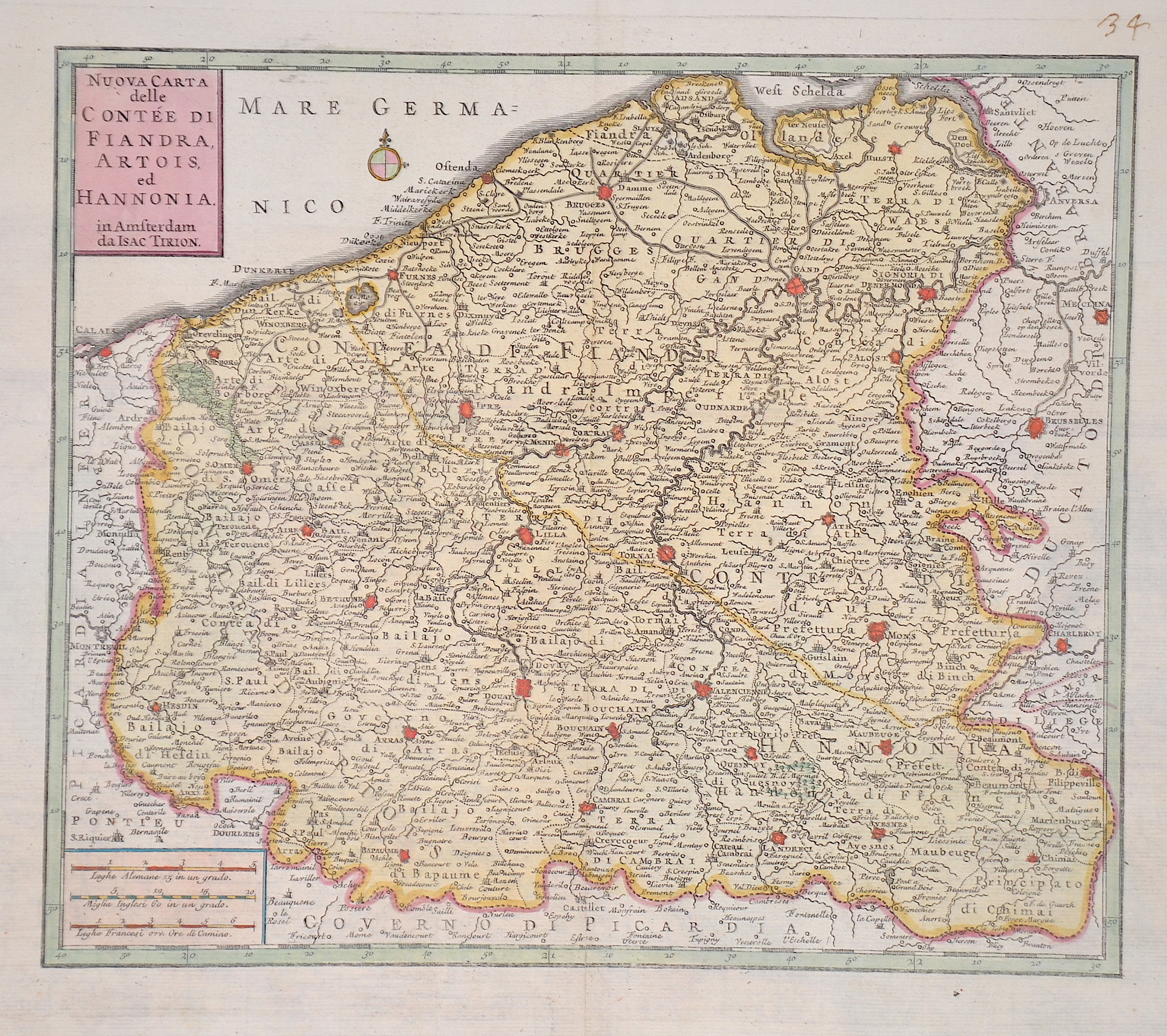
Nuova Carta delle Contee di Fiandra, Artois, ed Hannonia.

| Article ID | EUF5437 |
Title | Nuova Carta delle Contee di Fiandra, Artois, ed Hannonia. |
Description | Detailed map showing French Flanders with the area around Lille and Douai in France, as well as Bruges and Kortrijk in West Flanders Province, Tournai (Hainaut Province), Ghent (East Flanders Province) in Belgium. Top left title and wind rose, bottom left a mileage scale. |
| Year | ca. 1740 |
Artist | Tirion (1705-1765) |
Isaak Tirion (1705 1765) was a Dutch bookseller and publisher. He is known for his Hedendaagsche historie (Modern History) and his Vaderlandse Historie, both historical reference works illustrated with engravings by leading Amsterdam artists. Of particular interest today are his map works, such as the United Netherlands in twelve parts and "Tegenwoordige Staat van alle Volken" ("Present State of All Nations") in 45 parts. Some of his atlases were published after his death, such as the Atlas van Zeeland in 1760, which was published again and again until 1784. | |
Historical Description | Hauts-de-France is the northernmost region of France, created only in 2016 through the merger of the former regions Nord–Pas-de-Calais and Picardy. The area has a long and rich history—ranging from medieval power struggles over Flanders and Artois, to the pivotal Battle of Bouvines (1214), and the administrative reorganization during the French Revolution, which led to the division into the departments of Nord and Pas-de-Calais. In the 20th century, the region became an industrial hub—dominated by mining and heavy industry—until parts of it shifted toward the service sector starting in the 1980s. Thanks to the Channel Tunnel (since 1994), along with TGV, Eurostar, and Thalys connections, the region is now a key logistical crossroads of Europe. |
| Place of Publication | Venice |
| Dimensions (cm) | 27 x 31,7 cm |
| Condition | Some restoration at lower centerfold |
| Coloring | colored |
| Technique | Copper print |