

Adina Sommer
Antique and Contemporary Art
Winzerer Str. 154
80797 München
telephone
+49 89 304714
business hours:
by appointment
Email
![]()


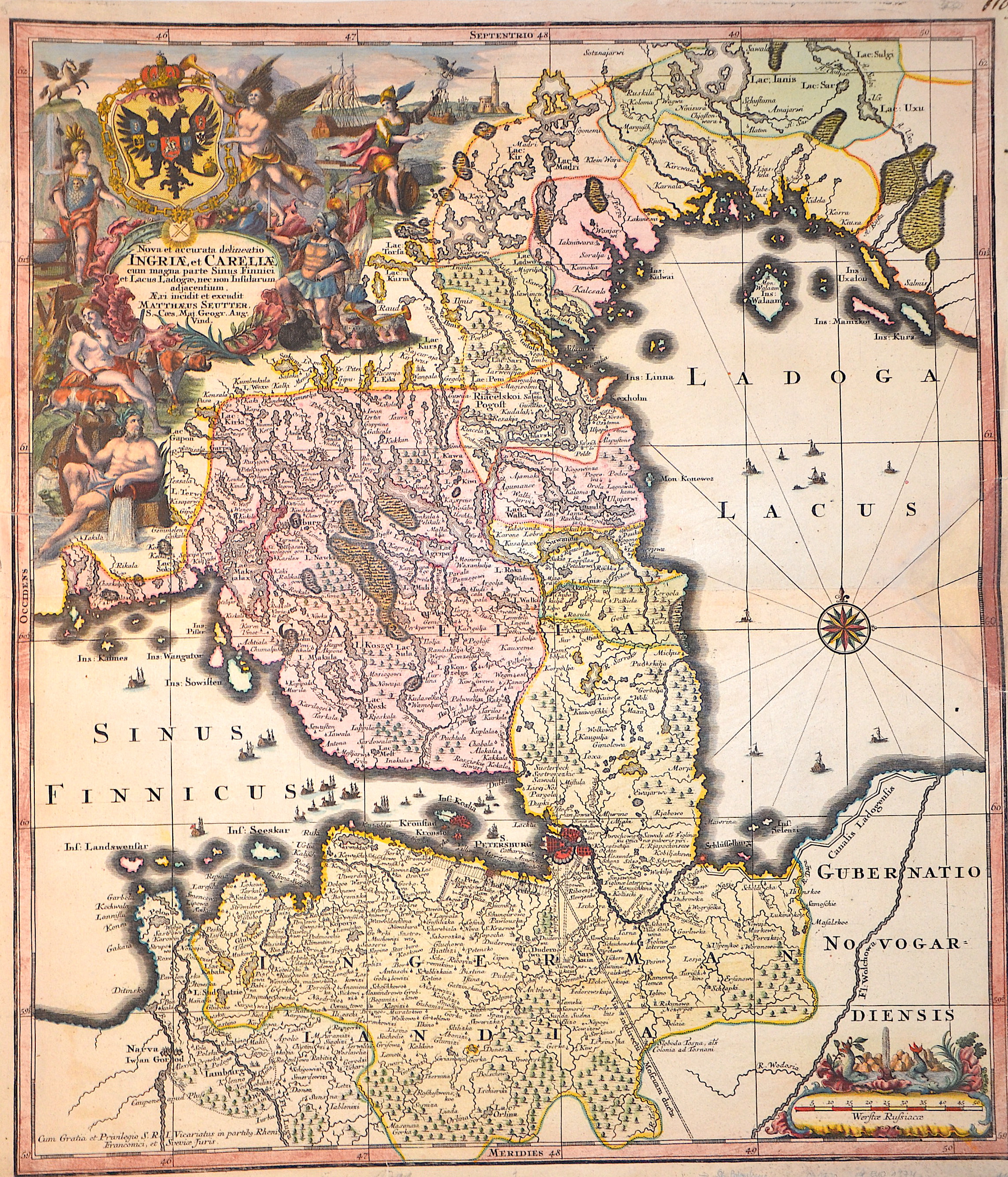
Nova et accurata delineatio Ingriae et Careliae cum magna parte sinus Finnici et lacus Ladogae, nec non insularum adjacentium

| Article ID | EUO1374 |
Title | Nova et accurata delineatio Ingriae et Careliae cum magna parte sinus Finnici et lacus Ladogae, nec non insularum adjacentium |
Description | Map shows southern Finland, Russia with St. Petersburg / Ingermannland and Kronstadt. Furthermore, many ship staffages in the sea, a magnificent title cartouche with coats of arms and gods as well as a compass rose and a mileage indicator cartouche. |
| Year | ca. 1740 |
Artist | Seutter (1678-1757) |
Matthias Seutter (1678- 1757) Augsburg was the son of a goldsmith in Augsburg. In 1697, Seutter began his studies in Nuremberg and subsequently worked in the publishing house of Jeremias Wolff in Augsburg. In 1710, he established his own publishing house and print shop. The Seutter publishing house produced a great number of maps, atlases, and globes. However, very few original maps were printed there, as Augsburg at that time had no university and no connection to the fields of mathematics or the natural sciences. Seutter therefore copied the work of other cartographers, making his own engravings based on their models. Over 500 maps were produced in his studio. Seutter's most well-known works are the 1725 "Geographical Atlas or an Accurate Depiction of the Whole World" ("Atlas Geographicus oder Accurate Vorstellung der ganzen Welt") with 46 maps, the 1734 "Large Atlas" ("Grosser Atlas") with 131 maps, and the 1744 pocket atlas "Small Atlas" ("Atlas minor") with 64 maps. Matthäus Seutter died in 1757. Seutter's son Albrecht Karl, his son-in-law Conrad Tobias Lotter, and his business partner Johann Michael Probst ran the printing business for five more years. | |
Historical Description | In the area of St. Petersburg since the 10th century representatives of various Finno-Ugric peoples lived mostly on agriculture. At the beginning of the 14th century, Sweden and Novgorod quarreled over the area. A Swedish settlement at this place, handed down as Landskrona, was allegedly destroyed in 1301. After that, it was agreed that the region should be considered as a buffer zone between the spheres of influence, where no fortresses could be built. In the following centuries, the area was used at least as a landing place for ships sailing on the Neva River, and possibly as a trading center. The latter certainly applies to the period of renewed Swedish dominance in the region after the construction of the Nyenschanz fortress in 1611 and the Nyen settlement that soon surrounded it. Both were located in the urban area of present-day Saint Petersburg on the northern (or right) bank of the Neva River. There is evidence of major urban development ambitions of the Swedes for Nyen in the 17th century. However, these suffered a severe setback when the settlement and fortress were destroyed by Russian troops in 1656 during the Second Northern War. Reconstruction was soon followed by the final conquest of Nyenschanz on May 1, 1703, during the Great Northern War, by the Russians under Sheremetev, who were advancing down the Neva. Nyen had already been preemptively cleared and partially destroyed by the Swedes themselves by this time. The end of Nyen and Nyenschanz simultaneously marked the beginning of the city history of Saint Petersburg in 1703, the year in which the foundation stone for the Peter and Paul Fortress, named after the Tsar's namesake, was laid on an island opposite Nyenschanz in the Neva Delta. |
| Place of Publication | Augsburg |
| Dimensions (cm) | 56 x 48,5 cm |
| Condition | Center partly mounted, tear upper left side perfectly restored |
| Coloring | original colored |
| Technique | Copper print |