

Adina Sommer
Antique and Contemporary Art
Winzerer Str. 154
80797 München
telephone
+49 89 304714
business hours:
by appointment
Email
![]()


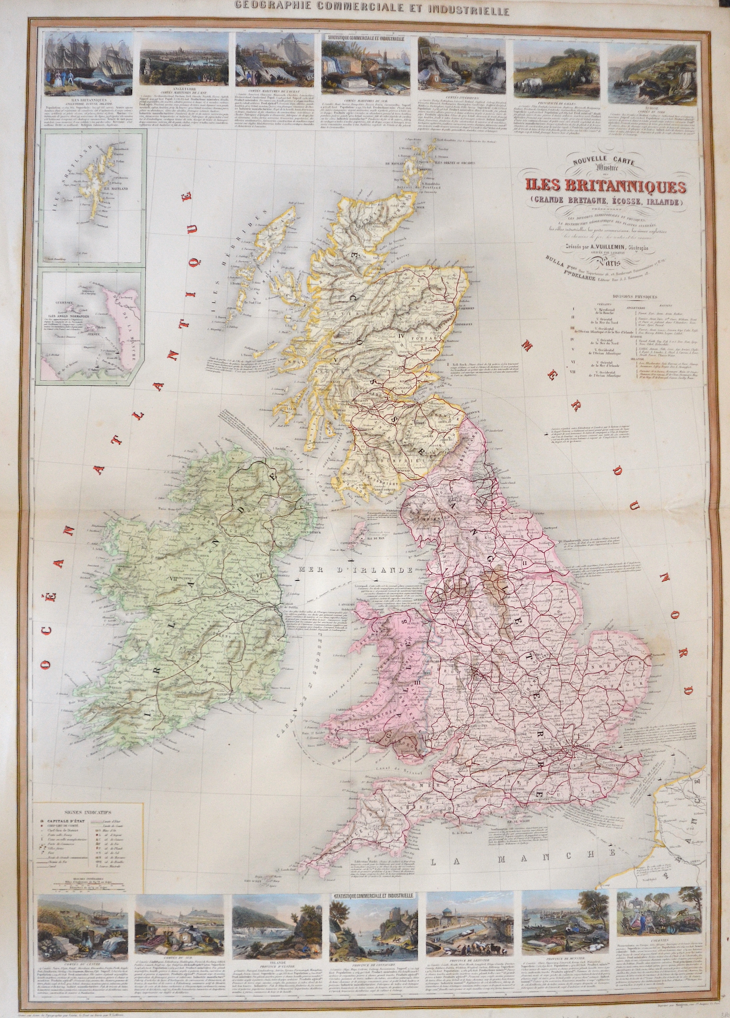
Nouvelle Carte Illustree des Iles Britanniques

| Article ID | EUG3448 |
Title | Nouvelle Carte Illustree des Iles Britanniques |
Description | Map depicts Great Britain or the Channel Islands, on intet maps the Shetland Islands. The map shows all railways in Great Britain with 14 views and its history. |
| Year | ca. 1840 |
Artist | Vuillemin (1812-1880) |
Alexandre Vuillemin (1812-1880) was a prominent 19th century French cartographer and editor based in Paris. He produced a number of atlases, and his maps are noted for the frequent use of extensive margin illustrations – vignettes, famous people, and views of cities. His atlases were popular, and many went through multiple editions. Despite a prolific cartographic career, not a lot is known of Vuillemin's life. He studied under the French cartographer Auguste Dufour (1798 - 1865),and his atlases and maps are held by and available through many collections including the British Museum. | |
Historical Description | The Romans settled for the first time under the leadership of Caesar 55 and 54 BC. BC in England, but initially not as a conqueror. It was not until almost a century later that the Romans occupied England. Scottish ethnic groups repeatedly penetrated the power vacuum that emerged after the Roman withdrawal around 410 AD. Subsequently, groups of Anglers, Jutters and Saxons immigrated. This was the beginning of the early Middle Ages in Britain. The Danish Vikings finally sailed to England in the late 8th century. At first, they only carried out raids, but later they established themselves, asked for tribute payments and built their own villages. Wilhelm's victory in the High Middle Ages led to the introduction of the Normans' effective armrest system. A small Norman upper class almost completely replaced the established nobility. In the period from the middle of the 10th to the middle of the 14th century, the population tripled, and agriculture was intensified with the introduction of three-field farming and land reclamation. However, self-sufficiency with food only succeeded in climatically favorable and politically stable times. The Hundred Years War broke out in the late Middle Ages, the deposition of Richard II by later Henry IV and the failures in the Hundred Years War were the reasons for the outbreak of the subsequent Rose Wars. During the Tudor period, the Renaissance of England peaked through Italian courtiers who reintroduced the artistic, educational, and scientific debate from antiquity. England began to develop naval skills, and exploration of the West and Europe intensified. Henry VIII broke out of communion with the Catholic Church in connection with his divorce under the Acts of Supremacy of 1534, which proclaimed the monarch head of the Church of England. Unlike much of European Protestantism, the roots of the split were political rather than theological. There were internal religious conflicts during the reign of Henry's daughters Mary I and Elizabeth I. The former brought the country back to Catholicism, while the latter abandoned it and vigorously maintained the predominance of Anglicanism. The Elizabethan era began with Elizabeth I's accession to the throne in 1588. The new, Protestant queen was enthusiastically received by the people. From the beginning of her reign, a possible marriage of the queen was the dominant issue. Parliaments repeatedly asked them to obtain a male heir to the throne. She was responsible for the implementation of the Reformation, but also for the poorer relations with Spain. |
| Place of Publication | Paris |
| Dimensions (cm) | 86 x 59,5 cm |
| Condition | Perfect condition |
| Coloring | original colored |
| Technique | Lithography |