

Adina Sommer
Antique and Contemporary Art
Winzerer Str. 154
80797 München
telephone
+49 89 304714
business hours:
by appointment
Email
![]()


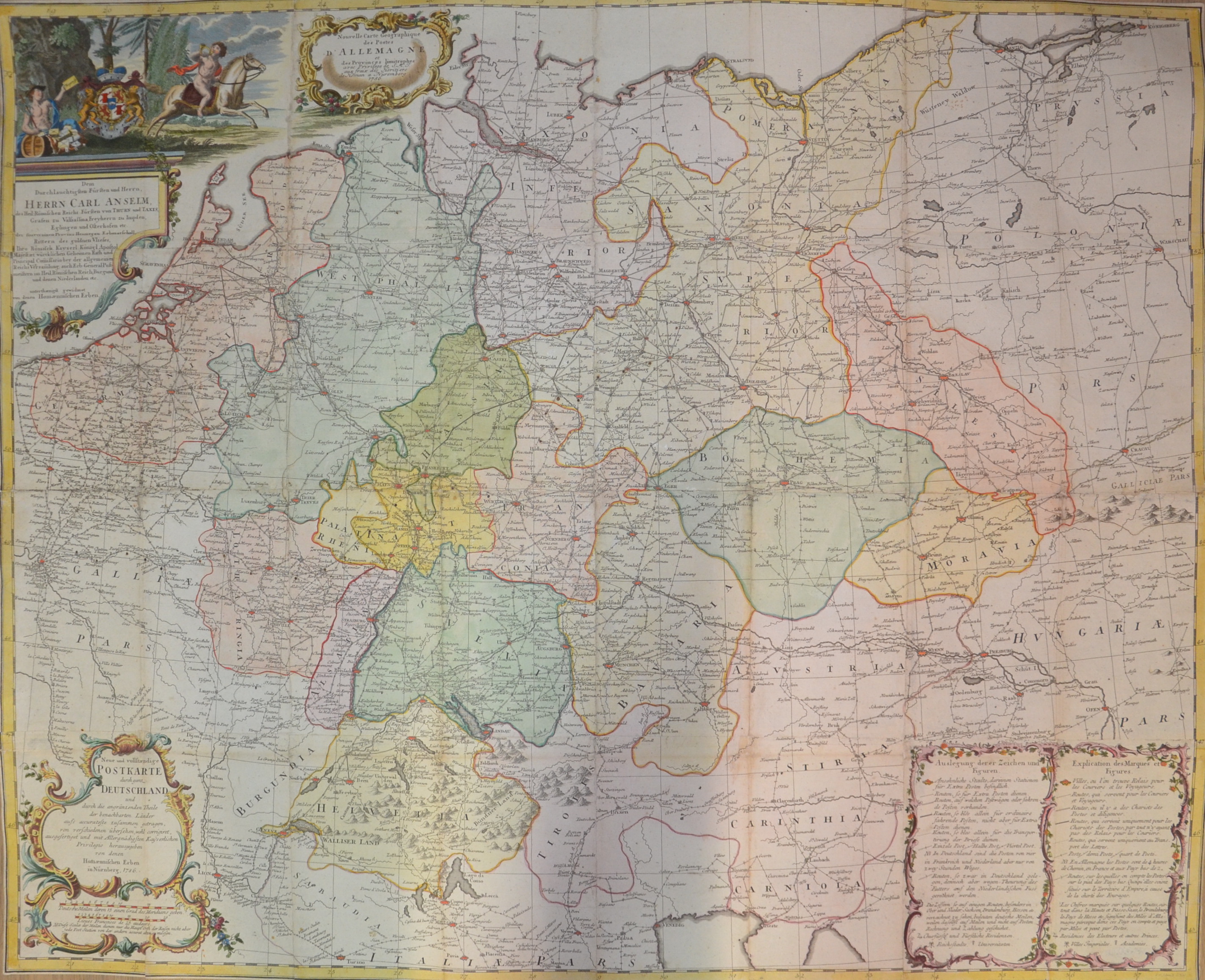
Nouvelle Carte Geographique des Postes d’Allemagne- Dem durchlauch.Fürsten und Herrn Carl Anselm des Heil:Römischen Reichs-Fürsten von Thurn und Taxis

| Article ID | EUD3725 |
Title | Nouvelle Carte Geographique des Postes d’Allemagne- Dem durchlauch.Fürsten und Herrn Carl Anselm des Heil:Römischen Reichs-Fürsten von Thurn und Taxis |
Description | Large map showing the postal routes of all Germany from the time of the Roman Empire Prince of Thurn and Taxis, Counts of Valsassina, Freyherrn Impden, Eglingen and Osterhofen etc.of the Sovereign Province of Hainault Hereditary Marshal Knights of the Golden Fleece. With the Netherlands, Poland, Czech Republic, Austria, Switzerland, Hungary, Romania, northern Italy, partly France with Paris and four magnificent cartouches. Until the late Middle Ages, there was no public postal service in Germany.Maximilian I introduced a new system of messaging in the Holy Roman Empire in 1490 with postal stations, where horsemen exchanged horses and/or messages. Because of the postal contract between Philip the Fair and Francis of Taxis in 1505, the latter has long been credited with founding the first modern postal enterprise. However, this post was initially a dynastic post, not open to the general public. In the second half of the 16th century, other German princes also established their own message boards. At first, these served only the princely post office and not the public. During the Thirty Years' War (1618-1648), the post was of extraordinary importance. The Peace of Westphalia (1648) gave the sovereigns full sovereignty over their territories. No decision was made about the postal sovereignty. In 1658, with the election of Emperor Leopold I. (1640-1705), the rights of the Taxis family, who had called themselves Thurn und Taxis since 1650, to the post of postmaster general in the Holy Roman Empire were confirmed. An additional protocol stipulated that the postal regal of the sovereigns should not be affected by this. Eugen Alexander von Thurn und Taxis was elevated to hereditary princely status as Imperial Postmaster General in the Holy Roman Empire in 1695. Since 1819, the Thurn and Taxis postal territory had comprised: Württemberg, both Hesse and Nassau, the Thuringian states, the Lippe principalities, the Oldenburg principality of Birkenfeld, Hohenzollern and the Free City of Frankfurt am Main. It was not until 1850, with the merger of the German-Austrian Postal Association as an amalgamation of small-state posts, that a uniform rate system came into effect. |
| Year | dated 1786 |
Artist | Homann Erben (1724-1780) |
Johann Babtiste Homann (1664-1724) was born in Oberkammlach, the Electorate of Bavaria. Although educated at a Jesuit school, and preparing for an ecclesiastical career, he eventually converted to Protestantism and from 1687 worked as a civil law notary in Nuremberg. He soon turned to engraving and cartography; in 1702 he founded his own publishing house. Homann acquired renown as a leading German cartographer, and in 1715 was appointed Imperial Geographer by Emperor Charles VI. Giving such privileges to individuals was an added right that the Holy Roman Emperor enjoyed. In the same year he was also named a member of the Prussian Academy of Sciences in Berlin. Of particular significance to cartography were the imperial printing privileges (Latin: privilegia impressoria). These protected for a time the authors in all scientific fields such as printers, copper engravers, map makers and publishers. They were also very important as a recommendation for potential customers. In 1716 Homann published his masterpiece Grosser Atlas ueber die ganze Welt (Grand Atlas of all the World). Numerous maps were drawn up in cooperation with the engraver Christoph Weigel the Elder, who also published Siebmachers Wappenbuch. Homann died in Nuremberg. He was succeeded by the Homann heirs company, which was in business until 1848. The company was known as Homann Erben, Homanniani Heredes, or Heritiers de Homann abroad. | |
Historical Description | The concept of Germany as a distinct region in central Europe can be traced to Roman commander Julius Caesar, who referred to the unconquered area east of the Rhine as Germania, thus distinguishing it from Gaul (France), which he had conquered. In the High Middle Ages, the regional dukes, princes and bishops gained power at the expense of the emperors. Martin Luther led the Protestant Reformationagainst the Catholic Church after 1517, as the northern states became Protestant, while the southern states remained Catholic. The two parts of the Holy Roman Empire clashed in the Thirty Years' War (1618–1648). 1648 marked the effective end of the Holy Roman Empire and the beginning of the modern nation-state system, with Germany divided into numerous independent states, such as Prussia, Bavaria and Saxony. |
| Place of Publication | Nuremberg |
| Dimensions (cm) | 75 x 93 cm |
| Condition | 16 sheets, joined together |
| Coloring | original colored |
| Technique | Copper print |