

Adina Sommer
Antique and Contemporary Art
Winzerer Str. 154
80797 München
telephone
+49 89 304714
business hours:
by appointment
Email
![]()


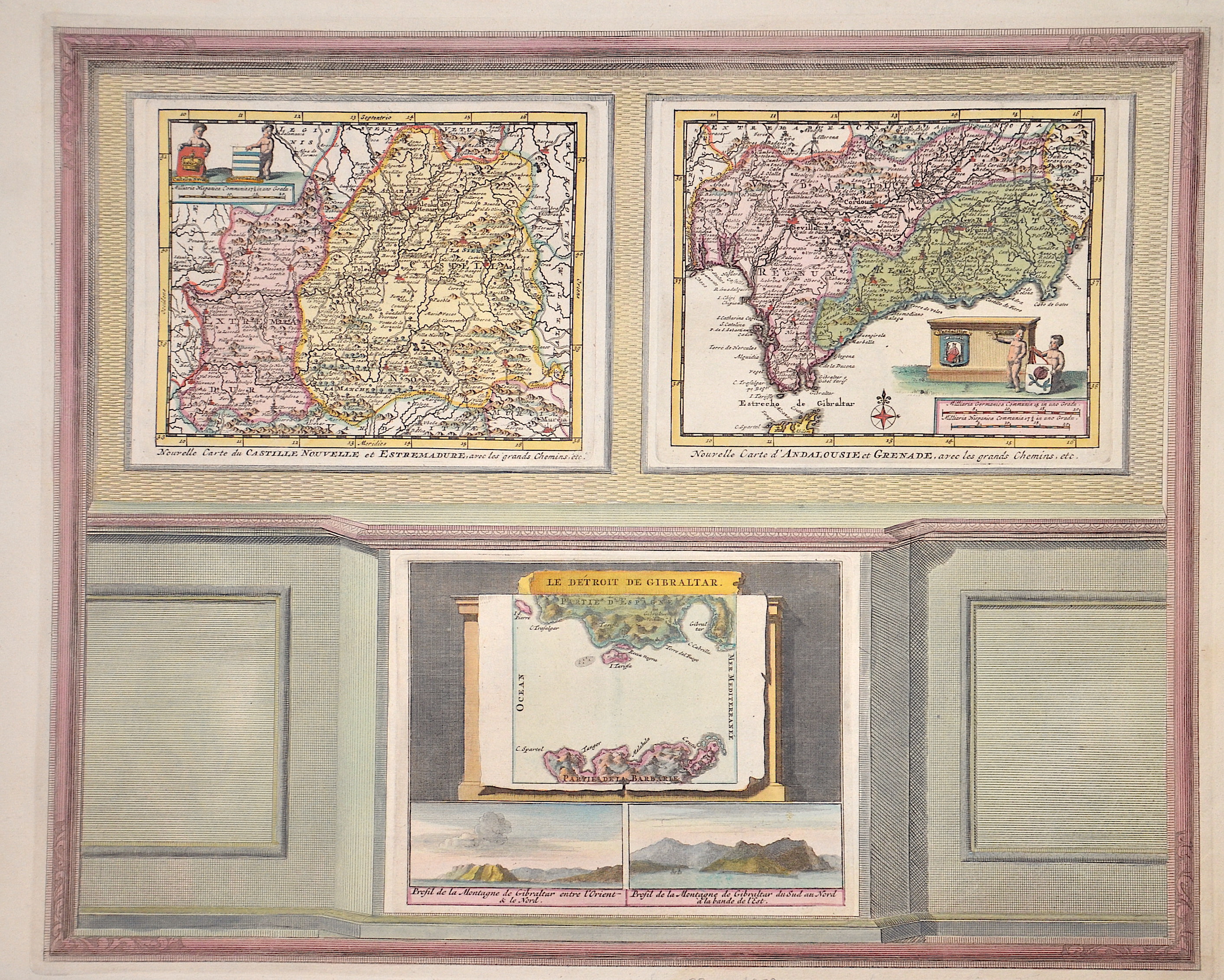
Nouvelle carte du Castille nouvelle et Estremadure/ Nouvelle carte d´Andalusie et Grenade/ Le Dertoit de Gibraltar

| Article ID | EUE1324 |
Title | Nouvelle carte du Castille nouvelle et Estremadure/ Nouvelle carte d´Andalusie et Grenade/ Le Dertoit de Gibraltar |
Description | Map printed on four plates, shows on 3 partial maps New Castile, Andalusia with Granada and Gibraltar. Also two views of Gibraltar. From the "La Galerie Agreable Du Monde". |
| Year | ca. 1729 |
Artist | Aa, van der (1659-1733) |
Pieter van der Aa ( 1659 - 1733) was a Dutch publisher best known for preparing maps and atlases, though he also printed pirated editions of foreign bestsellers and illustrated volumes. He also printed many maps that were often out of print, which he reissued. Some of his most popular maps were of the African continent, detailing locations such as Morocco and Madagascar. Many of his later works were printed for the general public in French and Dutch. Pieter van der Aa began his career at Leiden in 1683 as a Latin trade publisher, publishing classical texts pertaining to medicine and science. As he progressed, he began to publish atlases and maps, compiling numerous multi-volume collections of works. His ambition to become Leiden's most famous printer was fulfilled in 1715 with his appointment to head printer for the city and its university. One of Pieter van der Aa's largest compilations relates to the history of Italy and Sicily, an area of immense personal interest. Though he took credit for many of his compilations, several, such as the Dutch collection of travels to the East and West Indies, were admittedly simple improvements to others' works. | |
Historical Description | From the beginning of the 9th century BC at the latest, the Phoenicians sailed as far as the Andalusian coast, even beyond the Strait of Gibraltar, and traded with the local population. After Phoenician activities were apparently initially limited to trade and the establishment of trading posts in indigenous coastal settlements, they founded their own settlements from the 8th century BC. At the time of Roman rule in Hispania, the Andalusians quickly learned the Latin language and got along quite well with the Roman legionaries. In late antiquity, when the Western Roman Empire was showing signs of dissolution, Vandals and other Germanic tribes invaded Hispania at the beginning of the 5th century. After the middle of the 5th century, the Visigoths conquered Hispania and established their own empire with Toledo as its capital. In the 6th century, parts of Andalusia were occupied by the Eastern Romans, who, however, had to withdraw at the beginning of the 7th century. In 711 the Moors crossed the straits and within a few years conquered most of the Visigoth Empire. Of all the Spanish regions, Andalusia was under Islamic rule the longest. It reached its zenith under the Emirate of Córdoba, the Caliphate of Córdoba, and the Nasrids in the Emirate of Granada. The influences of the Muslims can be seen above all in the architecture, including the Alhambra in Granada, the Mezquita of Córdoba and the Giralda in Seville. The rule of the Moors in Spain was ended by the Reconquista (1492) in Granada. Despite all the guarantees of religious freedom granted in the Treaty of Granada (1491), the forced conversion of the Mudejares by the Catholic Church and the expropriation of Muslim religious institutions soon began (formally in 1502). The city of Seville became the maritime trade center of Spain in the 16th and 17th centuries. During this period, the port of Seville held the monopoly over overseas trade. Amerigo Vespucci and Ferdinand Magellan planned and launched their voyages of discovery here. |
| Place of Publication | Leiden |
| Dimensions (cm) | 33,5 x 41 cm |
| Condition | Perfect condition |
| Coloring | original colored |
| Technique | Copper print |