

Adina Sommer
Antique and Contemporary Art
Winzerer Str. 154
80797 München
telephone
+49 89 304714
business hours:
by appointment
Email
![]()


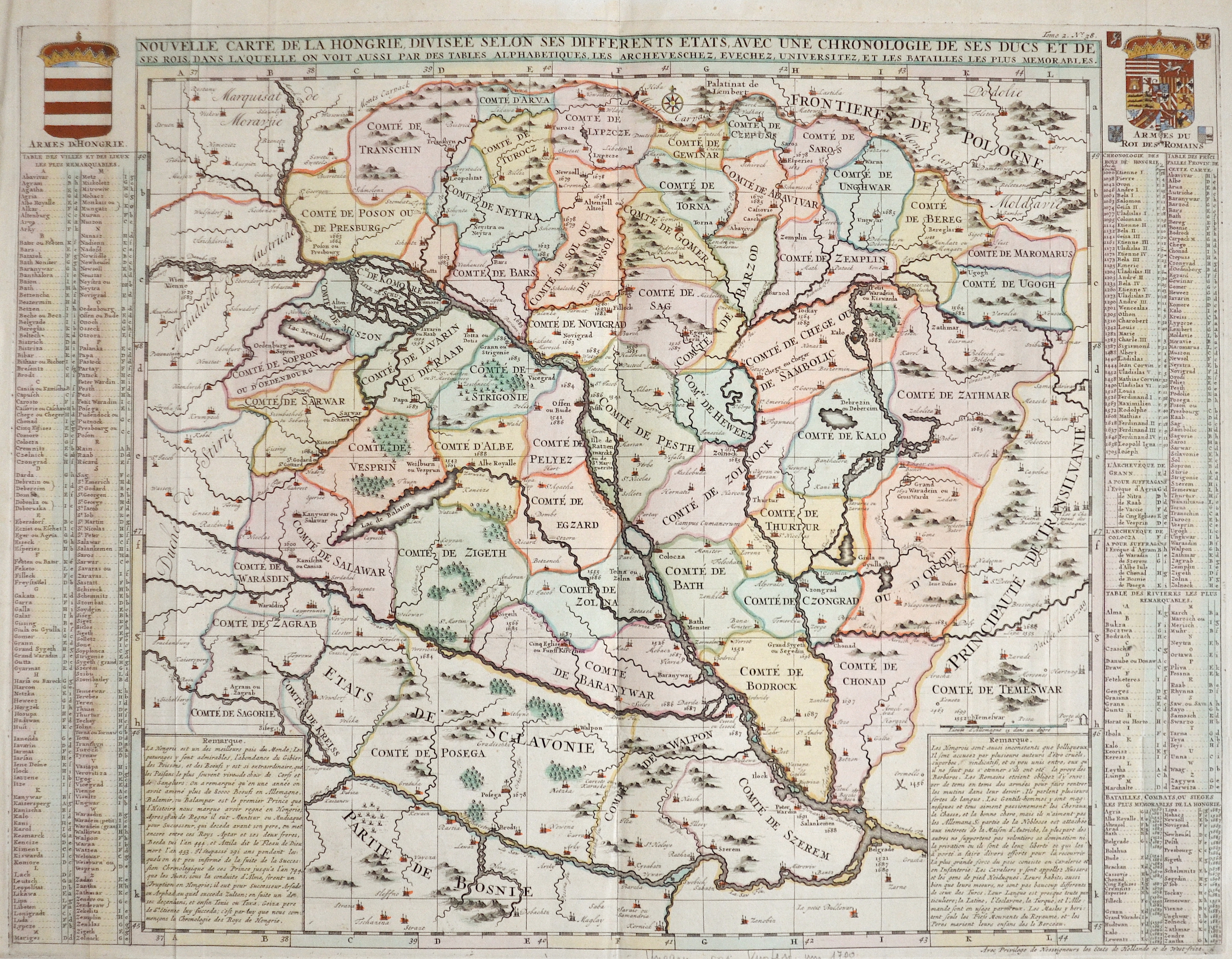
Nouvelle Carte de la Hongrie, divisee selon ses differents etats, avec une Chronologie de ses ducs et de ses..

| Article ID | EUH4244 |
Title | Nouvelle Carte de la Hongrie, divisee selon ses differents etats, avec une Chronologie de ses ducs et de ses.. |
Description | Map shows total Ungarn. Includes coat of arms and explanatory text. |
| Year | ca. 1719 |
Artist | Chatelain (1684-1743) |
Henri Abraham Chatelain (1684 - 1743) was a Huguenot pastor of Parisian origins. He lived consecutively in Paris, St. Martins, London (c. 1710), The Hague (c. 1721) and Amsterdam (c. 1728). He is best known as a Dutch cartographer and more specifically for his cartographic contribution in the seminal seven volume Atlas Historique, published in Amsterdam between 1705 and 1720. Innovative for its time, the Atlas Historique combined fine engraving and artwork with scholarly studies of geography, history, ethnology, heraldry, and cosmography. Some scholarship suggests that the Atlas Historique was not exclusively compiled by Henri Chatelain, as is commonly believed, but rather was a family enterprise involving Henri, his father Zacharie and his brother, also Zacharie. | |
Historical Description | The Kingdom of Hungary existed in changing borders from 1001 to 1918 and 1920 to 1946, originating in what is now western Hungary and subsequently expanding its domain to include the entire territory of present-day Hungary, as well as the territory of Transylvania, the Kreish and Maramures (both in the Romanian part of the Partium), Slovakia, Vojvodina, the Romanian part of the Banat, Carpatho-Ukraine, Burgenland, Prekmurje, Croatia (except Dalmatia and Istria) and some smaller territories. The first king of the kingdom was Stephen I the Saint from the ruling dynasty of the Árpáds, who was formally recognized as king of Hungary in 1001, when Pope Silvester II granted him the title of "Apostolic Majesty". In 1396, the Ottomans had to face a crusader army under the Hungarian king and later emperor Sigismund, which was crushingly defeated at the Battle of Nicopolis. The European powers, first and foremost the Holy Roman Empire, which had not considered the Ottomans as a serious threat for too long, were faced with the ruins of their policies concerning the Ottoman Empire at the latest with the fall of the medieval Kingdom of Hungary (1526). In the following decades, therefore, the only thing that mattered was to prevent, as far as possible, the further advance of the Ottomans towards Central Europe. In 1526 the decision in the fight against the Ottoman Empire followed in the Battle of Mohács. The Hungarian King Louis II fell in the battle. The following Hungarian Civil War, in which John I was supported by the Turks, ended in 1538 with the Peace of Grosswardein. John Zápolya and Ferdinand were both allowed to continue to use the Hungarian royal title and to rule a part of Hungary. To forestall Habsburg claims, Suleyman I intervened and occupied Buda and central Hungary. Hungary was divided into three parts after 1540 according to the power relations created. The exact demarcation of the borders between the individual parts varied considerably. After the Habsburgs and their allies had pushed the Ottoman Empire back to the territories south of the Danube and the Sava and fixed this in the Peace of Karlowitz in 1699, the Kingdom of Hungary, which had never disappeared de jure, was also restored de facto. The k.u.k. Monarchy existed until its defeat in World War I, when Hungary denounced the Real Union as of October 31, 1918. A short time later, the Hungarian Republic was proclaimed. The kingdom was under several foreign dominations in its history and regained its sovereignty in 1867 as a federal (partial) state of Austria-Hungary. |
| Place of Publication | Amsterdam |
| Dimensions (cm) | 48 x 62,5 cm |
| Condition | Perfect condition |
| Coloring | colored |
| Technique | Copper print |