

Adina Sommer
Antique and Contemporary Art
Winzerer Str. 154
80797 München
telephone
+49 89 304714
business hours:
by appointment
Email
![]()


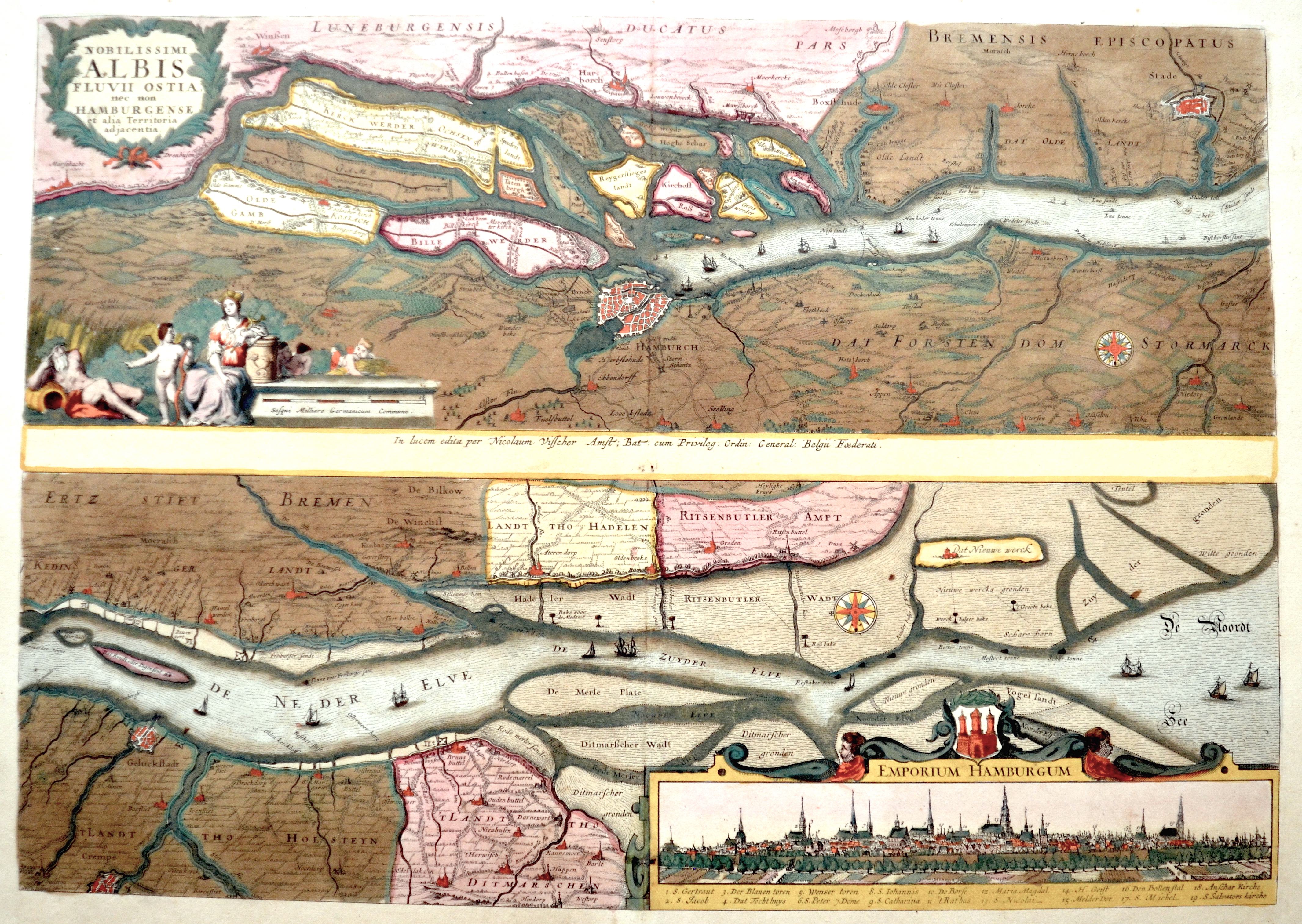
Nobilissimi Albis Fluvii Ostia, nec non Hamburgense et alia Territoria adjacentia.l

| Article ID | EUD3979 |
Title | Nobilissimi Albis Fluvii Ostia, nec non Hamburgense et alia Territoria adjacentia.l |
Description | Two maps on one sheet showing the river Elbe in Germany. With 3 magnificent cartouches and a totla view of Hamburg. With coat of arms, decorative ships representation and a windrose. |
| Year | ca. 1670 |
Artist | Visscher (1618-1679) |
Nicolaes Visscher I (1618 -1679) Amsterdam was a Dutch engraver, cartographer and publisher. He belonged to the Dutch art dealer, engraver and publisher dynasty founded by his father Claes Janszoon Visscher. After his father's death in 1652, he took over his father's art publishing house and initially continued publishing the atlases and maps that his father had begun. He then began publishing works under his own name. Together with his son Nicolaes Visscher II (1649-1702), he engraved a large number of printing plates, further replenishing the publisher's stock. The atlases "Atlas Contractus", "Atlas Minor" and "Germania Inferior" contain about 170 plates. After N. Visscher's death, some of Visscher's copper plates passed to Petrus Schenk II (1693-1775), who used them for numerous reprints. | |
Historical Description | Graf Adolf III. von Schauenburg und Holstein war im 12. Jahrhundert der Gründer einer Handels- und Marktsiedlung am westlichen Alsterufer. It rose on rocky terrain in a marsh between the River Alster and the River Elbe as a defence against Slavic incursion, and acquired the name Hammaburg, burg meaning castle or fort. In 1189, by imperial charter, Frederick I "Barbarossa" granted Hamburg the status of a Free Imperial City and tax-free access (or free-trade zone) up the Lower Elbe into the North Sea. In 1265, an allegedly forged letter was presented to or by the Rath of Hamburg. In 1529, the city embraced Lutheranism, and it received Reformed refugees from the Netherlands and France. When Jan van Valckenborgh introduced a second layer to the fortifications to protect against the Thirty Years War in the seventeenth century, he extended Hamburg and created a "New Town" (Neustadt) whose street names still date from the grid system of roads he introduced. Upon the dissolution of the Holy Roman Empire in 1806, the Free Imperial City of Hamburg was not incorporated into a larger administrative area while retaining special privileges (mediatised), but became a sovereign state with the official title of the Free and Hanseatic City of Hamburg. Hamburg was briefly annexed by Napoleon I to the First French Empire (1804–1814/1815). Russian forces under General Bennigsen finally freed the city in 1814. Hamburg re-assumed its pre-1811 status as a city-state in 1814. The Vienna Congress of 1815 confirmed Hamburg's independence and it became one of 39 sovereign states of the German Confederation (1815–1866). |
| Place of Publication | Amsterdam |
| Dimensions (cm) | 37,5 x 53 |
| Condition | Some restoration at lower centerfold |
| Coloring | original colored |
| Technique | Copper print |