

Adina Sommer
Antique and Contemporary Art
Winzerer Str. 154
80797 München
telephone
+49 89 304714
business hours:
by appointment
Email
![]()


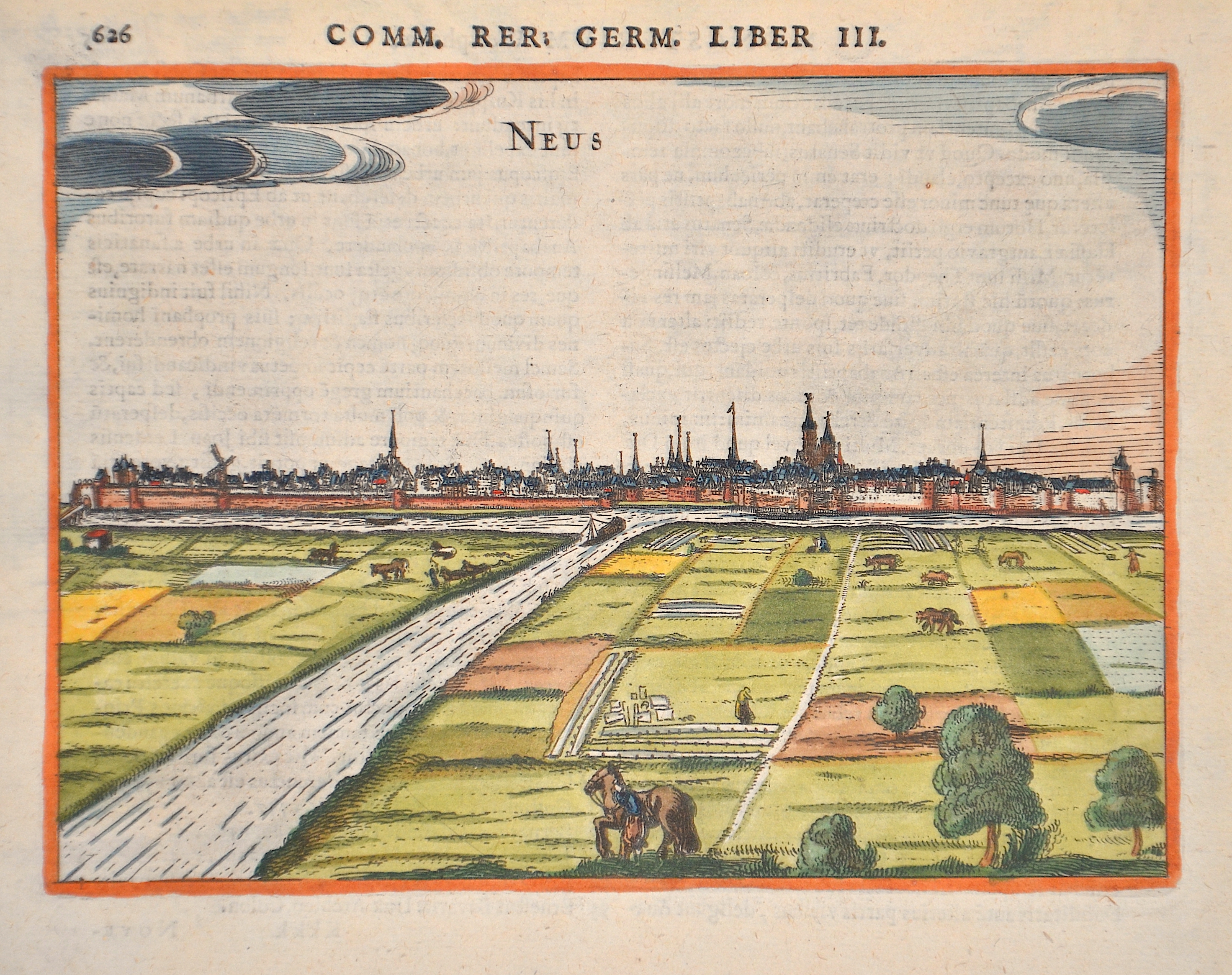
Neus / 626 Comm. Rer. Germ. Liber III.

| Article ID | EUD1898 |
Title | Neus / 626 Comm. Rer. Germ. Liber III. |
Description | Map shows the city of Neuss |
| Year | ca. 1620 |
Artist | Bertius (1565-1629) |
Petrus Bertius (1565 -1629) was a Flemish theologian, historian, geographer and cartographer, He grew up in Beveren (Flanders). In 1593 he was appointed mathematics professor and librarian of the University of Leyden. His main cartographic work includes a miniature world atlas of 1600, a pocket atlas of the German Empire of 1616 with 26 engraved maps and 101 city views, a version of the Geographia of Ptolemy with 28 maps by Mercator and 14 maps from the Parergon of Ortelius of 1618, but he is known today as a cartographer with his edition of the Geographia of Ptolemy (based on Mercator's edition of 1578) and for his atlas. | |
Historical Description | The first written account of the area was by its conqueror, Julius Caesar, the territories west of the Rhine were occupied by the Eburones and east of the Rhine he reported the Ubii (across from Cologne) and the Sugambri to their north. The Ubii and some other Germanic tribes such as the Cugerni were later settled on the west side of the Rhine in the Roman province of Germania Inferior. Julius Caesar conquered the tribes on the left bank, and Augustus established numerous fortified posts on the Rhine, but the Romans never succeeded in gaining a firm footing on the right bank, where the Sugambri neighboured several other tribes including the Tencteri and Usipetes. North of the Sigambri and the Rhine region were the Bructeri. and by the end of the fifth century had conquered all the lands that had formerly been under Roman influence. By the eighth century, the Frankish dominion was firmly established in western Germany and northern Gaul, but at the same time, to the north, Westphalia was being taken over by Saxons pushing south. As the central power of the Holy Roman Emperor weakened, the Rhineland split into numerous small, independent, separate vicissitudes and special chronicles. Prussia first set foot on the Rhine in 1609 by the occupation of the Duchy of Cleves and about a century later Upper Guelders and Moers also became Prussian. At the peace of Basel in 1795, the whole of the left bank of the Rhine was resigned to France, and in 1806, the Rhenish princes all joined the Confederation of the Rhine. After the Congress of Vienna, Prussia was awarded the entire Rhineland, which included the Grand Duchy of Berg, the ecclesiastic electorates of Trier and Cologne, the free cities of Aachen and Cologne, and nearly a hundred small lordships and abbeys. The Prussian Rhine province was formed in 1822 and Prussia had the tact to leave them in undisturbed possession of the liberal institutions to which they had become accustomed under the republican rule of the French. In 1920, the districts of Eupen and Malmedy were transferred to Belgium (see German-speaking Community of Belgium). After the Congress of Vienna, the Kingdom of Prussia received a large amount of territory in the Westphalian region and created the province of Westphalia in 1815. The northernmost portions of the former kingdom, including the town of Osnabrück, had become part of the states of Hanover and Oldenburg. |
| Place of Publication | Amsterdam |
| Dimensions (cm) | 14 x 19 cm |
| Condition | Very good |
| Coloring | original colored |
| Technique | Copper print |
Reproduction:
30.00 €
( A reproduction can be ordered individually on request. )