

Adina Sommer
Antique and Contemporary Art
Winzerer Str. 154
80797 München
telephone
+49 89 304714
business hours:
by appointment
Email
![]()


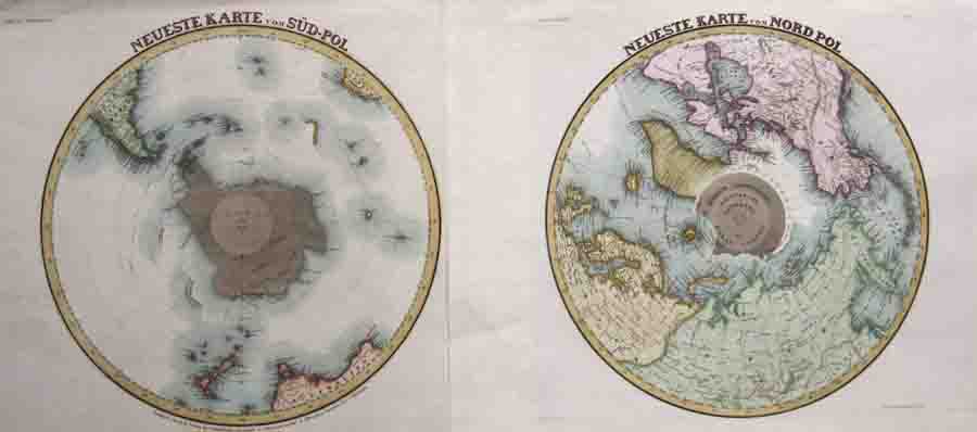
Neueste Karte vom Süd-Pol / Neueste Karte vom Nord Pol

| Article ID | PO0251 |
Title | Neueste Karte vom Süd-Pol / Neueste Karte vom Nord Pol |
Description | Map shows the poles in the the northern and the southern hemispheres in a polar projection, set of 2 maps.( Northpole with Canada, Greenland, partly Europe and Asia/ Southpole with New Zealand, southern Australia, Southamerica). From Meyer's Handatlas |
| Year | ca. 1850 |
Artist | Meyer (1796-1856) |
Carl Joseph Meyer was a German publisher and founder of the Bibliographical Institute. The birth of life had inspired Meyer to own a personal publishing company. On August 1, 1826, the Bibliographical Institute in Gotha became interests. In 1826 he published the library of German classics (150 volumes). Shortly afterwards after a confirmed series of atlases. Meyer was one of the first publishers in Germany to regulate his books using the subscription process. Headquarters of the Bibliographical Institute in Hildburghausen 1828–1874 Meyer soon insists that the company in Gotha was too small for its rambling activities. He planned the actual publishing house to operate with a printing and bookbinding shop and property and after himself according to the following. The merchant Johann Erdmann Scheller from Hildburghausen, who had offered to be a partner, negotiated with the Duke of Saxony-Meiningen and his government. The Bibliographical Institute moved to Hildburghausen in December 1828 and moved into the last so-called Brunnquellsche Palais. Meyer moved the cabinet library and the miniature library of the German classics here. This is where the third edition of the cheapest classic books in the years 1848–1854 is a definite new edition, its political significance under the perception of the bourgeois-religious revolution of 1848/49 cannot be dismissed out of hand. | |
Historical Description | South Pole: Situated on the continent of Antarctica, it is the site of the United States Amundsen–Scott South Pole Station, which was established in 1956 and has been permanently staffed since that year. The Geographic South Pole is distinct from the South Magnetic Pole, the position of which is defined based on Earth's magnetic field. The South Pole is at the center of the Southern Hemisphere. In 1820, several expeditions claimed to have been the first to have sighted Antarctica. The basic geography of the Antarctic coastline was not understood until the mid-to-late 19th century. American naval officer Charles Wilkes claimed correctly that Antarctica was a new continent, basing the claim on his exploration in 1839–40, while James Clark Ross, in his expedition of 1839–43, hoped that he might be able to sail all the way to the South Pole. British explorer Robert Falcon Scott on the Discovery Expedition of 1901–04 was the first to attempt to find a route from the Antarctic coastline to the South Pole. The first men to reach the Geographic South Pole were the Norwegian Roald Amundsen and his party on December 14, 1911. Amundsen named his camp Polheim and the entire plateau surrounding the Pole King Haakon VII Vidde in honour of King Haakon VII of Norway. North Pole: While the South Pole lies on a continental land mass, the North Pole is located in the middle of the Arctic Ocean amid waters that are almost permanently covered with constantly shifting sea ice. Attempts to reach the North Pole began in the late 19th century, with the record for "Farthest North" being surpassed on numerous occasions. The first undisputed expedition to reach the North Pole was that of the airship Norge, which overflew the area in 1926 with 16 men on board, including expedition leader Roald Amundsen. Three prior expeditions – led by Frederick Cook (1908, land), Robert Peary (1909, land) and Richard E. Byrd (1926, aerial) – were once also accepted as having reached the Pole. However, in each case later analysis of expedition data has cast doubt upon the accuracy of their claims. |
| Place of Publication | Hildburghausen |
| Dimensions (cm) | 30,5 x 29 |
| Condition | Perfect condition |
| Coloring | original colored |
| Technique | Steel engraving |