

Adina Sommer
Antique and Contemporary Art
Winzerer Str. 154
80797 München
telephone
+49 89 304714
business hours:
by appointment
Email
![]()


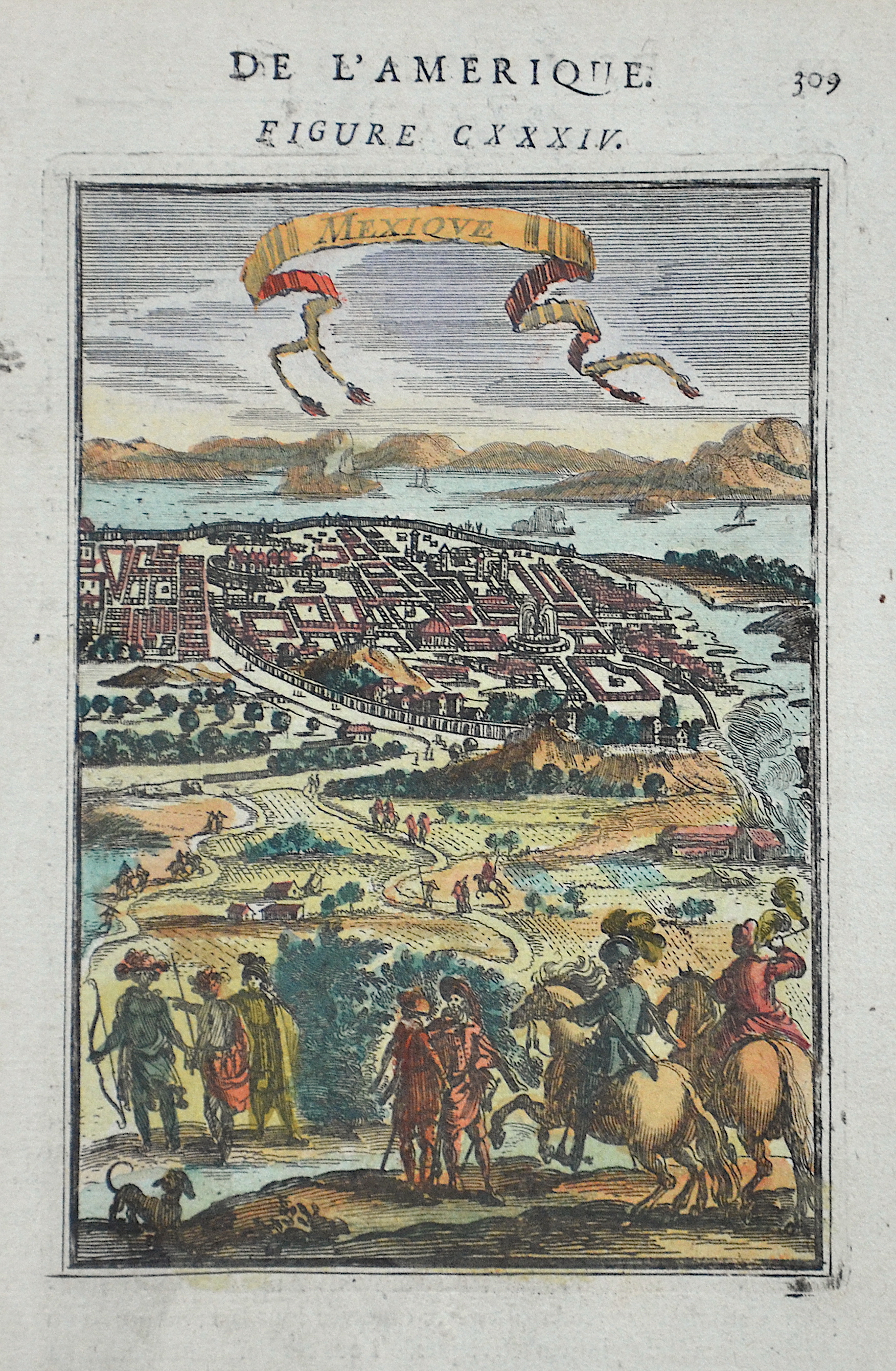
Mexique

| Article ID | AMZ393 |
Title | Mexique |
Description | Birds eye view of Mexico City. |
| Year | ca. 1683 |
Artist | Mallet (1630-1706) |
Alain Manesson Mallet (1630- 1706 ) was a French cartographer and engineer. He started his career as a soldier in the army of Louis XIV, became a Sergeant-Major in the artillery and an Inspector of Fortifications. He also served under the King of Portugal, before returning to France, and his appointment to the court of Louis XIV. His military engineering and mathematical background led to his position teaching mathematics at court. His major publications were Description de L'Univers (1683) in 5 volumes, and Les Travaux de Mars ou l'Art de la Guerre (1684) in 3 volumes. His Description de L'Universe contains a wide variety of information, including star maps, maps of the ancient and modern world, and a synopsis of the customs, religion and government of the many nations included in his text. It has been suggested that his background as a teacher led to his being concerned with entertaining his readers. This concern manifested itself in the charming harbor scenes and rural landscapes that he included beneath his description of astronomical concepts and diagrams. Mallet himself drew most of the figures that were engraved for this book. | |
Historical Description | Mexico City, is the capital of Mexico and the most populous city in North America. It is located in the Valley of Mexico (Valle de México), a large valley in the high plateaus in the center of Mexico. The city of Mexico-Tenochtitlan was founded by the Mexica people in 1325. The old Mexica city that is now simply referred to as Tenochtitlan was built on an island in the center of the inland lake system of the Valley of Mexico, which it shared with a smaller city-state called Tlatelolco. According to legend, the Mexicas' principal god, Huitzilopochtli, indicated the site where they were to build their home by presenting a golden eagle perched on a prickly pear devouring a rattlesnake. When the Spaniards arrived, the Aztec Empire had reached much of Mesoamerica, touching both the Gulf of Mexico and the Pacific Ocean. The city is the political, economic, social and cultural center as well as the country's largest transportation hub. The name México originally goes back to the Aztecs, who called themselves "Mexica. In German-speaking countries, the English-language designation Mexico City is also sometimes used for "Mexico City". For centuries, this basin has been the center of the country, long before there could be any talk of a Mexican nation. The city is surrounded on three sides by mountains - including the famous twin volcanoesPopocatépetl and Iztaccíhuatl and the Sierra Nevada. When the Aztecs arrived in the Valley of Mexico, they found a highly developed hydroponics: Corn, beans, tomatoes, squash and other foods were grown on irrigated land and floating gardens called chinampas. In the 15th century, the Aztecs began to build dikes themselves, which connected the island to the mainland. They also served as aqueducts. According to Aztec records, the founding of the city under the name Tenochtitlan dates back to 1345, when a band of nomads from the north settled on an island in Lake Texcoco. The Aztecs (actually Méxica) settled there after long years of wandering, during which they had subsisted on whatever had been available, voluntarily or involuntarily, in permanent settlements. According to their tradition, they had received the order from their god Huitzilopochtli to found a city at the place where they would find an eagle sitting on a cactus and eating a snake. They found it - on an island in the middle of the lake. Eagle, snake and cactus form the central motif of today's Mexican flag. |
| Place of Publication | Paris |
| Dimensions (cm) | 15 x 9,5 |
| Condition | Very good |
| Coloring | colored |
| Technique | Wood engraving |