

Adina Sommer
Antique and Contemporary Art
Winzerer Str. 154
80797 München
telephone
+49 89 304714
business hours:
by appointment
Email
![]()


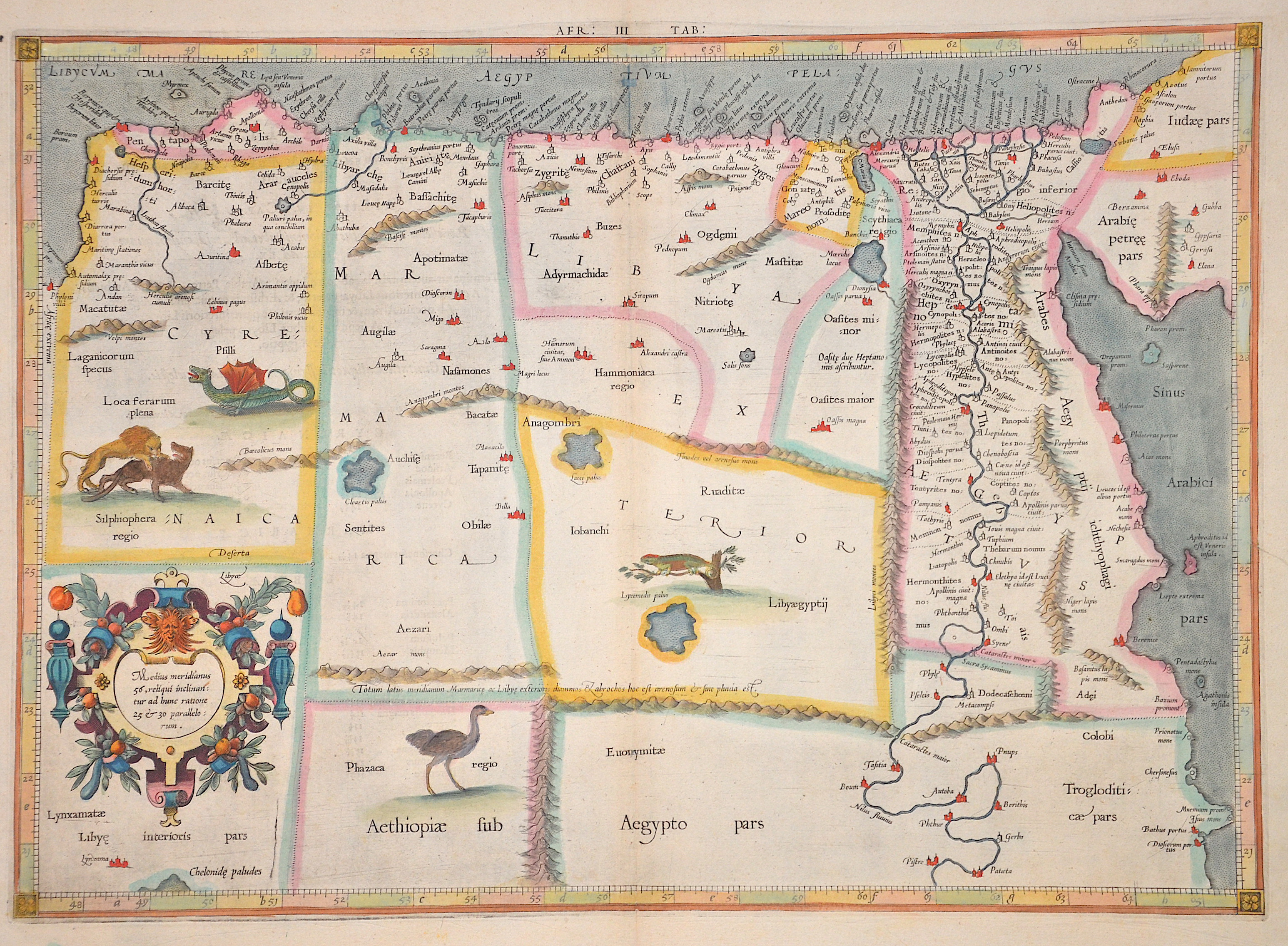
Medius meridianus 56, reliqui inclinantur ad hunc ratione 25 et 30 parallorum

| Article ID | AF0185 |
Title | Medius meridianus 56, reliqui inclinantur ad hunc ratione 25 et 30 parallorum |
Description | Map shows Egypt and Libya with title cartouche and animal staffages in the country. |
| Year | ca. 1578 |
Artist | Ptolemy/ Gerhard Mercator (1512-1594) |
Gerardus Mercator (1512 - 1594) He was a cartographer, philosopher and mathematician. He is best known for his work in cartography, in particular the world map of 1569 based on a new projection which represented sailing courses of constant bearing as straight lines. He is renowned to the present day as the cartographer who created a world map based on a new projection which represented sailing courses of constant bearing as straight lines. In his own day he was the world's most famous geographer but in addition he had interests in theology, philosophy, history, mathematics and magnetism as well as being an accomplished engraver, calligrapher and maker of globes and scientific instruments. He wrote few books but much of his knowledge is to be found in the copious legends on his wall maps and the prefaces that he composed for his atlas ,the first in which the term ""atlas"" appears and the sections within it." Claudius Ptolemy ( arround 100- 160 a.C.) Geographia, gives a list of geographic coordinates of spherical longitude and latitude of almost ten thousand point locations on the earth surface, as they were known at his times. The list is organized in Tabulae which cor- respond to specific regions of the three known continents at that time, Africa, Asia and Europe. Research on Ptolemy’s Geographia has started at the University of Thessaloniki, Greece, in the eighties, focused mainly, but not exclusively, on data re- lated to territories which are now under the sovereignty of the modern Greek state. The World of Ptolemy is classified in Regions, since each Chapter is referred to one of them, giving by this way the concept of Atlas as it is understood today. | |
Historical Description | Already in Egyptian hieroglyphic texts a name for the neighboring tribes to the west appears. The Greeks called the country Libyē, Latin: Libya. In ancient times this meant the land on both sides of the Great Syrte. From the 7th century BC They founded colonies on the coast, including the city of Cyrene. This part of the country, Cyrenaica, came under the rule of Egypt for centuries. In the area adjoining it to the west, the Phoenicians had around 700 BC. The three cities Sabratha, Oea and Leptis Magna founded - the name Tripolitania -Three-Cities-Land- has its origin here. They came as early as the 6th century BC. Under the rule of Carthage. After its destruction in 146 BC Tripolitania came under Roman rule, 96 BC. In BC Cyrenaica also became part of the Roman Empire. During the Roman division of the empire in AD 395, Tripolitania remained with Western Rome, while the Cyrenaica was added to Eastern Rome. In the middle of the 5th century the Vandals invaded Libya; Byzantium succeeded in recapturing from 533 under the leadership of General Belisarius. Between 641 and 644 the Arabs occupied the area; the Berbers resident there were Islamized. At the beginning of the 16th century, Tripolitania was first conquered by the Spaniards, who then ceded the area to the Order of St. John. In 1551 the Ottomans conquered all of Libya. For a long time Tripoli was the base of the corsairs and was repeatedly the target of attacks by European and in 1803 even American navies. |
| Place of Publication | Duisburg |
| Dimensions (cm) | 34,5 x 47,5 cm |
| Condition | Very good |
| Coloring | original colored |
| Technique | Copper print |