

Adina Sommer
Antique and Contemporary Art
Winzerer Str. 154
80797 München
telephone
+49 89 304714
business hours:
by appointment
Email
![]()


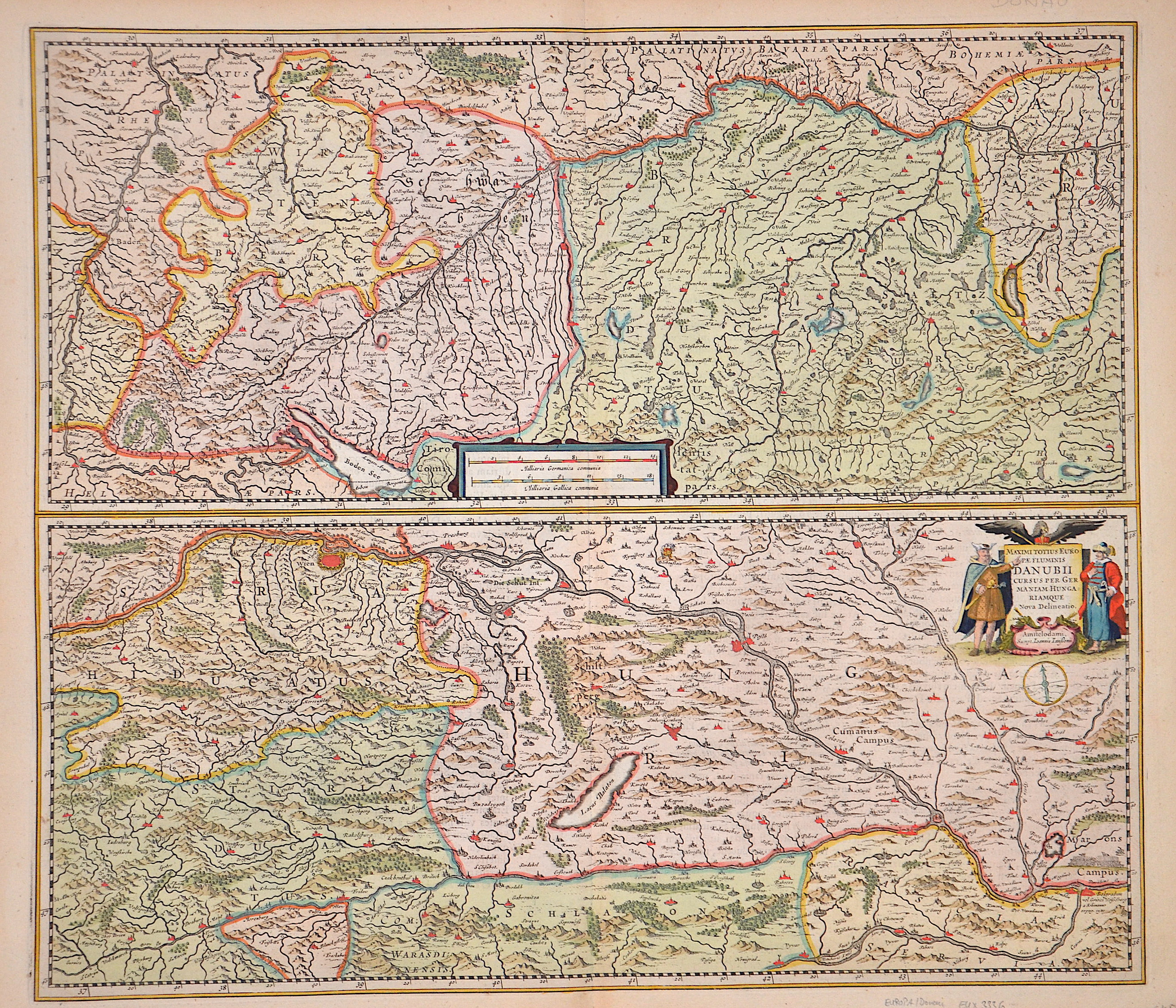
Maximit Totius Europae Fluminis Danubii cursus per Germaniam Hungariamque Nova Delineatio.

| Article ID | EUX3336 |
Title | Maximit Totius Europae Fluminis Danubii cursus per Germaniam Hungariamque Nova Delineatio. |
Description | Map shows the course of the Danube on two maps with the source rivers Brigach and Breg in Germany, continuing through Austria, Slovakia, Hungary, Croatia, Serbia to Belgrade. There is also a compass rose and a title and mileage scale cartouche. |
| Year | ca. 1664 |
Artist | Janssonius/Mercator-Hondius, H. (1588-1664) |
Johannes Janssonius (Jansson),( 1588- 1664) Amsterdam was born in Arnhem, the son of Jan Janszoon the Elder,a publisher and bookseller. In 1612 he married Elisabeth de Hondt, the daughter of Jodocus Hondius. He produced his first maps in 1616 of France and Italy. In 1623 Janssonius owned a bookstore in Frankfurt am Main, later also in Danzig, Stockholm, Copenhagen, Berlin, Königsberg, Geneva and Lyon. In the 1630s he formed a partnership with his brother in law Henricus Hondius, and together they published atlases as Mercator/Hondius/Janssonius. Under the leadership of Janssonius the Hondius Atlas was steadily enlarged. Renamed Atlas Novus, it had three volumes in 1638, one fully dedicated to Italy. 1646 a fourth volume came out with English County Maps, a year after a similar issue by Willem Blaeu. Janssonius' maps are similar to those of Blaeu, and he is often accused of copying from his rival, but many of his maps predate those of Blaeu and/or covered different regions. By 1660, at which point the atlas bore the appropriate name Atlas Major, there were 11 volumes, containing the work of about a hundred credited authors and engravers. It included a description of most of the cities of the world (Townatlas), of the waterworld (Atlas Maritimus in 33 maps), and of the Ancient World (60 maps). The eleventh volume was the Atlas of the Heavens by Andreas Cellarius. Editions were printed in Dutch, Latin, French, and a few times in German. | |
Historical Description | The Danube is the second largest and second longest river in Europe after the Volga. It flows through or touches ten countries (Germany, Austria, Slovakia, Hungary, Croatia, Serbia, Bulgaria, Romania, the Republic of Moldova and Ukraine) - more than any other river in the world. As early as the seventh century BC, Greeks who came from the Black Sea via the city of Tomis, now Constanța, sailed upstream. Their voyage of discovery ended at the Iron Gate, a rocky cataract section with many shallows, whose dangerous course made it impossible for the Greek ships to continue their journey via the Southern Carpathians and the Serbian Ore Mountains. Under the Romans, the Danube formed the border with the peoples to the north almost from its source to its mouth and also served as a transportation route for troops and to supply the settlements downstream. Charlemagne's route, which was used by Gottfried of Bouillon's army during the First Crusade between 1096 and 1099, also ran along the Danube from Regensburg to Belgrade. In 1529, the Turks reached Vienna (then the center of Central Europe) and besieged it, but were defeated. The Ottomans' expansion along the Danube was thus halted and from the second Battle of Mohács (1687) onwards, they lost land and power again. Alongside the Austrians, however, the Ottoman Empire remained the most important political factor in south-eastern Europe until the final loss of its Balkan territories through the Russo-Turkish Wars (1768-1774) and the Balkan Wars of 1912/13. The Danube was not only the main military and commercial artery, but also the political, cultural and religious border between the Orient and the Occident. In the peace treaty of Versailles after the First World War, the Danube was declared an international river in 1919 along with the Elbe, Memel and Oder. This internationalization of the waterway led to hopes arising in the Danube city of Regensburg in 1925 that the city could connect to the rapidly developing international air traffic. Flughafen GmbH Regensburg had a water landing site on the Danube near Winzer. At the time, seaplanes were seen as a promising technology for the short term and the Royal British Government was planning an airmail route with seaplanes across Europe to India with stopovers on the Danube. The plans came to nothing in 1926 / 27 after the rapid development of aviation technology. |
| Place of Publication | Amsterdam |
| Dimensions (cm) | 44,5 x 51 cm |
| Condition | Perfect condition |
| Coloring | original colored |
| Technique | Copper print |