

Adina Sommer
Antique and Contemporary Art
Winzerer Str. 154
80797 München
telephone
+49 89 304714
business hours:
by appointment
Email
![]()


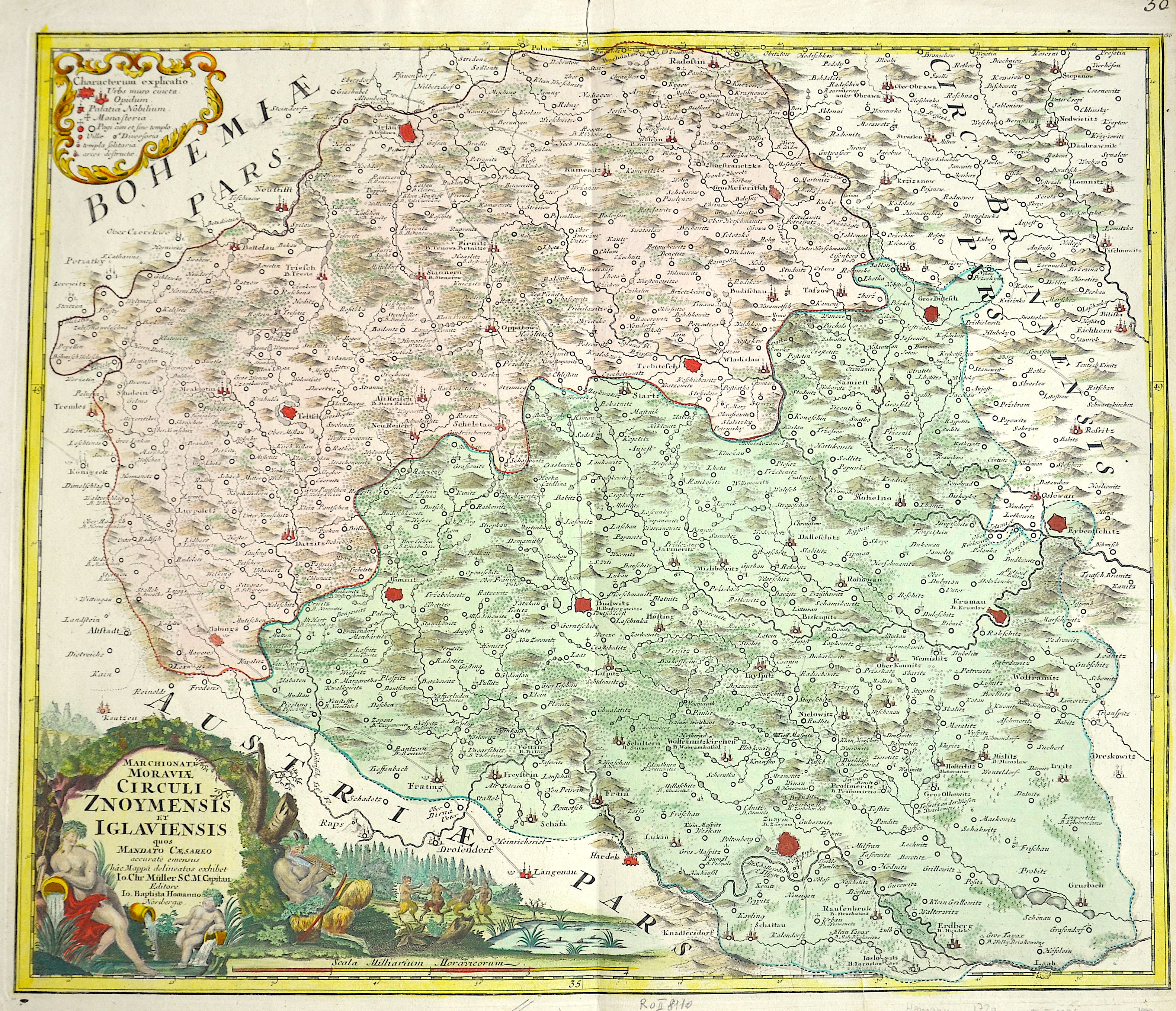
Marchionatus Moraviae circuli Znoymensis et Iglauiensis……

| Article ID | EUT1874 |
Title | Marchionatus Moraviae circuli Znoymensis et Iglauiensis…… |
Description | Map shows Moravia in the Czech Republic with the cities Jihlava, Budweis, Znaim and a magnificent title cartouche. |
| Year | ca. 1710 |
Artist | Homann (1664-1724) |
Johann Babtiste Homann (1664-1724), Nuremberg, was born in Oberkammlach, the Electorate of Bavaria. Although educated at a Jesuit school, and preparing for an ecclesiastical career, he eventually converted to Protestantism and from 1687 worked as a civil law notary in Nuremberg. He soon turned to engraving and cartography; in 1702 he founded his own publishing house. Homann acquired renown as a leading German cartographer, and in 1715 was appointed Imperial Geographer by Emperor Charles VI. Giving such privileges to individuals was an added right that the Holy Roman Emperor enjoyed. In the same year he was also named a member of the Prussian Academy of Sciences in Berlin. Of particular significance to cartography were the imperial printing privileges (Latin: privilegia impressoria). These protected for a time the authors in all scientific fields such as printers, copper engravers, map makers and publishers. They were also very important as a recommendation for potential customers. In 1716 Homann published his masterpiece Grosser Atlas ueber die ganze Welt (Grand Atlas of all the World). Numerous maps were drawn up in cooperation with the engraver Christoph Weigel the Elder, who also published Siebmachers Wappenbuch. Homann died in Nuremberg. He was succeeded by the Homann heirs company, which was in business until 1848. The company was known as Homann Erben, Homanniani Heredes, or Heritiers de Homann abroad. | |
Historical Description | Moravia developed on both sides of the Amber Road in prehistoric times. Around 60 BC The Celtic Boier withdrew from the area and were replaced by Germanic Marcomanni and Quadi, who moved on to the Alpine foothills around 550 AD together with the Rugians. Today's Moravia was still independent for a short time after the devastating defeat against the Hungarians and came under Bohemian sovereignty around 955. After being ruled briefly by Poland's ruler Boleslaw Chrobry from 999 to 1019, Moravia finally became Bohemian in 1031. The Principality and later Kingdom of Bohemia was ruled by the Přemyslid dynasty until it died out in the male line in 1305. Moravian history has been parallel to the history of Bohemia almost continuously since 1031. After the Přemyslids died out, the kingdom was ruled by the House of Luxembourg until 1437. The Přemyslid and Luxembourg dynasties also included the Moravian margraves, so u. a. the later King Ottokar II. Přemysl, the later King and Emperor Charles IV. and his nephew, the largely independent Margrave Jobst of Moravia. In 1469, the Hungarian King Matthias Corvinus advanced with his armed forces to Moravia to overthrow his father-in-law Georg von Podiebrad, whose daughter Katharina he married in 1461, as King of Bohemia. Matthias could never conquer the actual Bohemia, his rule only extended over the Bohemian neighboring countries Moravia, Silesia (with Breslau), Upper and Lower Lusatia. Nevertheless, he called himself King of Bohemia from 1469 and was crowned in 1471. As early as 1526, one of the first communities of property of the radical Reformation Anabaptist movement was formed around Balthasar Hubmaier in the Nikolsburg area. The impending dissolution of the Anabaptist community after the execution of Hubmaier in 1528 was prevented by Jakob Hutter, who came from Tyrol. The Anabaptists were also called the Hutterite Brothers after him. During the Catholic Reform and Recatholization, which were carried out by the Jesuits in particular, many churches were able to be consecrated Catholic again. The capital of Moravia and the seat of the margraves was the centrally located Olomouc from the rule of the Luxembourgers until 1641. After that, the larger Brno became the capital of the country. As the margraviate of Moravia, it formed its own crown land in the Austrian Empire and, from 1867, in the western half of Austria-Hungary. After Hungary left the empire and the real union Austria-Hungary was created in 1867, the remaining crown lands were officially referred to as Cisleithania or the kingdoms and countries represented in the Imperial Council. |
| Place of Publication | Nuremberg |
| Dimensions (cm) | 49 x 57,5 cm |
| Condition | Perfect condition |
| Coloring | colored |
| Technique | Copper print |