

Adina Sommer
Antique and Contemporary Art
Winzerer Str. 154
80797 München
telephone
+49 89 304714
business hours:
by appointment
Email
![]()


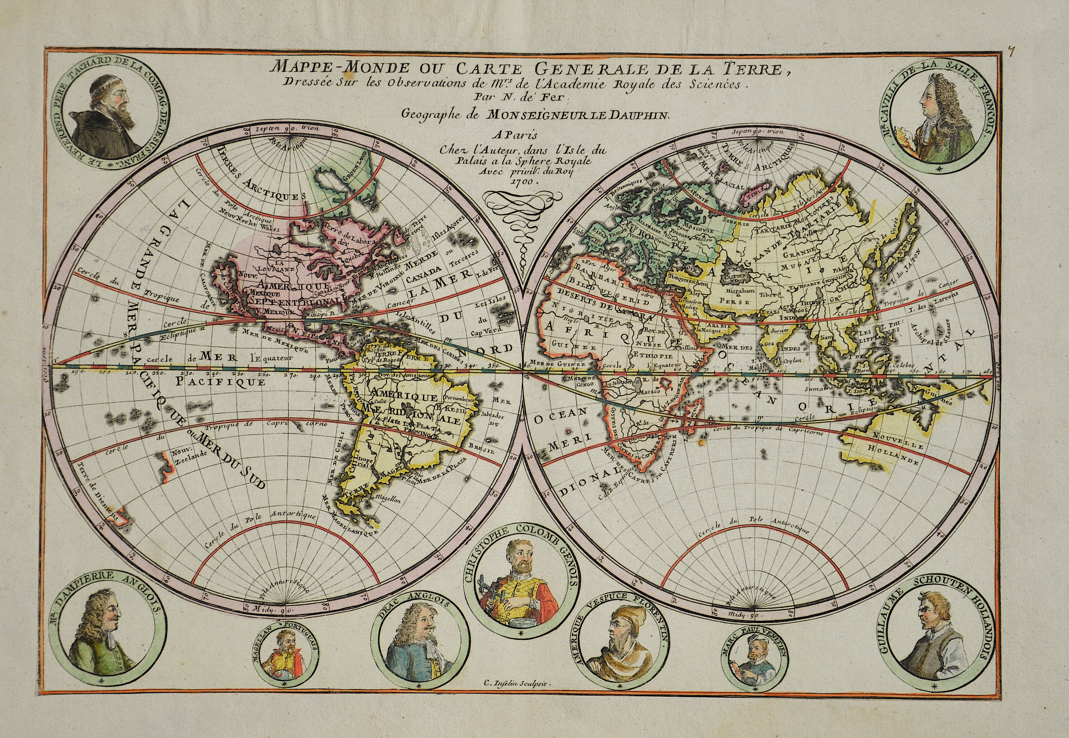
Mappe-Monde ou Carte Generale de la Terre, Dressée sur les observations de Mrs. De l’Academie Royale des Sciences.

| Article ID | W0325 |
Title | Mappe-Monde ou Carte Generale de la Terre, Dressée sur les observations de Mrs. De l’Academie Royale des Sciences. |
Description | Map shows the entire world in two hemispheres with nine portrais (such as Christopher Columbus, Ferdinand Magellan, etc.) |
| Year | c. 1700 |
Artist | Fer, de (1646-1720) |
Nicolas de Fer ( 1646 - 1720 in Paris) was a French cartographer and geographer. He also was an engraver and publisher. De Fer was the youngest of three sons of Antoine de Fer, who was also a cartographer. When he was 12, he became the apprentice of Parisian engraver Louis Spirinx, and made his first map, of the Canal du Midi, at the age of 23. After the death of his father in June 1673, de Fer was so successful at improving the firm that, in 1690, he became the official geographer to Louis, Dauphin of France. With support from the Spanish and French Royal Families, de Fer also became official geographer for Philip V and Louis XIV, the kings of Spain and France, respectively. Because of this, his maps became Bourbon propaganda, endorsing French King Louis XIV. His business flourished, producing town plans, atlases, wall maps, and more than 600 sheet maps.He made maps of places in Europe and North America, including New Spain, places fortified by Vauban, the Low Countries, and the War of the Spanish Succession. In 1698, de Fer published a map of North America, which included a depiction of beavers building dams near Niagara Falls. Seventeen years later, Herman Moll published an identical map as his own, known as the -Beaver map-. De Fer became the official geographer for His Catholic Majesty in 1720.Two of his sons-in-law, Guillaume Danet and Jaques-François Bénard, continued the company after de Fer's death on 25 October of that year until around 1760. | |
Historical Description | Popular science refers to the period from about the 15th to the 18th centuries. The era is considered to be in the early modern period and is primarily concerned with the knowledge of seafarers and explorers. The idea of the age of discoveries is shaped by seafaring and discoveries overseas. In terms of content, however, it also includes astronomy, which is associated with the names of Tycho Brahe, Nikolaus Kopernikus, Isaac Newton and Johannes Kepler, among others. Giordano Bruno and Galileo Galilei also belong to this group. Not only the seafarers with their discoveries, but also they brought about changes in the world view. Some motifs were religious, e.g. B. that Christianity should be spread in the New World (missionary). The great European powers also expected an expansion of their political sphere of influence. This is evident in the overseas colonies, including the Spaniards, Portuguese, English, Dutch and French. The Tordesillas Treaty of 1494 is an example of this. It regulated the distribution of the discovered countries between Portugal and Spain. Global exploration began with the Portuguese discoveries of the Atlantic archipelagos of Madeira and the Azores in 1419 and 1427, the African coast after 1434, and the sea route to India in 1498; and from the Crown of Castile (Spain) the transatlantic trips of Christopher Columbus to America between 1492 and 1502 and the first world tour in the years 1519–1522. These discoveries led to numerous naval expeditions across the Atlantic, Indian and Pacific Oceans, and land expeditions in America, Asia, Africa, and Australia that continued into the late 19th century, followed by exploration of the polar regions in the 20th century. European overseas exploration led to the rise of world trade and the European colonial empires, with contact between the Old World (Europe, Asia and Africa) and the New World (America and Australia) creating Colombian exchange, a wide range of plant transfers, animals, and food , human populations (including slaves), communicable diseases and culture between the Eastern and Western Hemisphere. The age of discovery and later exploration of Europe made it possible to map the world, which led to a new worldview and distant civilizations, but also to the spread of diseases that decimated populations that were not previously in contact with Eurasia and Africa, and to enslavement , Exploitation, military conquest and economic dominance of Europe and its colonies over indigenous people. It also allowed the expansion of Christianity. |
| Place of Publication | Paris |
| Dimensions (cm) | 23 x 34 cm |
| Condition | Mounted |
| Coloring | colored |
| Technique | Copper print |