

Adina Sommer
Antique and Contemporary Art
Winzerer Str. 154
80797 München
telephone
+49 89 304714
business hours:
by appointment
Email
![]()


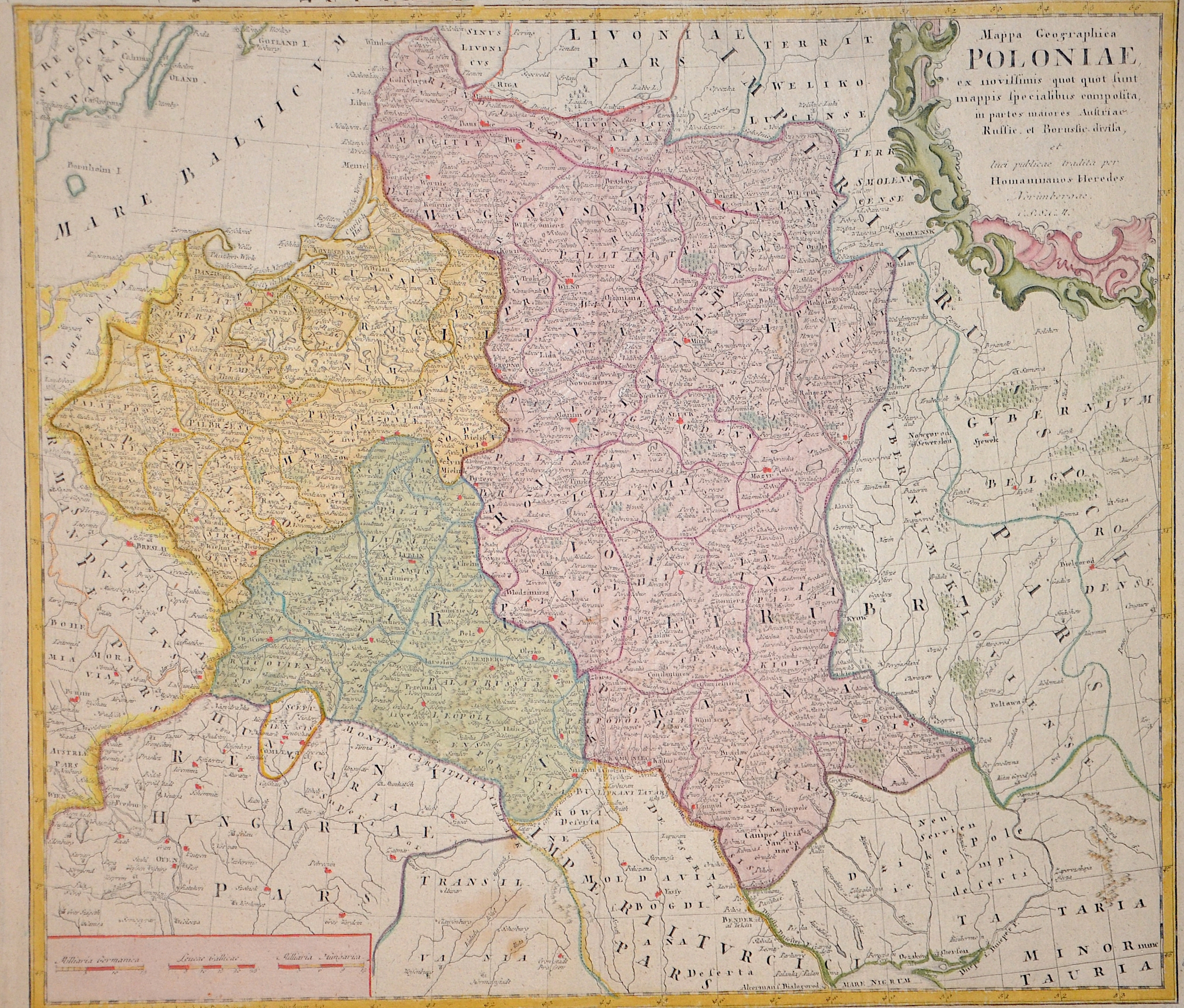
Mappa Geographica Poloniae ex novissimis quot quot sunt. Mappis specialibus composita in parte maiores..

| Article ID | EUP2998 |
Title | Mappa Geographica Poloniae ex novissimis quot quot sunt. Mappis specialibus composita in parte maiores.. |
Description | Map shows the whole of Poland with Lithuania and the Ukraine. Furthermore, a title cartouche and a mileage scale. |
| Year | ca. 1773 |
Artist | Homann Erben (1724-1780) |
Johann Babtiste Homann (1664-1724) was born in Oberkammlach, the Electorate of Bavaria. Although educated at a Jesuit school, and preparing for an ecclesiastical career, he eventually converted to Protestantism and from 1687 worked as a civil law notary in Nuremberg. He soon turned to engraving and cartography; in 1702 he founded his own publishing house. Homann acquired renown as a leading German cartographer, and in 1715 was appointed Imperial Geographer by Emperor Charles VI. Giving such privileges to individuals was an added right that the Holy Roman Emperor enjoyed. In the same year he was also named a member of the Prussian Academy of Sciences in Berlin. Of particular significance to cartography were the imperial printing privileges (Latin: privilegia impressoria). These protected for a time the authors in all scientific fields such as printers, copper engravers, map makers and publishers. They were also very important as a recommendation for potential customers. In 1716 Homann published his masterpiece Grosser Atlas ueber die ganze Welt (Grand Atlas of all the World). Numerous maps were drawn up in cooperation with the engraver Christoph Weigel the Elder, who also published Siebmachers Wappenbuch. Homann died in Nuremberg. He was succeeded by the Homann heirs company, which was in business until 1848. The company was known as Homann Erben, Homanniani Heredes, or Heritiers de Homann abroad. | |
Historical Description | Poland is bordered by the Baltic Sea, Russia's Kaliningrad Oblast and Lithuania to the north, Belarus and Ukraine to the east, Slovakia and Czech Republic, to the south, and Germany to the west. The establishment of the Polish state can be traced back to AD 966, when Mieszko I ruler of the realm coextensive with the territory of present-day Poland, converted to Christianity. The Kingdom of Poland was founded in 1025, and in 1569 it cemented its longstanding political association with the Grand Duchy of Lithuania. This union formed the Polish–Lithuanian Commonwealth, one of the largest at the end of the 18th century. Poland regained its independence in 1918 with the Treaty of Versailles. It was one of the most populous countries of 16th- and 17th-century Europe, with a uniquely liberal political system, which adopted Europe's first written national constitution, the Constitution of 1791. |
| Place of Publication | Nuremberg |
| Dimensions (cm) | 45,5 x 50 cm |
| Condition | Perfect condition |
| Coloring | original colored |
| Technique | Copper print |