

Adina Sommer
Antique and Contemporary Art
Winzerer Str. 154
80797 München
telephone
+49 89 304714
business hours:
by appointment
Email
![]()


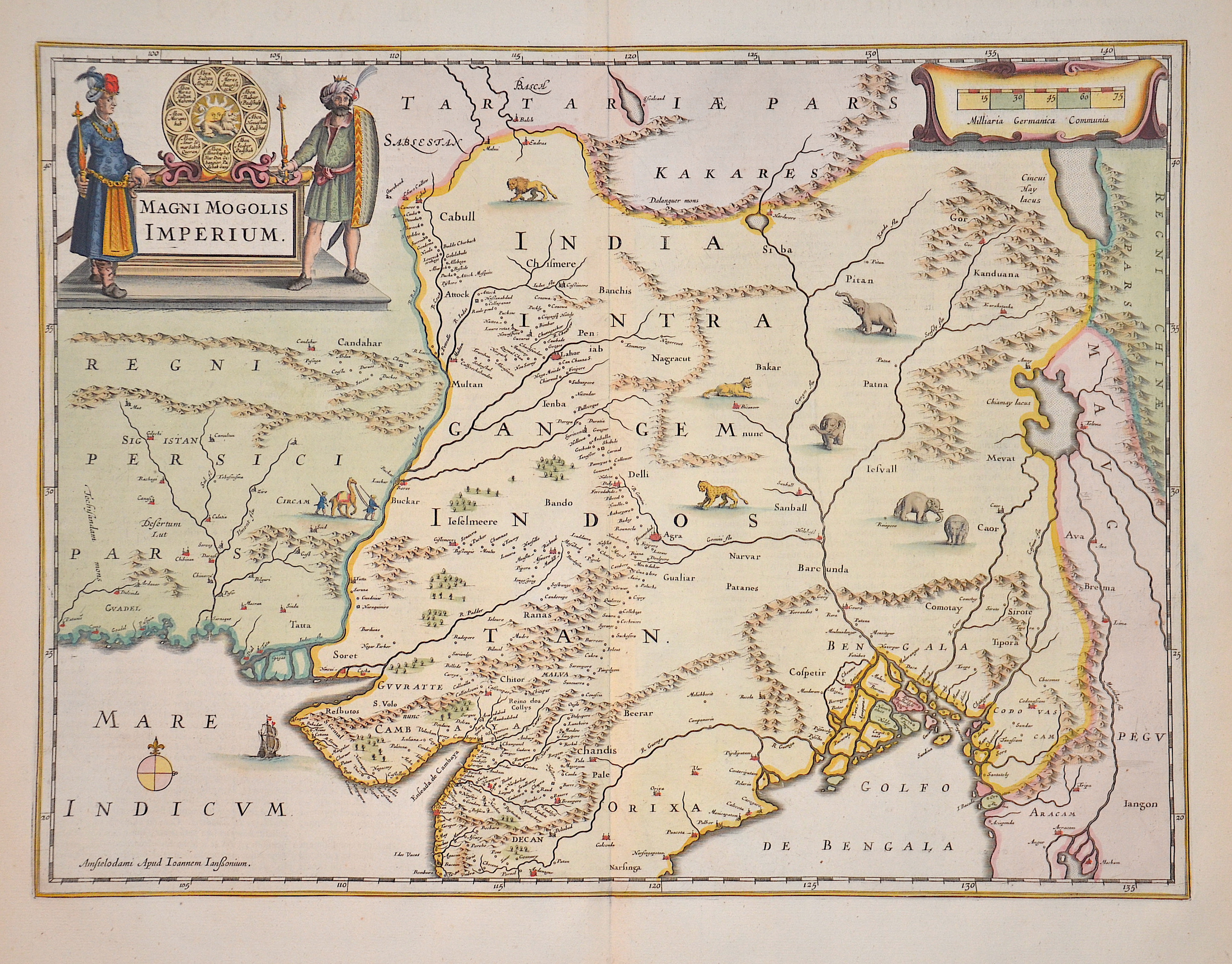
Magni Mogolis Imperium

| Article ID | ASI218 |
Title | Magni Mogolis Imperium |
Description | The map shows mostly India and the region bounded by Pakistan, Afganistan and Bangladesh. It extends inland up the Ganges and Indus Rivers to Tartary and the Himalayas. It shows Katmandu, Kabul and other cities along the great trading routes. |
| Year | ca. 1666 |
Artist | Janssonius (1588-1664) |
Johannes Janssonius (Jansson)( 1588- 1664) Amsterdam, was born in Arnhem, the son of Jan Janszoon the Elder, a publisher and bookseller. In 1612 he married Elisabeth de Hondt, the daughter of Jodocus Hondius. He produced his first maps in 1616 of France and Italy. In 1623 Janssonius owned a bookstore in Frankfurt am Main, later also in Danzig, Stockholm, Copenhagen, Berlin, Königsberg, Geneva and Lyon. In the 1630s he formed a partnership with his brother in law Henricus Hondius, and together they published atlases as Mercator/Hondius/Janssonius. Under the leadership of Janssonius the Hondius Atlas was steadily enlarged. Renamed Atlas Novus, it had three volumes in 1638, one fully dedicated to Italy. 1646 a fourth volume came out with ""English County Maps"", a year after a similar issue by Willem Blaeu. Janssonius' maps are similar to those of Blaeu, and he is often accused of copying from his rival, but many of his maps predate those of Blaeu and/or covered different regions. By 1660, at which point the atlas bore the appropriate name ""Atlas Major"", there were 11 volumes, containing the work of about a hundred credited authors and engravers. It included a description of ""most of the cities of the world"" (Townatlas), of the waterworld (Atlas Maritimus in 33 maps), and of the Ancient World (60 maps). The eleventh volume was the Atlas of the Heavens by Andreas Cellarius. Editions were printed in Dutch, Latin, French, and a few times in German. | |
Historical Description | After the 10th century, Muslim Central Asian nomadic clans, using swift-horse cavalry and raising vast armies united by ethnicity and religion, repeatedly overran South Asia's north-western plains, leading eventually to the establishment of the Islamic Delhi Sultanate in 1206. The sultanate was to control much of North India and to make many forays into South India. Although at first disruptive for the Indian elites, the sultanate largely left its vast non-Muslim subject population to its own laws and customs. By repeatedly repulsing Mongol raiders in the 13th century, the sultanate saved India from the devastation visited on West and Central Asia, setting the scene for centuries of migration of fleeing soldiers, learned men, mystics, traders, artists, and artisans from that region into the subcontinent, thereby creating a syncretic Indo-Islamic culture in the north. The sultanate's raiding and weakening of the regional kingdoms of South India paved the way for the indigenous Vijayanagara Empire. Embracing a strong Shaivite tradition and building upon the military technology of the sultanate, the empire came to control much of peninsular India and was to influence South Indian society for long afterwards. n the early 16th century, northern India, then under mainly Muslim rulers fell again to the superior mobility and firepower of a new generation of Central Asian warriors. The resulting Mughal Empire did not stamp out the local societies it came to rule. Instead, it balanced and pacified them through new administrative practices and diverse and inclusive ruling elites, leading to more systematic, centralised, and uniform rule. Eschewing tribal bonds and Islamic identity, especially under Akbar, the Mughals united their far-flung realms through loyalty, expressed through a Persianised culture, to an emperor who had near-divine status. The Mughal state's economic policies, deriving most revenues from agriculture and mandating that taxes be paid in the well-regulated silver currency caused peasants and artisans to enter larger markets. Newly coherent social groups in northern and western India, such as the Marathas, the Rajputs, and the Sikhs, gained military and governing ambitions during Mughal rule, which, through collaboration or adversity, gave them both recognition and military experience. By the early 18th century, with the lines between commercial and political dominance being increasingly blurred, a number of European trading companies, including the English East India Company, had established coastal outposts. The East India Company's control of the seas, greater resources, and more advanced military training and technology led it to increasingly flex its military muscle and caused it to become attractive to a portion of the Indian elite; these factors were crucial in allowing the company to gain control over the Bengal region by 1765 and sideline the other European companies. |
| Place of Publication | Amsterdam |
| Dimensions (cm) | 37 x 49 |
| Condition | Very good |
| Coloring | colored |
| Technique | Copper print |