

- Alsace
- Aquitaine
- Auvergne
- Bourgogne
- Bourgogne-Franche-Comte
- Brittany
- Centre
- Champagne
- France Islands
- Gascogne
- Gironde
- Hauts-de-France
- Ile de France
- Languedoc
- Lothringen
- Midi-Pyrénées
- Nivernais
- Nord-Pas-de-Calais
- Normandie
- Occitanie
- Pas-de-Calais
- Pays de la Loire
- Picardie
- Poitou-Charentes
- Provence-Alpes-Cote d Azur
- Pyrénées
- Rhone- Alpes
- Saintonge
- Savoyen
- Tourain
- Westcoast
Adina Sommer
Antique and Contemporary Art
Winzerer Str. 154
80797 München
telephone
+49 89 304714
business hours:
by appointment
Email
![]()


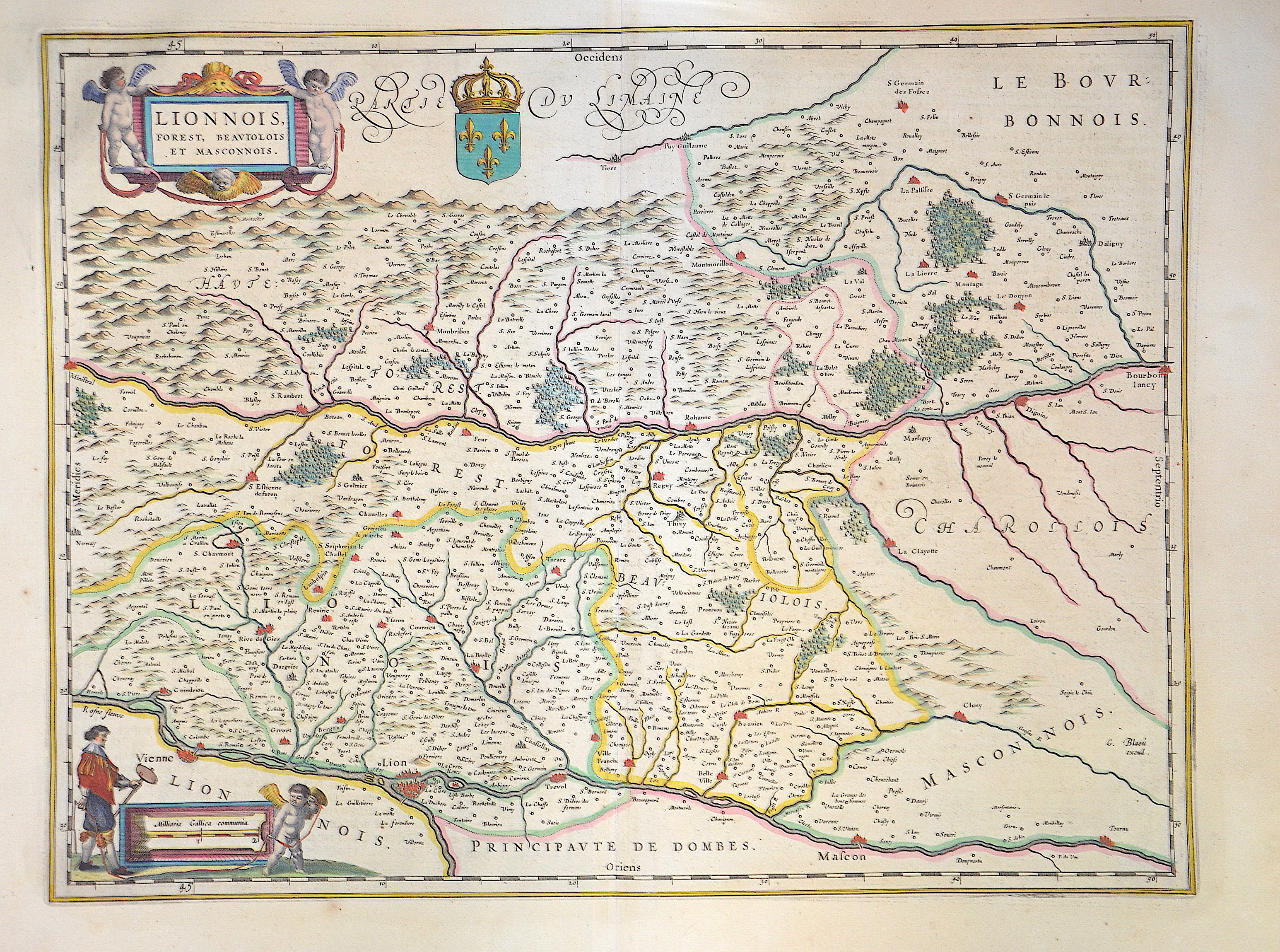
Lionnais, Forest, Beauiolois et Masconnois.

| Article ID | EUF1620 |
Title | Lionnais, Forest, Beauiolois et Masconnois. |
Description | Map shows the historical province of Lyonnais in France with a title cartouche, a mileage indicator cartouche, a heraldic representation as well as the city of Lyon and much more. Today, Lyonnais is located in the department of Rhône and partly belongs to the metropolis of Lyon. |
| Year | ca. 1610 |
Artist | Blaeu (1571-1638) |
Joan Guilliemus Blaeu was the eldest son of Willem Janszoon Blaeu (1571-1638), and was probably born in Alkmaar in the province of Noord-Holland in the final years of the 16th century. He was brought up in Amsterdam, and studied law at the University of Leiden before going into partnership with his father in the 1630s. Although his father Willem had cartographic interests, having studied under the Danish astronomer Tycho Brahe and having manufactured globes and instruments, his primary business was as a printer. It was under the control of Joan that the Blaeu printing press achieved lasting fame by moving towards the printing of maps and expanding to become the largest printing press in Europe in the 17th century. By the 1660s the Theatrum Orbis Terrarum (or Atlas Maior as it had became known by this time) had expanded to between 9 and 12 volumes, depending on the language. With over 3,000 text pages and approximately 600 maps, it was the most expensive book money could buy in the later 17th century. The translation of the text from Latin into Dutch, English, German, French, and Spanish for several volumes created enormous work for those involved in typography and letterpress activities. It is estimated that over 80 men must have been employed full-time in the Blaeu printing house in Bloemgracht, not including engravers who worked elsewhere, with over 15 printing presses running simultaneously, and in 1667 a second press was acquired at Gravenstraat. At the same time as producing the Atlas Maior, Blaeu was also publishing town plans of Italy, maps for globes, and other volumes. At its peak the Blaeu press managed to produce over 1 million impressions from 1,000 copper plates within four years. | |
Historical Description | Auvergne is one of the historical provinces of France. The name of the region is derived from the Arvernians, a Gaulish tribe that settled in the area at the time of the Roman conquest. In late antiquity, Auvergne was conquered by the Visigoths under Eurich in the 70s of the 5th century and was absorbed into the Frankish Empire at the beginning of the 6th century. During the Middle Ages, four dominions emerged in Auvergne. In 1651, the county passed to Frédéric-Maurice de La Tour d'Auvergne, duc de Bouillon, who received Auvergne and Albret in exchange for the strategically much more important Sedan and Raucourt. His descendants were deposed during the French Revolution. In 1790, the historic province was divided into the current departments. The departments of Haute-Loire and Allier also include parts of the historical provinces of Bourbonnais, Lyonnais and Languedoc. |
| Place of Publication | Amsterdam |
| Dimensions (cm) | 38 x 49,50 cm |
| Condition | Perfect condition |
| Coloring | original colored |
| Technique | Copper print |