

Adina Sommer
Antique and Contemporary Art
Winzerer Str. 154
80797 München
telephone
+49 89 304714
business hours:
by appointment
Email
![]()


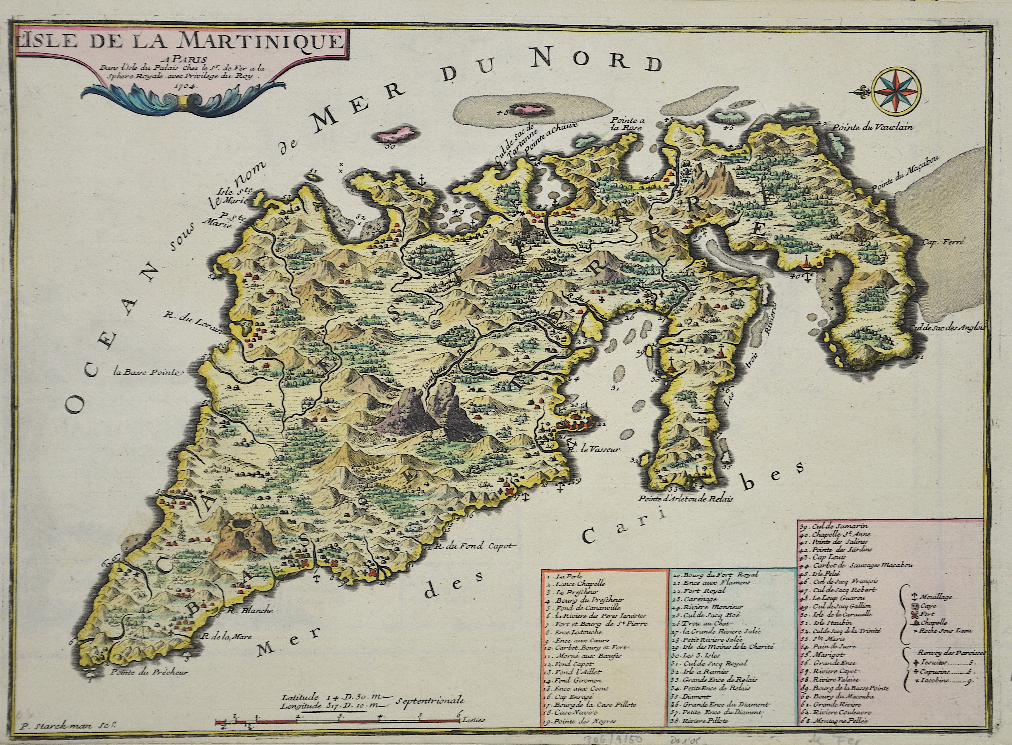
L´ile de la Martinique

| Article ID | AMW0554 |
Title | L´ile de la Martinique |
Description | Map shows the island Martinique |
| Year | dated 1704 |
Artist | Fer, de (1646-1720) |
Nicolas de Fer ( 1646 - 1720 in Paris) was a French cartographer and geographer. He also was an engraver and publisher. De Fer was the youngest of three sons of Antoine de Fer, who was also a cartographer. When he was 12, he became the apprentice of Parisian engraver Louis Spirinx, and made his first map, of the Canal du Midi, at the age of 23. After the death of his father in June 1673, de Fer was so successful at improving the firm that, in 1690, he became the official geographer to Louis, Dauphin of France. With support from the Spanish and French Royal Families, de Fer also became official geographer for Philip V and Louis XIV, the kings of Spain and France, respectively. Because of this, his maps became Bourbon propaganda, endorsing French King Louis XIV. His business flourished, producing town plans, atlases, wall maps, and more than 600 sheet maps.He made maps of places in Europe and North America, including New Spain, places fortified by Vauban, the Low Countries, and the War of the Spanish Succession. In 1698, de Fer published a map of North America, which included a depiction of beavers building dams near Niagara Falls. Seventeen years later, Herman Moll published an identical map as his own, known as the -Beaver map-. De Fer became the official geographer for His Catholic Majesty in 1720.Two of his sons-in-law, Guillaume Danet and Jaques-François Bénard, continued the company after de Fer's death on 25 October of that year until around 1760. | |
Historical Description | The island was colonized by France in 1635 by Pierre Belain d’Esnambuc on behalf of the Compagnie des îles d'Amérique founded by Richelieu and has remained in French possession until then, except for three short periods of foreign occupation. With the foundation of the French East India Company by Jean-Baptiste Colbert in 1664, Martinique became the property of the French crown. During the Second Anglo-Dutch War, France was allied with the Netherlands - an English fleet repeatedly attacked French settlements on Martinique and defeated a French squadron at Saint-Pierre on July 6th. In the Third Anglo-Dutch War, in which France was now fighting England against the Netherlands, Martinique was attacked on July 16, 1674 by the fleet of the Dutch admiral Michiel de Ruyter. Thanks to the patronage of Madame de Pompadour, the economist and physiocrat Pierre-Paul Le Mercier de La Rivière was appointed director or governor of Martinique, during the period from 1759 to 1764 he had great economic success there. From 1762 to 1763 Martinique was occupied by the British. In 1763, Joséphine, born de Tascher de la Pagerie, who later became Napoleon's wife, was born in Trois-Îlets near Fort-de-France in Martinique. Her parents ran a sugar cane plantation there, which can still be visited as a museum. From 1787 to 1802 a civil war broke out due to conflicts between plantation owners and traders, there was a slave uprising. In 1794, in the spirit of the French Revolution, the French convention voted for the abolition of slavery. This decision did not last long, however, because Napoleon reintroduced slavery in 1802. On May 22, 1848, slavery was finally abolished. Victor Schoelcher played an important role in this. From then on, Indians and Chinese were employed there due to a shortage of workers on the plantations. |
| Place of Publication | Paris |
| Dimensions (cm) | 26 x 35,50 |
| Condition | Upper margin perfectly replaced |
| Coloring | original colored |
| Technique | Copper print |