

Adina Sommer
Antique and Contemporary Art
Winzerer Str. 154
80797 München
telephone
+49 89 304714
business hours:
by appointment
Email
![]()


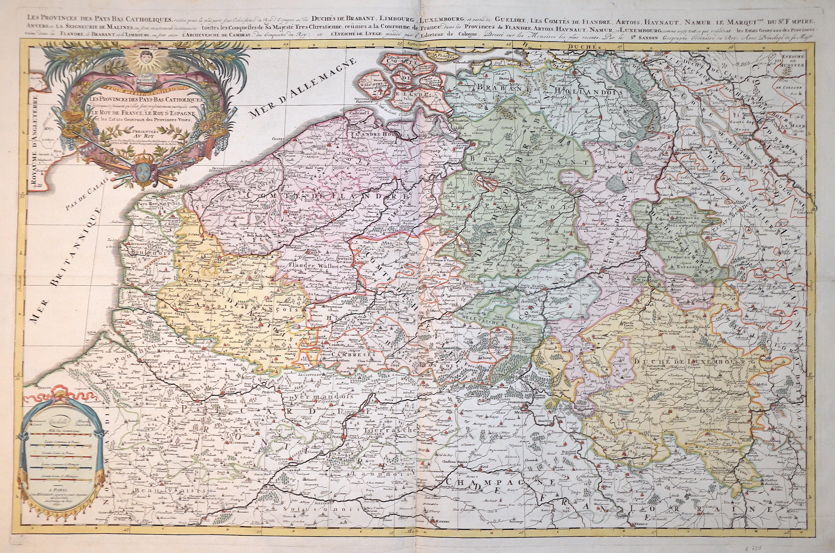
Les provinces des Pay Bas Catholiques…..le Roiyde France, le Roy d´ Espagne….

| Article ID | EUN2319 |
Title | Les provinces des Pay Bas Catholiques…..le Roiyde France, le Roy d´ Espagne…. |
Description | Map shows the whole of Belgium, Luxembourg and partly France with splendid title cartouche and mileage scale cartouche. |
| Year | dated 1691 |
Artist | Sanson/ Jaillot, Charles Hubert (1600-1667) |
Nicolas Sanson (1600–1667) was a French cartographer, termed by some the creator of French geography, in which he's been called the father of French cartography. Active from 1627, Sanson issued his first map of importance, the ""Postes de France"", which was published by Melchior Tavernier in 1632. After publishing several general atlases himself he became the associate of Pierre Mariette, a publisher of prints. In 1647 Sanson accused the Jesuit Philippe Labbe of plagiarizing him in his Pharus Galliae Antiquae; in 1648 he lost his eldest son Nicolas, killed during the Fronde. Among the friends of his later years was the great Condé. He died in Paris on 7 July 1667. Two younger sons, Adrien (d. 1708) and Guillaume (d. 1703), succeeded him as geographers to the king. In 1692 Hubert Jaillot collected Sanson's maps in an Atlas nouveau. See also the 18th century editions of some of Sanson's works on Delamarche under the titles of Atlas de géographie ancienne and Atlas britannique; and the Catalogue des cartes et livres de géographie de Sanson (1702). | |
Historical Description | As the province of Belgica - a name introduced by Caesar - what is now Belgium experienced many rulers. From the High Middle Ages to the early modern period, the cities of Flanders with their cloth industries represented one of the two centers of the European economy. Politically, the individual territories came under the House of Burgundy, which was inherited by the Habsburgs in 1477. In 1579 the Catholic Union of Arras and the Calvinist-Protestant Union of Utrecht were formed. The provinces of the Union of Utrecht broke away from Spain in 1581 and founded the Republic of the Seven United Provinces, whose independence was recognized in the Peace of Westphalia of 1648 after the end of the Eighty Years War. The provinces of the Union of Arras, Flanders and Brabant were administered as the Spanish Netherlands by a Spanish governor. After the extinction of the Spanish Habsburgs (1700) and the resulting War of the Spanish Succession, the Austrian Netherlands came under the rule of the Austrian Habsburgs in 1714. As a result of the absolutist-centralistic efforts of the Austrian ruler Joseph II, the Brabant Revolution came in 1789 and the short-lived United Belgian States. Revolutionary France annexed the Austrian Netherlands between 1792 and 1794, followed by incorporation into the French Republic in 1795. At the Congress of Vienna (1815) the provinces were awarded to the Netherlands. After the Belgian Revolution, the country gained independence in 1830. |
| Place of Publication | Paris |
| Dimensions (cm) | 54,5 x 87,5 cm |
| Condition | Printed on 2 sheets joined together |
| Coloring | original colored |
| Technique | Copper print |