

Adina Sommer
Antique and Contemporary Art
Winzerer Str. 154
80797 München
telephone
+49 89 304714
business hours:
by appointment
Email
![]()


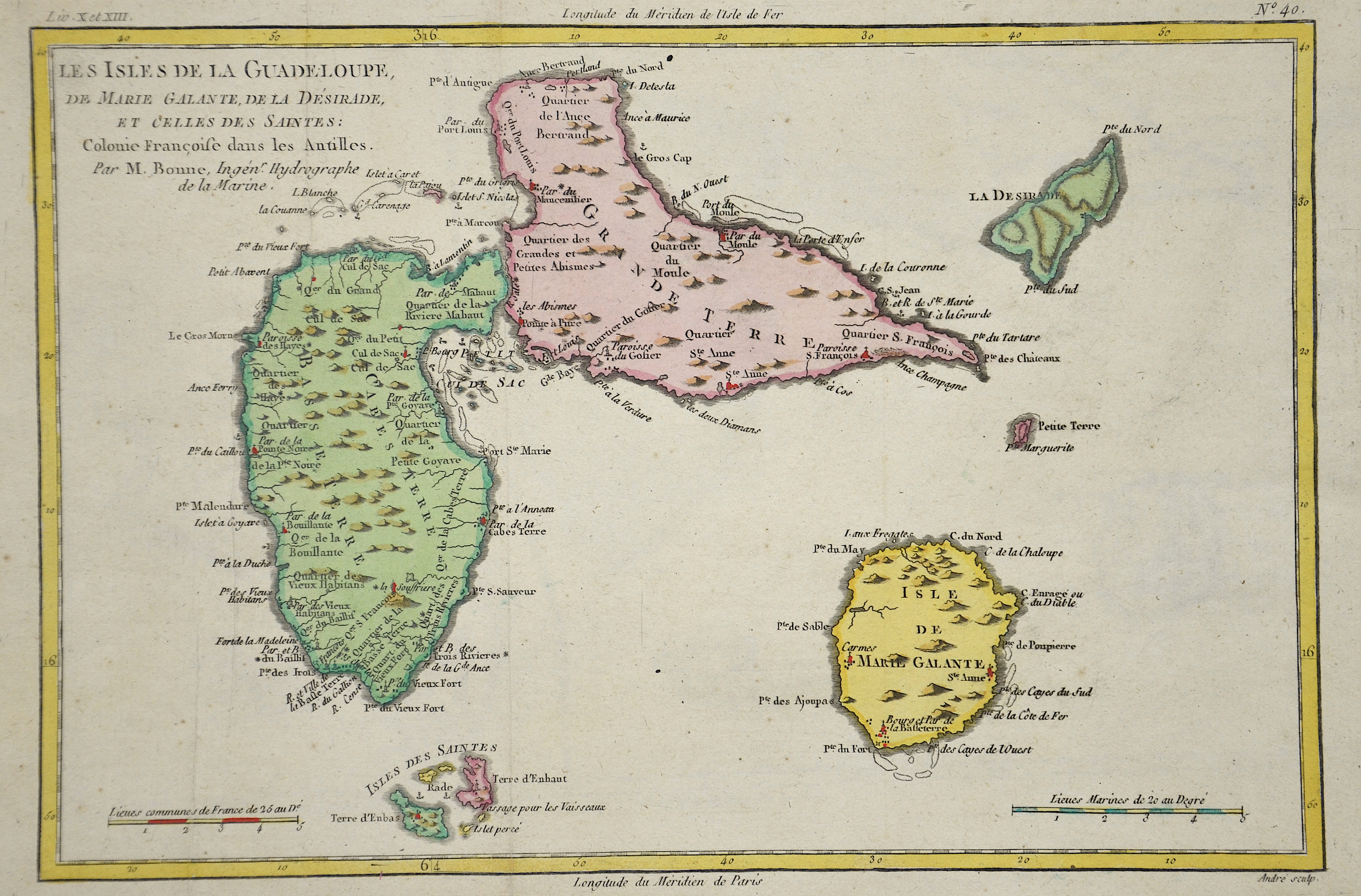
Les isles de la Guadeloupe, de Marie Galante, de la Desirade, et Celles des Saintes

| Article ID | AMW0588 |
Title | Les isles de la Guadeloupe, de Marie Galante, de la Desirade, et Celles des Saintes |
Description | Map shows the islands Guadeloupe and Marie Galante |
| Year | ca. 1710 |
Artist | Fer, de (1646-1720) |
Nicolas de Fer ( 1646 - 1720 in Paris) was a French cartographer and geographer. He also was an engraver and publisher. De Fer was the youngest of three sons of Antoine de Fer, who was also a cartographer. When he was 12, he became the apprentice of Parisian engraver Louis Spirinx, and made his first map, of the Canal du Midi, at the age of 23. After the death of his father in June 1673, de Fer was so successful at improving the firm that, in 1690, he became the official geographer to Louis, Dauphin of France. With support from the Spanish and French Royal Families, de Fer also became official geographer for Philip V and Louis XIV, the kings of Spain and France, respectively. Because of this, his maps became Bourbon propaganda, endorsing French King Louis XIV. His business flourished, producing town plans, atlases, wall maps, and more than 600 sheet maps.He made maps of places in Europe and North America, including New Spain, places fortified by Vauban, the Low Countries, and the War of the Spanish Succession. In 1698, de Fer published a map of North America, which included a depiction of beavers building dams near Niagara Falls. Seventeen years later, Herman Moll published an identical map as his own, known as the -Beaver map-. De Fer became the official geographer for His Catholic Majesty in 1720.Two of his sons-in-law, Guillaume Danet and Jaques-François Bénard, continued the company after de Fer's death on 25 October of that year until around 1760. | |
Historical Description | Columbus was the first European to reach the island on the outward journey of his second voyage in 1493. He named it Guadalupe after the Spanish pilgrimage site Nuestra Señora de Guadalupe, as he had promised the monks there that he would name an island. The Caribs initially defended themselves successfully against the Spaniards. It was not until 1635 that the French succeeded in colonizing Guadeloupe. In 1664 the island was transferred to the French West India Company. After its dissolution in 1674, the French crown took over the administration of the colony. The French colonial rulers established a plantation economy. They mainly grew sugar cane and coffee. The new masters had people brought from Africa as workers, who were deported to the New World in the context of the transatlantic slave trade with slave ships. In the course of the French Revolution of 1789, slavery was abolished in the French colonies and thus also in Guadeloupe in February 1794. Great Britain took advantage of the new political situation and occupied the islands in April 1794. It was supported by the plantation owners who wanted to prevent the implementation of the declared abolition of slavery. The British occupation, however, was soon driven out by French troops led by the National Commissioner for Guadeloupe, Victor Hugues. This also relied on the support of the freed slaves. Hugues ruled the islands as commissioner from 1794 to 1798. In 1946 Guadeloupe became the overseas department (Département d'Outre Mer / DOM) of France. It has not been a colony since then; it is regarded in all areas as an integral part of the mother country and its inhabitants are state side as French. |
| Place of Publication | Paris |
| Dimensions (cm) | 21,5 x 32 |
| Condition | Very good |
| Coloring | original colored |
| Technique | Copper print |