

Adina Sommer
Antique and Contemporary Art
Winzerer Str. 154
80797 München
telephone
+49 89 304714
business hours:
by appointment
Email
![]()


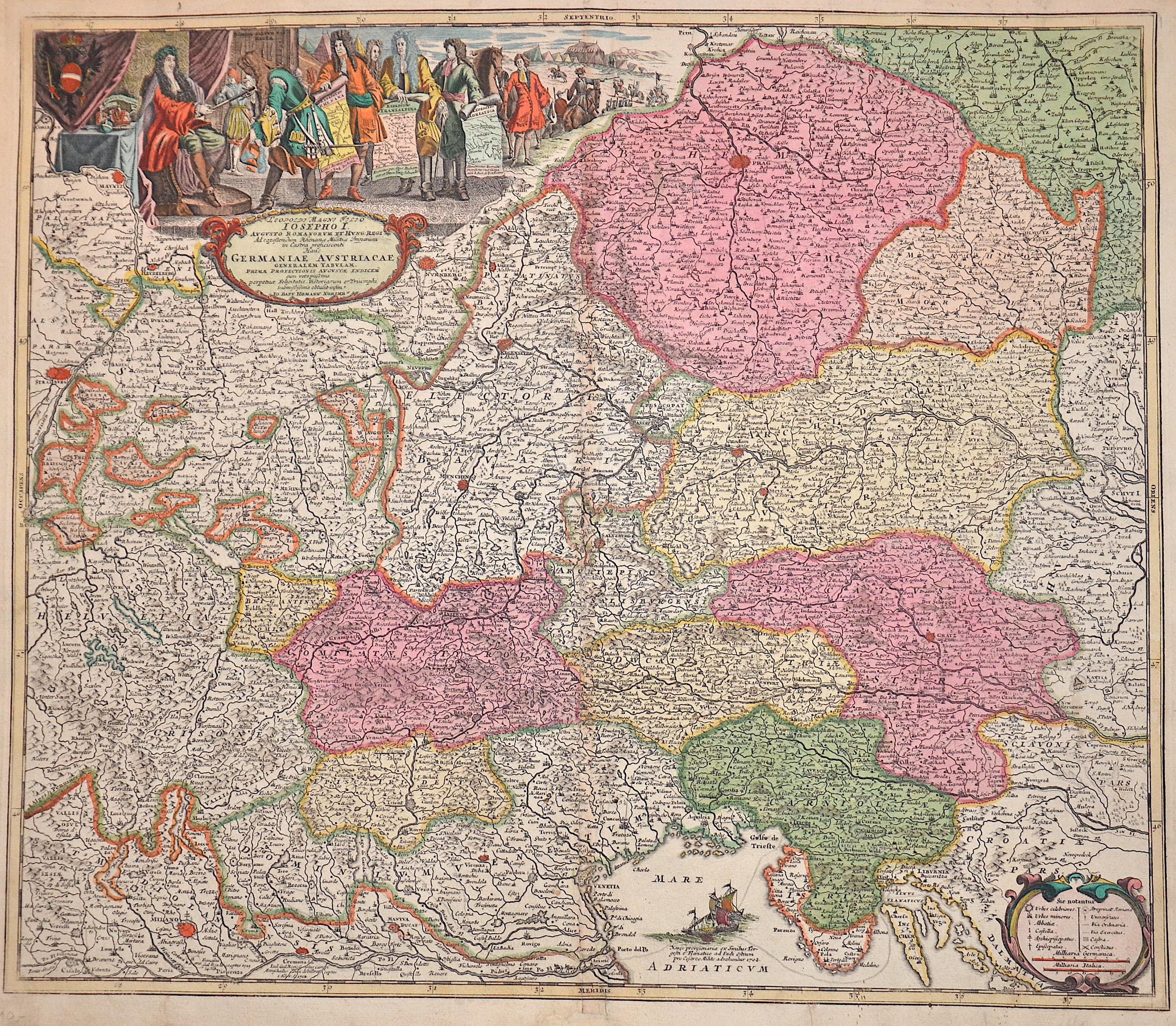
Leopoldi Magni Filio Josepho I. Augusto Romanorum et Hung. Regi.. Germaniae Austriacaie Generalem Tabulam,..

| Article ID | EUX5304 |
Title | Leopoldi Magni Filio Josepho I. Augusto Romanorum et Hung. Regi.. Germaniae Austriacaie Generalem Tabulam,.. |
Description | Map shows the area of Strasbourg, Milan, Ulm, Munich, Regensburg, Nuremberg, Insbruck, Brixen, Trento, Venice, Prague, Linz, Salzburg, Vienna, Bratislava (Pressburg), Klagenfurt, Gratz, Laibach and many more. Furthermore, a title cartouche with three small partial maps, a ship scene in the Adriatic and an index. Title translated from Latin: "Leopold the Great, son of Joseph I, Augustus of the Romans and Hungary. For the king who marched into camp to take command of the Rhineland militia, this general map of Austrian Germany,.." |
| Year | ca. 1697 |
Artist | Homann (1664-1724) |
Johann Babtiste Homann (1664-1724), Nuremberg, was born in Oberkammlach, the Electorate of Bavaria. Although educated at a Jesuit school, and preparing for an ecclesiastical career, he eventually converted to Protestantism and from 1687 worked as a civil law notary in Nuremberg. He soon turned to engraving and cartography; in 1702 he founded his own publishing house. Homann acquired renown as a leading German cartographer, and in 1715 was appointed Imperial Geographer by Emperor Charles VI. Giving such privileges to individuals was an added right that the Holy Roman Emperor enjoyed. In the same year he was also named a member of the Prussian Academy of Sciences in Berlin. Of particular significance to cartography were the imperial printing privileges (Latin: privilegia impressoria). These protected for a time the authors in all scientific fields such as printers, copper engravers, map makers and publishers. They were also very important as a recommendation for potential customers. In 1716 Homann published his masterpiece Grosser Atlas ueber die ganze Welt (Grand Atlas of all the World). Numerous maps were drawn up in cooperation with the engraver Christoph Weigel the Elder, who also published Siebmachers Wappenbuch. Homann died in Nuremberg. He was succeeded by the Homann heirs company, which was in business until 1848. The company was known as Homann Erben, Homanniani Heredes, or Heritiers de Homann abroad. | |
Historical Description | Various kingdoms are highlighted, most of which were under the rule of Leopold I. In the cartouche, Leopold is depicted as a ruler, with courtiers gathered around him. There is an explanatory text at the bottom of the map. According to this, the Rhine map shows the course of the front, the Savoy map the march of troops across the Alps and the Adriatic map the route of the army. |
| Place of Publication | Nuremberg |
| Dimensions (cm) | 49 x 56 cm |
| Condition | Restoration at centerfold |
| Coloring | original colored |
| Technique | Copper print |