

- Alsace
- Aquitaine
- Auvergne
- Bourgogne
- Bourgogne-Franche-Comte
- Brittany
- Centre
- Champagne
- France Islands
- Gascogne
- Gironde
- Hauts-de-France
- Ile de France
- Languedoc
- Lothringen
- Midi-Pyrénées
- Nivernais
- Nord-Pas-de-Calais
- Normandie
- Occitanie
- Pas-de-Calais
- Pays de la Loire
- Picardie
- Poitou-Charentes
- Provence-Alpes-Cote d Azur
- Pyrénées
- Rhone- Alpes
- Saintonge
- Savoyen
- Tourain
- Westcoast
Adina Sommer
Antique and Contemporary Art
Winzerer Str. 154
80797 München
telephone
+49 89 304714
business hours:
by appointment
Email
![]()


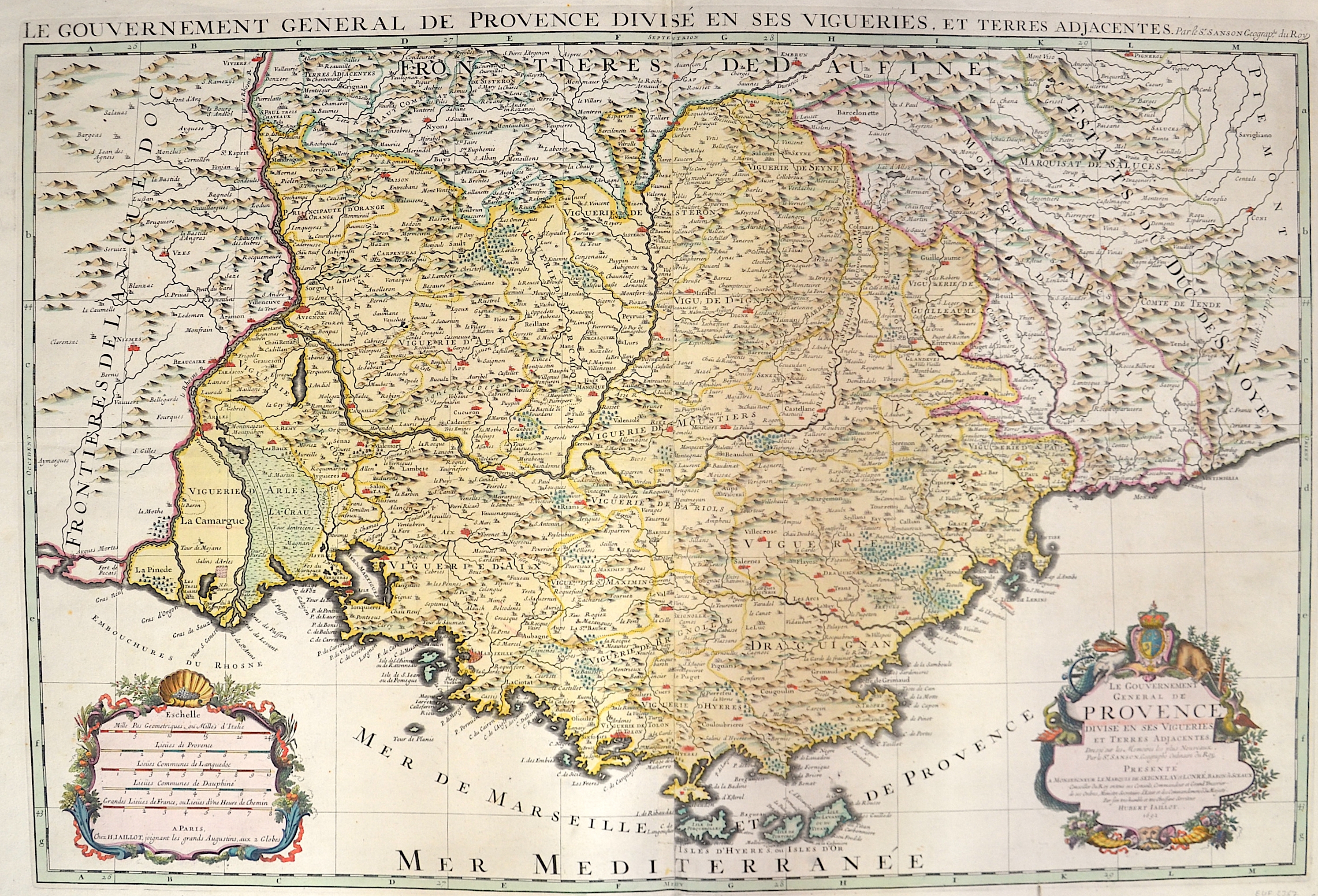
Le gouvernement general de Provence divise en ses vigueries, et Terres adjacentes

| Article ID | EUF2367 |
Title | Le gouvernement general de Provence divise en ses vigueries, et Terres adjacentes |
Description | Map shows the whole of Provence with Marseille and two magnificent cartouches. |
| Year | dated 1692 |
Artist | Sanson (1600-1667) |
Nicolas Sanson (1600–1667) was a French cartographer, termed by some the creator of French geography, in which he's been called the father of French cartography. Active from 1627, Sanson issued his first map of importance, the ""Postes de France"", which was published by Melchior Tavernier in 1632. After publishing several general atlases himself he became the associate of Pierre Mariette, a publisher of prints. In 1647 Sanson accused the Jesuit Philippe Labbe of plagiarizing him in his Pharus Galliae Antiquae; in 1648 he lost his eldest son Nicolas, killed during the Fronde. Among the friends of his later years was the great Condé. He died in Paris on 7 July 1667. Two younger sons, Adrien (d. 1708) and Guillaume (d. 1703), succeeded him as geographers to the king. In 1692 Hubert Jaillot collected Sanson's maps in an Atlas nouveau. See also the 18th century editions of some of Sanson's works on Delamarche under the titles of Atlas de géographie ancienne and Atlas britannique; and the Catalogue des cartes et livres de géographie de Sanson (1702). | |
Historical Description | Around 600 BC began the systematic colonization of the coast of Provence by Greeks from the Asia Minor city of Phocaea. The Phocaeans had come under pressure from the Persians and, during their voyages along the Mediterranean coast, had discovered the port basin of the later city of Marseille, created by nature. There is a legend according to which the Celtic king Nann was looking for a husband for his daughter Gyptis and gave his daughter the free choice. She chose a beautiful Greek stranger. On this they are said to have founded the city of Marseilles, then Massalia (later Massilia). This city experienced a tremendous increase in population. The city slowly began to develop into a large trading settlement, trading even with the distant Celtic tribes in what is now northern Germany. Above all, the good location by the sea made Massalia so successful. After almost 600 years as a Roman province, the land was conquered by the Visigoths in 470/477. From 934 on, Provence belonged to the united Kingdom of Burgundy, and from 1032 to the Holy Roman Empire due to an inheritance treaty that came to fruition. In 1498, the part of Provence that belonged to France at that time was incorporated into the Domaine royal, from 1660 the territory was administered like a province and in 1789, in the course of the French Revolution, it was divided into departments. Only the parts of Provence located in the Maritime Alps (also called the Maritime Alps), which had become independent over time (for example, the County of Nice and the Principality of Monaco), remained with the Holy Roman Empire, and some of them joined France only later. |
| Place of Publication | Paris |
| Dimensions (cm) | 56,5 x 84 cm |
| Condition | Perfect condition |
| Coloring | original colored |
| Technique | Copper print |