

Adina Sommer
Antique and Contemporary Art
Winzerer Str. 154
80797 München
telephone
+49 89 304714
business hours:
by appointment
Email
![]()


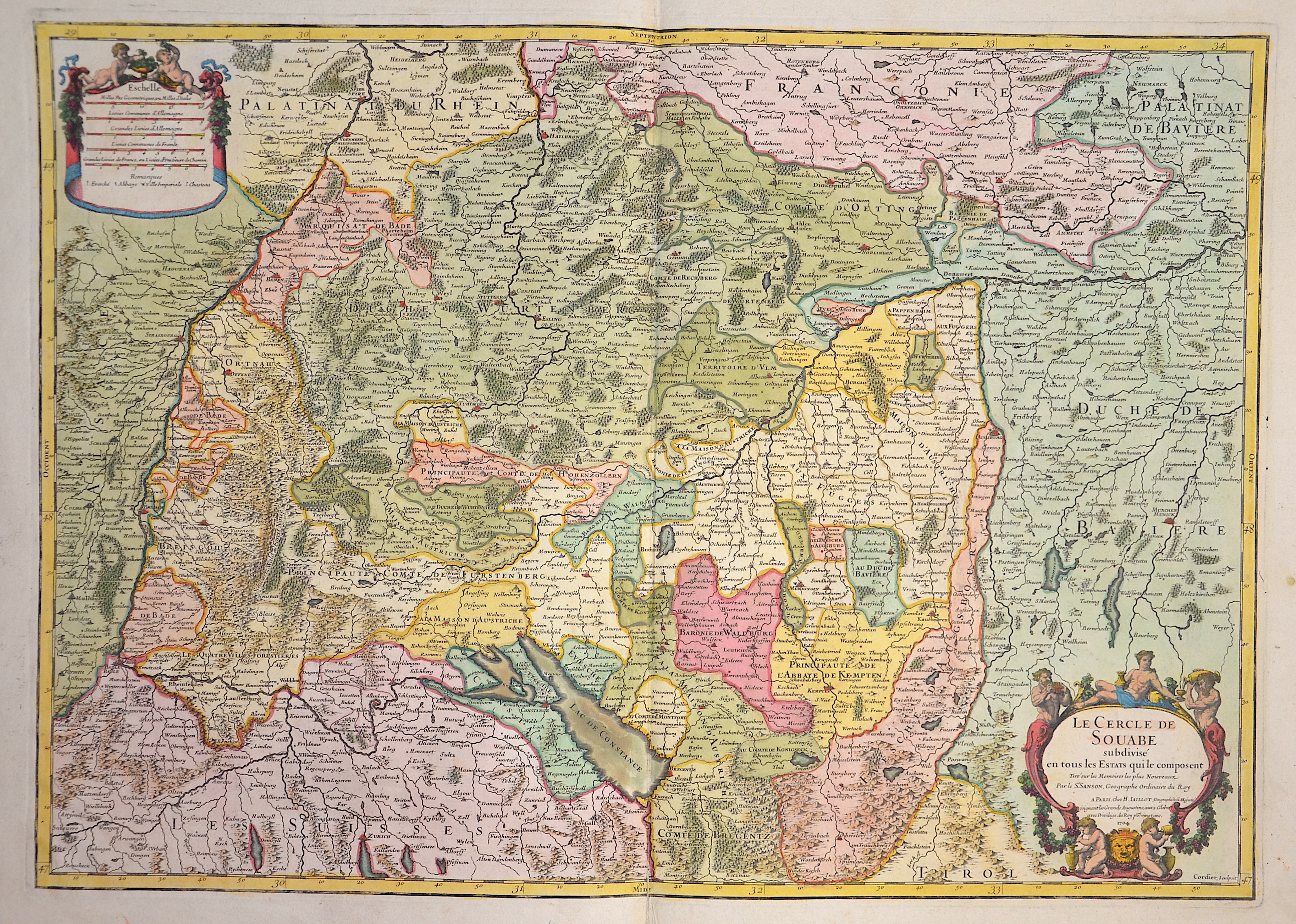
Le Cercle de Souabe subdivise en tous les Estats quile composent..

| Article ID | EUD4949 |
Title | Le Cercle de Souabe subdivise en tous les Estats quile composent.. |
Description | Magnificent old coloured map shows the whole of Swabia and Baden-Württemberg with the cities of Constance, Rottweil, Stuttgart, Lindau, Memmingen, Ulm, Augsburg with the surrounding countries and their cities Speyer, Strasbourg, Basel, Zurich, Obersdorf, Munich, Ingolstadt, Neuburg on the Danube, Neumarkt in der Oberpfalz and many more. Furthermore, a title and mileage indicator cartouche. |
| Year | c. 1704 |
Artist | Jaillot/ Sanson (1632-1712) |
Alexis Hubert Jaillot (1632–1712) was a prominent French cartographer and publisher. In 1665, he married into the Berey family of map publishers. After the death of his brother-in-law Nicolas II Berey in 1667, Jaillot bought the Berey map collection from his sister-in-law, acquiring a valuable stock without having ever created a map himself. Jaillot entered the map business at a favorable time—after Louis XIV’s early victories in the Reunions Wars in 1668, France’s territory expanded rapidly, creating high demand for maps showing French triumphs, new borders, and expansion plans. His collection included plates originally made by Pierre Duval, who resisted Jaillot’s reissues. At the height of this conflict, Jaillot gained the support of Guillaume and Adrien Sanson, sons of Nicolas Sanson, as mapmakers and partners, enabling him to publish new maps under the prestigious Sanson name. His first atlas, Atlas Nouveau (1681), was a commercial success, leading to widespread piracy by other publishers. | |
Historical Description | Baden-Wuertemberg is a state in southwest Germany, east of the Rhine, which forms the border with France. It is is formed from the historical territories of Baden, Prussian Hohenzollern, and Württemberg, and also parts of Swabia. Baden Würtemberg was only founded in 1952 by the merger of the states of Württemberg-Baden, Baden and Württemberg-Hohenzollern. Today the most populous city of Baden-Württemberg is the state capital Stuttgart, followed by Karlsruhe and Mannheim. Other major cities are Freiburg im Breisgau, Heidelberg, Ulm, Heilbronn, Pforzheim and Reutlingen. The early modern period was marked by the Reformation and the expansion efforts of the emerging states of Austria, Prussia, France and Sweden. Conflicts such as the Peasant War, the Thirty Years' War and the Palatinate War of Succession resulted from these. One of the focal points of the fighting, with corresponding consequences for the population and the economy, was in what is today Baden-Württemberg, which remained extremely fragmented territorially. At the beginning of the 19th century, around 300 states still had territorial rights in what is now Baden-Württemberg, but their number was reduced to four after the dissolution of the Old Empire. The Kingdom of Württemberg and the Grand Duchy of Baden were among the winners of the coalition wars. The two principalities of Hohenzollern-Sigmaringen and Hohenzollern-Hechingen survived mediatization due to their special relationship with Napoléon. In 1849, the Baden Revolution was put down by Prussian intervention forces, the Baden army was dissolved and rebuilt under Prussian leadership. In 1850 the two Hohenzollern states became the Prussian province of Hohenzollernsche Lande. With the new formation of the tribal duchies, the southern areas of what is now the state of Baden-Württemberg belonged to the Duchy of Swabia until the end of the High Middle Ages, the northern areas were located with the Duchy of Franconia. |
| Place of Publication | Paris |
| Dimensions (cm) | 45,5 x 64,5 cm |
| Condition | Some restoration at lower centerfold |
| Coloring | original colored |
| Technique | Copper print |