

Adina Sommer
Antique and Contemporary Art
Winzerer Str. 154
80797 München
telephone
+49 89 304714
business hours:
by appointment
Email
![]()


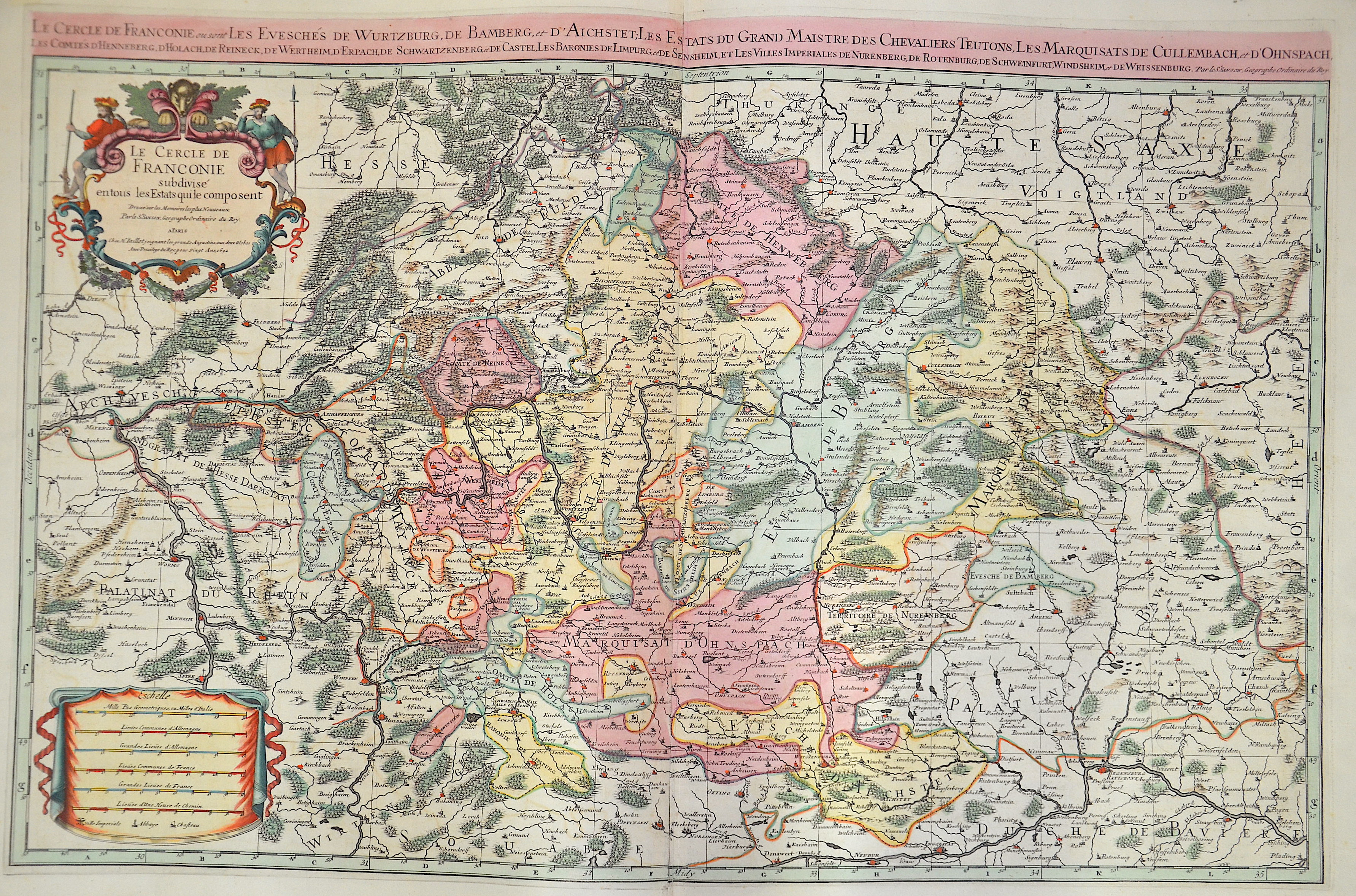
Le Cercle de Franconie ou sont les Eveschés de Wurtzburg, de Bamberg, et d’Aichstett,…

| Article ID | EUD3685 |
Title | Le Cercle de Franconie ou sont les Eveschés de Wurtzburg, de Bamberg, et d’Aichstett,… |
Description | Decorative an detailed map of Franconia in Bavaria with the cities of Koburg, Kulmbach, Neustadt, Würzburg, Schwäbisch Hall, Bamberg, Kronach, etc.and a nice cartouche. |
| Year | dated 1692 |
Artist | Sanson/ Jaillot, Charles Hubert (1600-1667) |
Nicolas Sanson (1600–1667) was a French cartographer, termed by some the creator of French geography, in which he's been called the father of French cartography. Active from 1627, Sanson issued his first map of importance, the ""Postes de France"", which was published by Melchior Tavernier in 1632. After publishing several general atlases himself he became the associate of Pierre Mariette, a publisher of prints. In 1647 Sanson accused the Jesuit Philippe Labbe of plagiarizing him in his Pharus Galliae Antiquae; in 1648 he lost his eldest son Nicolas, killed during the Fronde. Among the friends of his later years was the great Condé. He died in Paris on 7 July 1667. Two younger sons, Adrien (d. 1708) and Guillaume (d. 1703), succeeded him as geographers to the king. In 1692 Hubert Jaillot collected Sanson's maps in an Atlas nouveau. See also the 18th century editions of some of Sanson's works on Delamarche under the titles of Atlas de géographie ancienne and Atlas britannique; and the Catalogue des cartes et livres de géographie de Sanson (1702). | |
Historical Description | The Franconia fell to today's Franconia region with their victories over the Alemanni and Thuringians in their core areas in the 6th century. After the Franconian divisions, the Francia orientialis from the areas of the dioceses of Mainz, Worms, Würzburg and Speyer was added, and later the diocese of Bamberg was added. In the 7th century, the Slavs began to populate the northeastern parts of the region from the east, since the areas of today's Upper Franconia were sparsely populated (Bavaria Slavica). Charlemagne developed the areas around the Main into a royal province. From the middle of the 9th century, the Duchy of the Tribes, one of the five Duchies of the Eastern Franconian Empire, was established. From the 12th century, the Nuremberg Castle was the seat of the castle county of Nuremberg. From around 1190, the burgrave was ruled by the Zollern, the Frankish line of the later Hohenzollern, who represented the German emperor in the 19th and 20th centuries. Franconia already played an important role for the kingship in the time of Rudolf von Habsburg, the Itineraries of the following kings attested to the favoritism of the Rhine-Main region. In 1376 the Swabian Association of Cities was founded, which later also included several Franconian imperial cities. In July 1500, during the reign of Emperor Maximilian I, the empire was divided into imperial circles in the course of the imperial reform movement, which led to the creation of the Franconian imperial circle in 1512. From today's perspective, the Franconian Imperial Circle is sometimes considered to be an important basis for the development of a Franconian sense of community that still exists today. Franconia played an important role in the expansion of Martin Luther's Reformation. From 1552, the margrave Albrecht Alcibiades tried to break the supremacy of the mighty imperial city of Nuremberg and to secularize the possessions of the princes in order to create a duchy that he ruled. Large areas of Franconia were finally devastated in the fighting until King Ferdinand I, with several dukes and princes, decided to subjugate Albrecht. In 1608, Protestant sovereigns united in the Reich to form the so-called Union. The Catholic side reacted in 1609 with a counter-alliance, the league. The contrasts between the two camps eventually led to the Thirty Years' War, which became the greatest burden of cohesion within the Franconian Empire. From 1803 the later Kingdom of Bavaria received large parts of Franconia with the main deputation of the Imperial Deputation under the pressure of Napoleon Bonaparte through secularization and mediatization. Through the Rhine Confederation, Bavaria, Württemberg, Baden and other areas became more closely linked to France, which disintegrated the Holy Roman Empire and the Franconian Empire in 1806. |
| Place of Publication | Paris |
| Dimensions (cm) | 56,5 x 86 cm |
| Condition | Printed on 2 sheets joined together |
| Coloring | original colored |
| Technique | Copper print |