

- Alsace
- Aquitaine
- Auvergne
- Bourgogne
- Bourgogne-Franche-Comte
- Brittany
- Centre
- Champagne
- France Islands
- Gascogne
- Gironde
- Hauts-de-France
- Ile de France
- Languedoc
- Lothringen
- Midi-Pyrénées
- Nivernais
- Nord-Pas-de-Calais
- Normandie
- Occitanie
- Pas-de-Calais
- Pays de la Loire
- Picardie
- Poitou-Charentes
- Provence-Alpes-Cote d Azur
- Pyrénées
- Rhone- Alpes
- Saintonge
- Savoyen
- Tourain
- Westcoast
Adina Sommer
Antique and Contemporary Art
Winzerer Str. 154
80797 München
telephone
+49 89 304714
business hours:
by appointment
Email
![]()


L´Asazia….
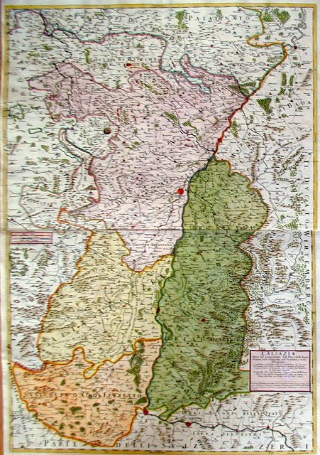

| Article ID | EUF1850 |
Title | L´Asazia…. |
Description | Map shows total Elsaß with Strassbourg with Breisgau |
| Year | dated 1690 |
Artist | Cantelli da Vignola (1643-1695) |
Giacomo Cantelli (1643–1695) studied literature in Bologna and later became secretary to the Marquis of Ferrara, Obizzi. He moved to Venice, where he gained recognition as a geographer, and likely traveled to Paris as part of a Venetian diplomatic mission to the court of Louis XIV. In Paris, he connected with cartographers such as Guillaume Sanson, Jacques-André Duval, and Michel-Antoine Baudrand. After returning to Italy, he served as secretary to Count Rinieri Marescotti in Bologna and traveled extensively, including to Rome, where he met publisher Giovanni Giacomo De Rossi. In 1672, De Rossi began publishing Cantelli’s maps, starting with the Holy Land, the Kingdom of Persia, and regions of the Ottoman Empire. In 1680–1681, Cantelli’s maps of Upper and Lower Lombardy appeared in the Mercury Geographic Atlas in Rome, showing strong influence from Giovanni Antonio Magini’s cartographic style. | |
Historical Description | The history of Alsace, a region on the western edge of the German-speaking area, is shaped by the fruitful influence of two of Europe's great cultural areas: Germanic (German) and Romance (French). After the Great Migration, it was first Germanised and incorporated into the cultural currents of German history. Since modern times it has increasingly come under the political control of the French kingdom. Various forms emerged here, the Duchy of Alsace (7th – 8th centuries), the two landgravates of Alsace (12th – 17th centuries) and the early modern French province of Alsace (17th – 18th centuries). Today's Alsace was first settled by humans around 700,000 years ago and was one of the core regions of the Celts. After a period of unclear and changing power relations, Alsace became part of Alemannia until the 7th century, which was a more or less autonomous administrative district of the Franconian Empire. In 988 at the latest, Alsace became part of the Duchy of Swabia, with which it remained until the end of 1250. After 1250, a large number of different territories developed, most of which came under French rule between 1633 and 1697/1714. The French province of Alsace was established, its borders partially differing from those of the earlier landgravates. At the beginning of the French Revolution, all special political rights were abolished in 1789 and the two departments of Haut-Rhin and Bas-Rhin were created in 1790. Between 1871 and 1918, Alsace, as part of Alsace-Lorraine, belonged to the German Empire, which was led by Prussia. In 1918 the two Alsatian districts came back to France as departments. |
| Place of Publication | Modena |
| Dimensions (cm) | 81,5 x 56 |
| Condition | Very good |
| Coloring | original colored |
| Technique | Copper print |