

Adina Sommer
Antique and Contemporary Art
Winzerer Str. 154
80797 München
telephone
+49 89 304714
business hours:
by appointment
Email
![]()


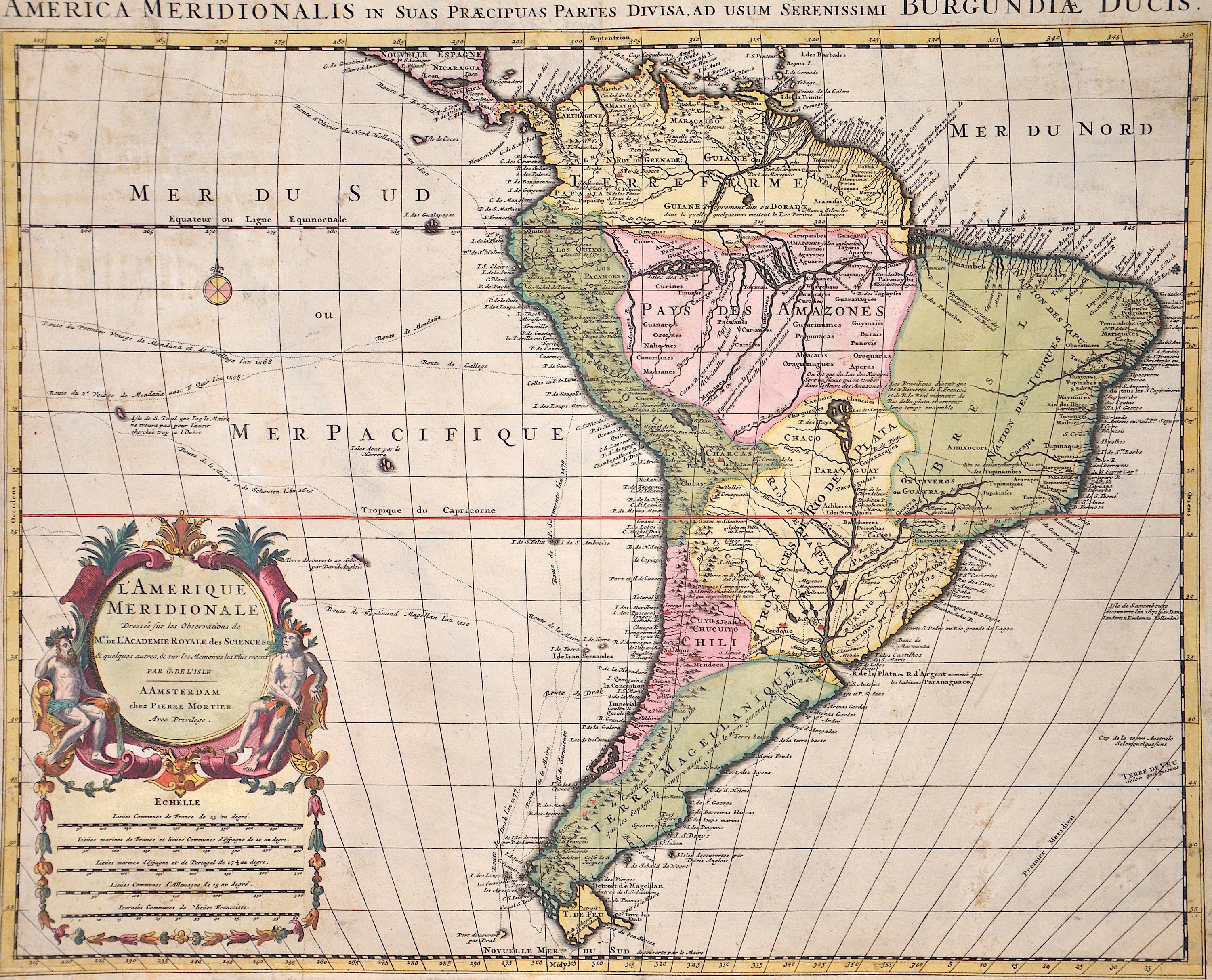
L’Amerique Meridionale Dressee sur les Observations de..

| Article ID | AMS1580 |
Title | L’Amerique Meridionale Dressee sur les Observations de.. |
Description | Map shows the whole of South America with magnificent title cartouche, compass rose, mileage indicator and various shipping routes. |
| Year | ca. 1722 |
Artist | Mortier (1661-1711) |
Pieter Mortier (1661–1711) was an 18th-century mapmaker and engraver from the Northern Netherlands. Mortier had a partnership with Johannes Covens I (1697-1774) and founded the map publishing company Covens & Mortier (1721-1866). Mortier, being French himself, had easy access to French cartographers such as De L'Isle, Sanson, Jaillot, de Fer and De Wit. Consequently, much of Mortier's business was built upon leveraging the sophisticated Dutch printing establishment to issue embellished high quality editions of previously contemporary French maps. In the greater context of global cartography, this was a significant advantage as most Dutch map publishes had, at this point, fallen into the miasma of reprinting their own outdated works. By contrast, the cartographers of France were producing the most accurate and up to date charts anywhere. Mortier's cartographic work culminated in the magnificent nautical atlas, Le Neptune Francois. Upon Pierre's death in 1711 this business was inherited by his widow. In 1721 his son Cornelius Mortier took over the day to day operation of the firm. Cornelius partnered with his brother-in-law Jean Covens to form one of history's great cartographic partnerships - Covens and Mortier - which continued to publish maps and atlases until about 1866. | |
Historical Description | One of the earliest known South American civilizations was at Norte Chico, on the central Peruvian coast. Though a pre-ceramic culture, the monumental architecture of Norte Chico is contemporaneous with the pyramids of Ancient Egypt. In 1494, Portugal and Spain, the two great maritime European powers of that time, on the expectation of new lands being discovered in the west, signed the Treaty of Tordesillas, by which they agreed, with the support of the Pope, that all the land outside Europe should be an exclusive duopoly between the two countries. Beginning in the 1530s, the people and natural resources of South America were repeatedly exploited by foreign conquistadors, first from Spain and later from Portugal. These competing colonial nations claimed the land and resources as their own and divided it in colonies. The Spaniards were committed to convert their native subjects to Christianity and were quick to purge any native cultural practices that hindered this end; however, many initial attempts at this were only partially successful, as native groups simply blended Catholicism with their established beliefs and practices. Furthermore, the Spaniards brought their language to the degree they did with their religion, although the Roman Catholic Church's evangelization in Quechua, Aymara, and Guaraní actually contributed to the continuous use of these native languages albeit only in the oral form. Guyana was first a Dutch, and then a British colony, though there was a brief period during the Napoleonic Wars when it was colonized by the French. The country was once partitioned into three parts, each being controlled by one of the colonial powers until the country was finally taken over fully by the British. The first South American country to abolish slavery was Chile in 1823, Uruguay in 1830, Bolivia in 1831, Colombia and Ecuador in 1851, Argentina in 1853, Peru and Venezuela in 1854, Paraguay in 1869, and in 1888 Brazil was the last South American nation and the last country in western world to abolish slavery. |
| Place of Publication | Amsterdam |
| Dimensions (cm) | 47 x 57,5 cm |
| Condition | Lower margin expertly restored, wormhole restored at upper left and right |
| Coloring | original colored |
| Technique | Copper print |