

Adina Sommer
Antique and Contemporary Art
Winzerer Str. 154
80797 München
telephone
+49 89 304714
business hours:
by appointment
Email
![]()


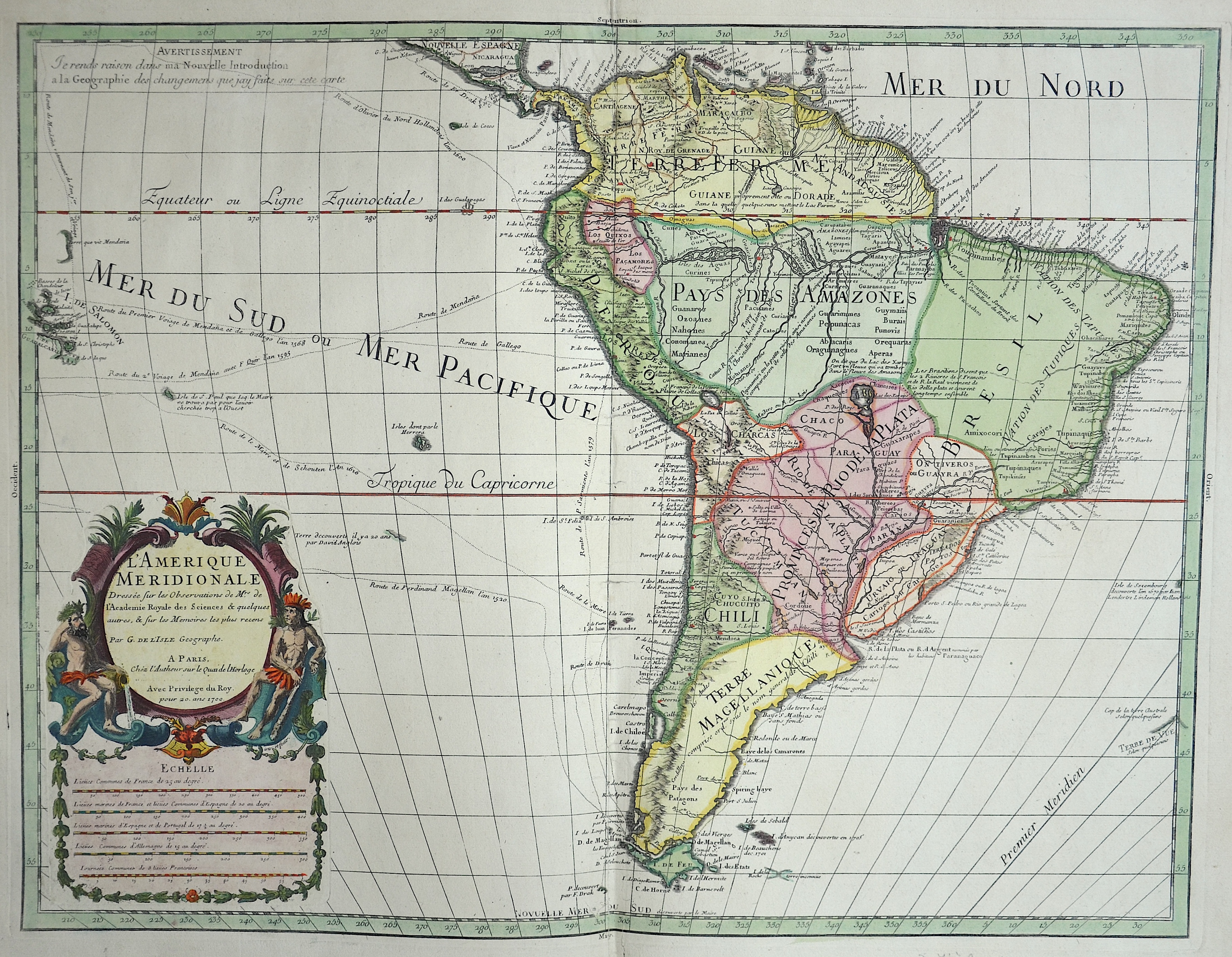
L’Amerique Meridionale

| Article ID | AMS1384 |
Title | L’Amerique Meridionale |
Description | Map shows the whole of South America with magnificent title cartouche, compass rose, mileage indicator and various shipping routes. |
| Year | c. 1700 |
Artist | De L´Isle (1675-1725) |
Guillaume de l'Isle was a French cartographer known for his popular and accurate maps of Europe and the newly explored Americas. At 27, Delisle was admitted into the French Académie Royale des Sciences, an institution financed by the French state. After that date, he signed his maps with the title of "Géographe de l’Académie". Five years later, he moved to the Quai de l’Horloge in Paris, a true publishing hub where his business prospered. Delisle's progress culminated in 1718 when he received the title of Premier Géographe du Roi. He was appointed to teach geography to the Dauphin, King Louis XIV’s son, a task for which he received a salary. Again, his father's reputation as a man of science probably helped the younger Delisle. Historian Mary Sponberg Pedley says, "once authority was established, a geographer's name might retain enough value to support two or three generations of mapmakers". He had drawn maps not only of European countries, such as Italy, Spain, Germany, Great Britain, Poland, and regions such as the Duchy of Burgundy, but he had also contributed to the empire's claims to recently explored continents of Africa and the Americas | |
Historical Description | One of the earliest known South American civilizations was at Norte Chico, on the central Peruvian coast. Though a pre-ceramic culture, the monumental architecture of Norte Chico is contemporaneous with the pyramids of Ancient Egypt. In 1494, Portugal and Spain, the two great maritime European powers of that time, on the expectation of new lands being discovered in the west, signed the Treaty of Tordesillas, by which they agreed, with the support of the Pope, that all the land outside Europe should be an exclusive duopoly between the two countries. Beginning in the 1530s, the people and natural resources of South America were repeatedly exploited by foreign conquistadors, first from Spain and later from Portugal. These competing colonial nations claimed the land and resources as their own and divided it in colonies. The Spaniards were committed to convert their native subjects to Christianity and were quick to purge any native cultural practices that hindered this end; however, many initial attempts at this were only partially successful, as native groups simply blended Catholicism with their established beliefs and practices. Furthermore, the Spaniards brought their language to the degree they did with their religion, although the Roman Catholic Church's evangelization in Quechua, Aymara, and Guaraní actually contributed to the continuous use of these native languages albeit only in the oral form. Guyana was first a Dutch, and then a British colony, though there was a brief period during the Napoleonic Wars when it was colonized by the French. The country was once partitioned into three parts, each being controlled by one of the colonial powers until the country was finally taken over fully by the British. The first South American country to abolish slavery was Chile in 1823, Uruguay in 1830, Bolivia in 1831, Colombia and Ecuador in 1851, Argentina in 1853, Peru and Venezuela in 1854, Paraguay in 1869, and in 1888 Brazil was the last South American nation and the last country in western world to abolish slavery. |
| Place of Publication | Paris |
| Dimensions (cm) | 45,5 x 60 cm |
| Condition | Perfect condition |
| Coloring | original colored |
| Technique | Copper print |