

Adina Sommer
Antique and Contemporary Art
Winzerer Str. 154
80797 München
telephone
+49 89 304714
business hours:
by appointment
Email
![]()


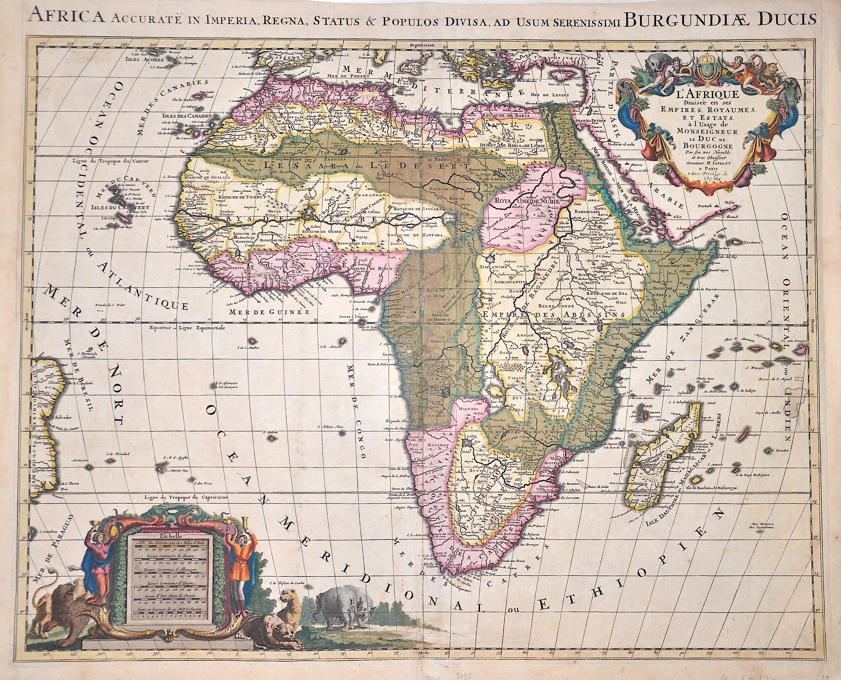
L’Afrique divisee en ses Empires, Royaumes, et Estats,

| Article ID | AF016 |
Title | L’Afrique divisee en ses Empires, Royaumes, et Estats, |
Description | Splendid old coloured map of the whole of Africa with Madagascar, a title cartouche and a mileage scale cartouche with inhabitants and animals of Africa. After Jaillot's map of 1674, which in turn is based on Sanson's map of 1668. Despite the title, this map was engraved by Pierre Mortier and published in Amsterdam. |
| Year | ca. 1694 |
Artist | Mortier (1661-1711) |
Pieter Mortier (1661–1711) was an 18th-century mapmaker and engraver from the Northern Netherlands. Mortier had a partnership with Johannes Covens I (1697-1774) and founded the map publishing company Covens & Mortier (1721-1866). Mortier, being French himself, had easy access to French cartographers such as De L'Isle, Sanson, Jaillot, de Fer and De Wit. Consequently, much of Mortier's business was built upon leveraging the sophisticated Dutch printing establishment to issue embellished high quality editions of previously contemporary French maps. In the greater context of global cartography, this was a significant advantage as most Dutch map publishes had, at this point, fallen into the miasma of reprinting their own outdated works. By contrast, the cartographers of France were producing the most accurate and up to date charts anywhere. Mortier's cartographic work culminated in the magnificent nautical atlas, Le Neptune Francois. Upon Pierre's death in 1711 this business was inherited by his widow. In 1721 his son Cornelius Mortier took over the day to day operation of the firm. Cornelius partnered with his brother-in-law Jean Covens to form one of history's great cartographic partnerships - Covens and Mortier - which continued to publish maps and atlases until about 1866. | |
Historical Description | According to the "Out-of-Africa theory", Africa is considered the "cradle of mankind", where homo development led to the development of the anatomically modern human Homo sapiens. One of the earliest advanced civilizations in mankind was formed in ancient Egypt. Over the millennia, various "great empires" such as the Empire of Abyssinia emerged on the continent. There were other kingdoms in West Africa, such as the Ashanti and Haussa, but they emerged much later. There were also some important cultures in East and South Africa, as in the area of today's Sudan, then called Nubia or Kush. Nubian pharaohs ruled all of Egypt for a dynasty. For example, the inhabitants of Greater Zimbabwe were important cultures in southern Africa. This stone castle was architecturally a masterpiece at that time and important for trade between the peoples of the south and east. The Swahili were known in East Africa. North Africa was connected to Europe and the Near East by the Mediterranean rather than separated. Carthage, a foundation of the Phoenicians in what is now Tunisia, was around the middle of the 1st millennium BC. The dominant power in the western Mediterranean until it was replaced by Rome in the Punic Wars. This prevailed from 30 BC. BC (conquest of Egypt) over all of North Africa. Even the ancient Egyptians (Queen Hatshepsut) made trips to Punt, probably in what is now Somalia. The kingdom of the Queen of Sheba, which probably had its center in southern Arabia, is said to have spanned parts of the Horn from Africa to the north of Ethiopia. |
| Place of Publication | Amsterdam |
| Dimensions (cm) | 57 x 88 cm |
| Condition | Restoration at centerfold and missing part replaced |
| Coloring | original colored |
| Technique | Copper print |
Reproduction:
135.00 €
( A reproduction can be ordered individually on request. )