

- Alsace
- Aquitaine
- Auvergne
- Bourgogne
- Bourgogne-Franche-Comte
- Brittany
- Centre
- Champagne
- France Islands
- Gascogne
- Gironde
- Hauts-de-France
- Ile de France
- Languedoc
- Lothringen
- Midi-Pyrénées
- Nivernais
- Nord-Pas-de-Calais
- Normandie
- Occitanie
- Pas-de-Calais
- Pays de la Loire
- Picardie
- Poitou-Charentes
- Provence-Alpes-Cote d Azur
- Pyrénées
- Rhone- Alpes
- Saintonge
- Savoyen
- Tourain
- Westcoast
Adina Sommer
Antique and Contemporary Art
Winzerer Str. 154
80797 München
telephone
+49 89 304714
business hours:
by appointment
Email
![]()


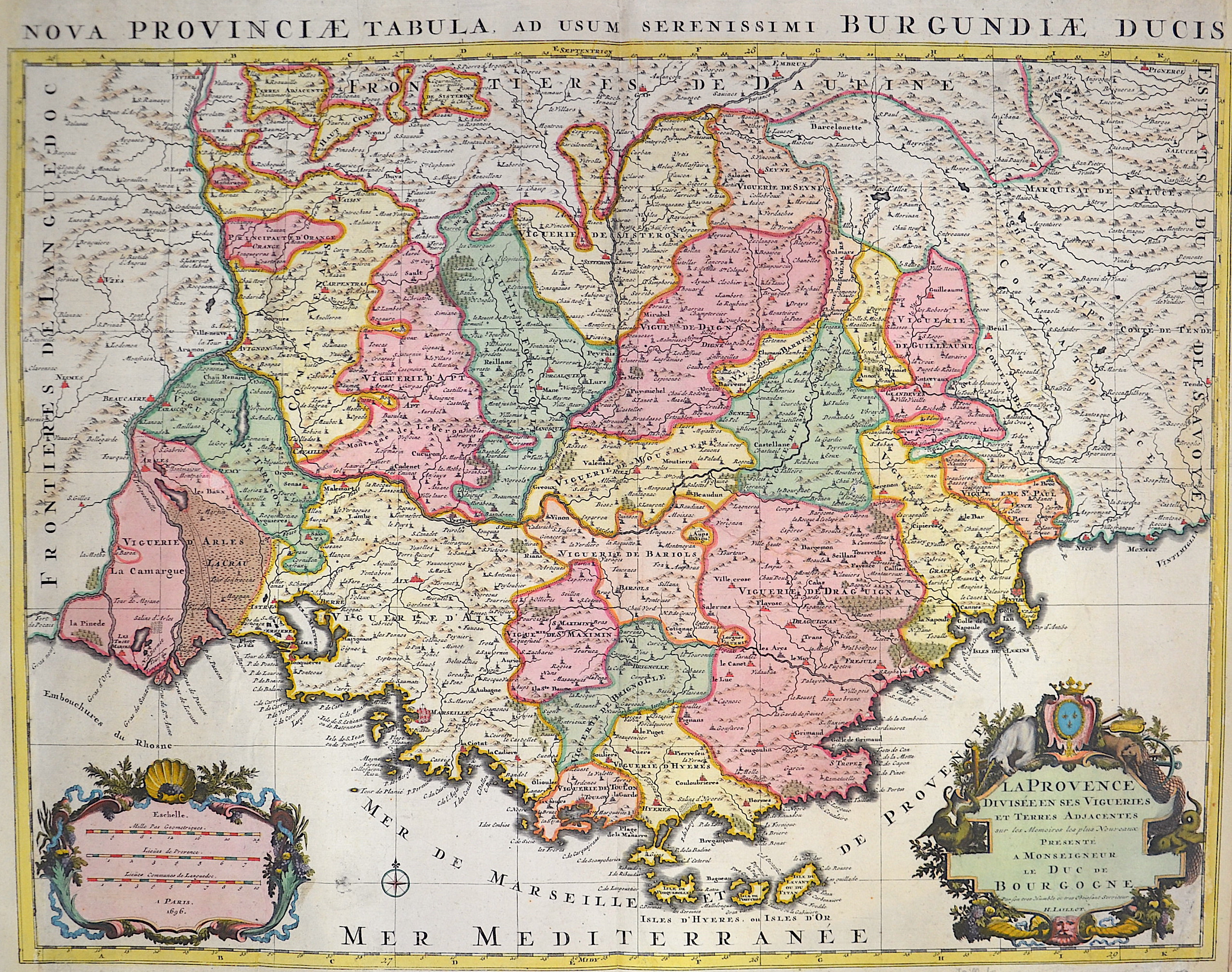
La Provence divisée en ses vigoeries et terres atjacentes….Duc de Burgogne

| Article ID | EUF1410 |
Title | La Provence divisée en ses vigoeries et terres atjacentes….Duc de Burgogne |
Description | Map shows the whole of Provence with two magnificent cartouches. |
| Year | ca. 1690 |
Artist | Jaillot (1632-1712) |
Alexis Hubert Jaillot (1632-1712) was an important French cartographer and publisher. In 1665 Jaillot married into the Berey family of map publishers. After the death of his brother-in-law Nicolas II Berey (1640–1667) he bought the Berey card collection from his sister-in-law. This gave him a valuable foundation that he could market straight away without ever having made a map himself. Jaillot entered the card business at an opportune moment. In early 1668, Louis XIV won the first of his Reunion Wars, and a period began when France was constantly expanding its territory. There was a great demand for maps depicting the French triumphs and the new frontiers, as well as upcoming expansion plans. Jaillot's map collection also included printing plates that Pierre Duval (1619–1683) (nephew of Nicolas Sanson) had created and originally sold to Nicolas Berey. But Duval, who also mislaid his cards himself, resisted the re-edition of his old cards. At the height of the dispute with Duval, Jaillot won Nicolas Sanson's sons Guillaume and Adrien in late 1670 as card makers and business partners. With them he was able to market new cards with the prestigious name Sansons. His first atlas of 1681, Atlas Nouveau, became such a great commercial success that other publishers began selling plagiarism. | |
Historical Description | Around 600 BC began the systematic colonization of the coast of Provence by Greeks from the Asia Minor city of Phocaea. The Phocaeans had come under pressure from the Persians and, during their voyages along the Mediterranean coast, had discovered the port basin of the later city of Marseille, created by nature. There is a legend according to which the Celtic king Nann was looking for a husband for his daughter Gyptis and gave his daughter the free choice. She chose a beautiful Greek stranger. On this they are said to have founded the city of Marseilles, then Massalia (later Massilia). This city experienced a tremendous increase in population. The city slowly began to develop into a large trading settlement, trading even with the distant Celtic tribes in what is now northern Germany. Above all, the good location by the sea made Massalia so successful. After almost 600 years as a Roman province, the land was conquered by the Visigoths in 470/477. From 934 on, Provence belonged to the united Kingdom of Burgundy, and from 1032 to the Holy Roman Empire due to an inheritance treaty that came to fruition. In 1498, the part of Provence that belonged to France at that time was incorporated into the Domaine royal, from 1660 the territory was administered like a province and in 1789, in the course of the French Revolution, it was divided into departments. Only the parts of Provence located in the Maritime Alps (also called the Maritime Alps), which had become independent over time (for example, the County of Nice and the Principality of Monaco), remained with the Holy Roman Empire, and some of them joined France only later. |
| Place of Publication | Paris |
| Dimensions (cm) | 47,5 x 61 cm |
| Condition | Left and right margin replaced, missing parts restored |
| Coloring | original colored |
| Technique | Copper print |