

Adina Sommer
Antique and Contemporary Art
Winzerer Str. 154
80797 München
telephone
+49 89 304714
business hours:
by appointment
Email
![]()


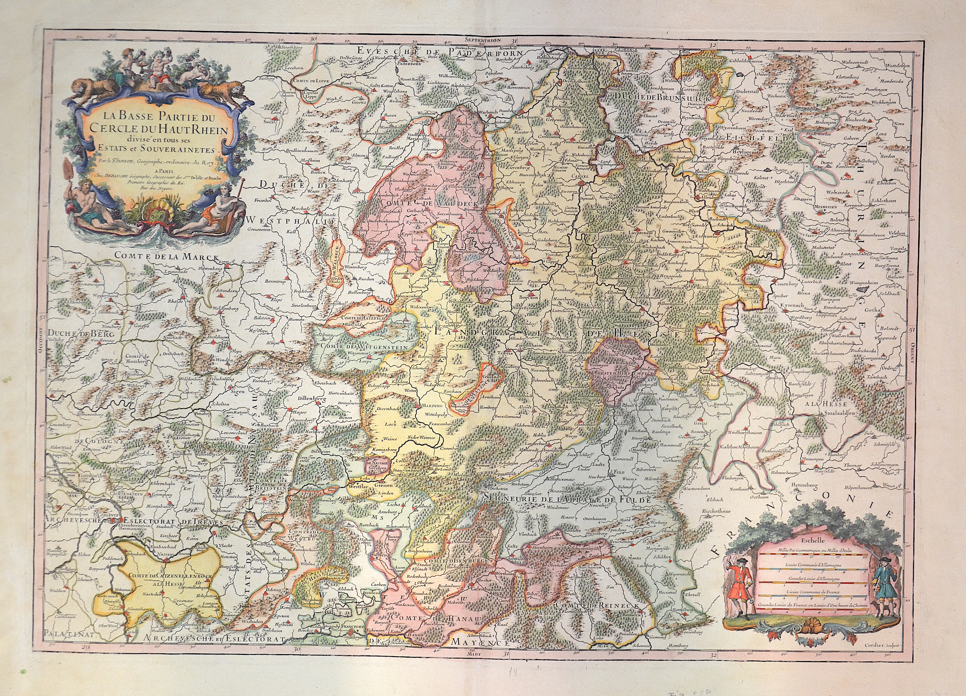
La Basse Partie Du Cercle Du Haute Rhein…

| Article ID | EUD0041 |
Title | La Basse Partie Du Cercle Du Haute Rhein… |
Description | Map of the Lower Rhine area in Hesse from Kassel to Frankfurt am Main and Koblenz. |
| Year | ca. 1710 |
Artist | Sanson (1600-1667) |
Nicolas Sanson (1600–1667) was a French cartographer, termed by some the creator of French geography, in which he's been called the father of French cartography. Active from 1627, Sanson issued his first map of importance, the ""Postes de France"", which was published by Melchior Tavernier in 1632. After publishing several general atlases himself he became the associate of Pierre Mariette, a publisher of prints. In 1647 Sanson accused the Jesuit Philippe Labbe of plagiarizing him in his Pharus Galliae Antiquae; in 1648 he lost his eldest son Nicolas, killed during the Fronde. Among the friends of his later years was the great Condé. He died in Paris on 7 July 1667. Two younger sons, Adrien (d. 1708) and Guillaume (d. 1703), succeeded him as geographers to the king. In 1692 Hubert Jaillot collected Sanson's maps in an Atlas nouveau. See also the 18th century editions of some of Sanson's works on Delamarche under the titles of Atlas de géographie ancienne and Atlas britannique; and the Catalogue des cartes et livres de géographie de Sanson (1702). | |
Historical Description | The history of Hesse in the 16th to 19th centuries was shaped by significant political, religious, and social changes. This period was marked by the Reformation, the Thirty Years' War, the Napoleonic Wars, and changes within the German Confederation. In the 16th century, Hesse was a state in the Holy Roman Empire. The Reformation began in Hesse in 1527, when Landgrave Philip the Magnanimous of Hesse became one of the first German princes to adopt the Lutheran faith. As a result, Hesse became a center of the Reformation, which brought profound religious and political changes to the region. In the 17th century, Hesse was affected by the Thirty Years' War (1618–1648). The war, which plunged Europe into a devastating conflict, also had catastrophic consequences for Hesse. In particular, the mid-century saw economic decline and social hardships. The Peace of Westphalia (1648) ended the war, but its economic and political repercussions were felt for a long time. In the 18th century, Hesse began to stabilize. The state was an important part of the Holy Roman Empire and was governed by the Landgraves of Hesse-Kassel. Hesse-Kassel was a prosperous region, particularly benefiting from tax revenues generated through trade in iron and salt. The early 19th century was shaped by the Napoleonic Wars and the resulting upheavals. In 1806, Hesse-Kassel joined the Confederation of the Rhine and came under French influence. After the end of the Napoleonic era and the decisions of the Congress of Vienna (1815), Hesse-Kassel came under the control of the House of Hesse again but became part of the German Confederation, a loose union of German states. In 1866, Hesse took part in the Austro-Prussian War and, after the conflict, was annexed by Prussia and integrated into the Prussian province of Hesse-Nassau. By the end of the 19th century, Hesse had become part of the newly unified German Empire, established in 1871 under Prussian leadership, and the region experienced a phase of industrialization and modernization. |
| Place of Publication | Paris |
| Dimensions (cm) | 46 x 65 |
| Condition | Very good |
| Coloring | original colored |
| Technique | Copper print |