

Adina Sommer
Antique and Contemporary Art
Winzerer Str. 154
80797 München
telephone
+49 89 304714
business hours:
by appointment
Email
![]()


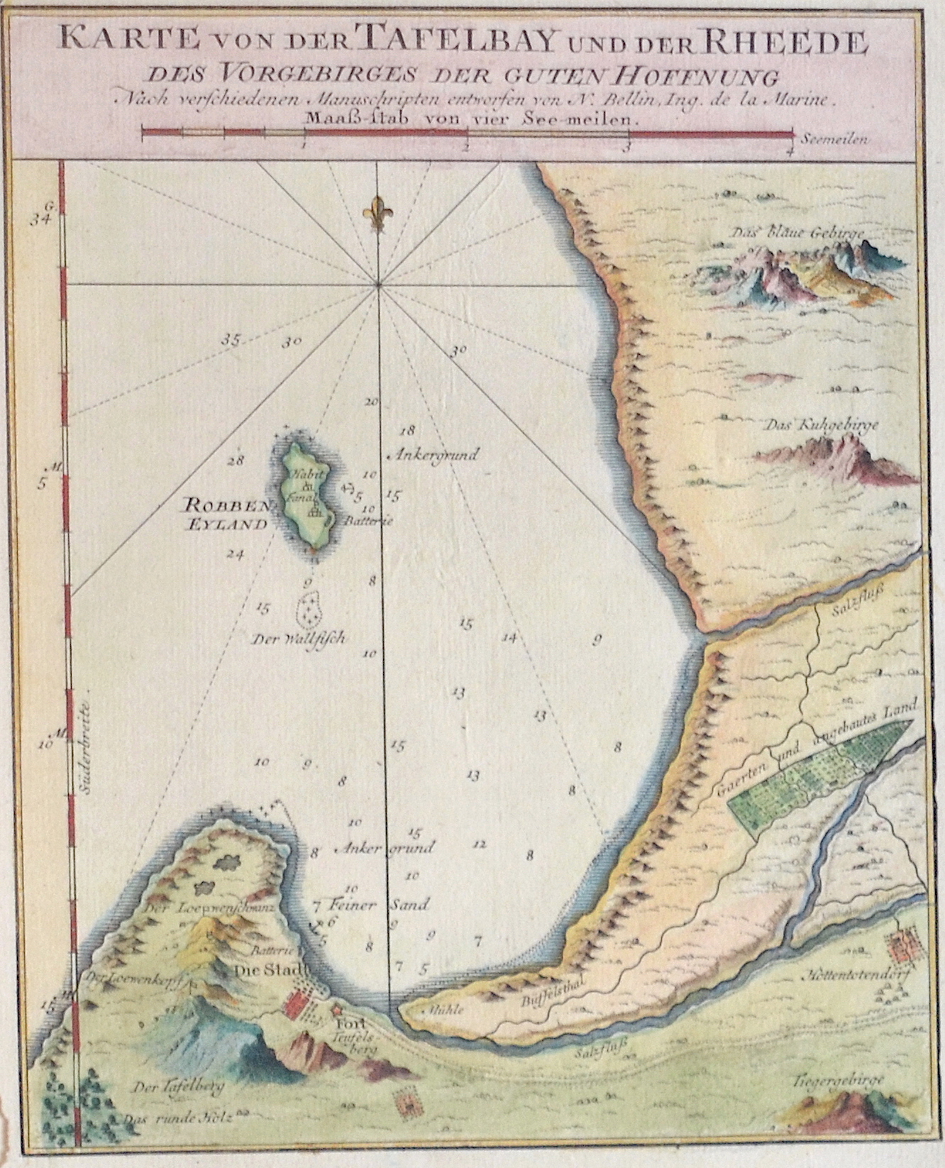
Karte von der Tafelbay und der Rheede des Vorgebirges der Guten Hoffnung

| Article ID | AF0427 |
Title | Karte von der Tafelbay und der Rheede des Vorgebirges der Guten Hoffnung |
Description | Map shows the Table Bay with Robben Island and the city of Capetown at the Cape of Good Hope with the towns landmark, the Table Mountain in South Africa. |
| Year | ca. 1740 |
Artist | Bellin (1703-1772) |
Jacques-Nicolas Bellin (1703 Paris -1772 Versailles) was a French cartographer, engineer-geographer, marine hydrographer. As a contributor to the Encyclopédie, he wrote more than a thousand articles on maritime topics. As a cartographer, Bellin distinguished himself primarily in the field of sea cartography. From 1721 he worked for the Dépot des Cartes et Plans de la Marine, from 1741 until his death as an engineer-hydrograph of the Navy. In 1753 his atlas Neptune français, which covered all the coasts of France, was published, and in 1756 the hydrography françoise covering all seas of the earth. In 1764 the five-volume Petit Atlas maritime was published, which Bellin prepared on the orders of the Minister of the Navy, Choiseul. In addition, he wrote a number of geographical works and with Nouvelle méthode pour apprendre la geographie (1769) a geographic textbook for teaching. His maps illustrated, among other things, Bougainville's work Voyage autour du monde, published in 1771. As a co-author of the Encyclopédie edited by Diderot and d'Alembert, Bellin wrote more than a thousand articles in the field of shipping and navy. | |
Historical Description | The Cape of Good Hope is a very striking cape near the southern tip of Africa that was once feared for its cliffs. Bartolomeo Diaz named the rocky headland that juts out more than 20 kilometers into the sea Cabo das Tormentas (Cape of Storms). The Portuguese King John II is said to have given it the new name because he rightly hoped that the sea route to India had now been discovered. After examining the few documents that still exist, historians today disagree as to whether Diaz had not already used the name Cabo da Boa Esperança (Cape of Good Hope). The Cape was first sighted by a European in April 1488 by the Portuguese navigator and explorer Bartolomeu Diaz, when he had already circumnavigated the southern tip of Africa (far from the coast) and was on his way back north. Diaz had set out with two caravels and a supply ship on a top-secret voyage of discovery in the summer of 1487. Because of the decreed secrecy of the voyage of discovery, no written records exist. With the opening of the Suez Canal in November 1869, the route around the southern tip of Africa suddenly lost its importance. |
| Place of Publication | Paris |
| Dimensions (cm) | 21 x 17 |
| Condition | Perfect condition |
| Coloring | original colored |
| Technique | Copper print |