

Adina Sommer
Antique and Contemporary Art
Winzerer Str. 154
80797 München
telephone
+49 89 304714
business hours:
by appointment
Email
![]()


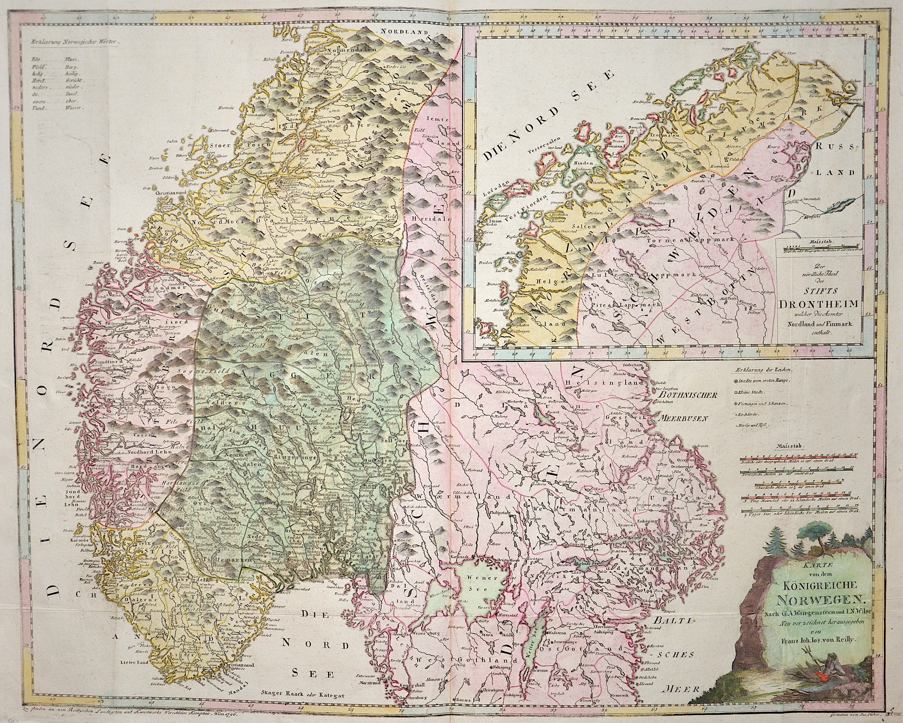
Karte von dem Königreiche Norwegen. Nach O. A. Wangensteen und I. N. Wilse Neu verzeichnet herausgegeben von Franz Joh.Jos. Von Reilly.

| Article ID | EUS5353 |
Title | Karte von dem Königreiche Norwegen. Nach O. A. Wangensteen und I. N. Wilse Neu verzeichnet herausgegeben von Franz Joh.Jos. Von Reilly. |
Description | Map showing Norway, partly Sweden, a inset map of Lapland with the title: "Der nördliche Theil des Stifts Drontheim..." (The northern part of the Diocese of Trondheim...), a title cartouche, and an explanation of Norwegian words in the top left corner. Author: O. A. Wangensteen and I. N. Wilse, engraved in 1796 by Joseph Stöber and published by Franz Joseph von Reilly in his Great German Atlas of 1794–1796. |
| Year | c. 1796 |
Artist | Reilly (1766-1820) |
Franz Johann Joseph von Reilly (1766 - 1820) Vienna. Franz Johann Joseph von Reilly was an Austrian publisher, cartographer and writer. He was born the son of the court master Johann Reilly. He initially worked in the civil service, but then devoted himself exclusively to geography. From 1789 to 1806, he produced the atlas Schauplatz der fünf Theile der Welt, which only covers Europe on its 830 sheets. After the Schul Atlas (1791-92) and the Allgemeine Erdbeschreibung (3 volumes, 1792-93), he published the first (complete) Austrian world atlas entitled Grosser deutscher Atlas from 1794 to 1796. In 1796, he produced the series Geschichtliche und bildliche Vorstellung der Regimenter des Erzhauses Oesterreich (Historical and Pictorial Presentation of the Regiments of the Archduke of Austria), and in 1799 the Allgemeine Post Atlas von der ganzen Welt (General Postal Atlas of the Whole World) - the first atlas of its kind in the world. | |
Historical Description | The Neolithic funnel cup culture of Scandinavia was followed by Germanic influences in the Bronze and Iron Ages. In the Viking Age (800-1050), Norway was unified by King Harald Hårfagre around the year 900. During this period, Iceland, the Faroe Islands and Greenland were settled from Norway. Some Vikings - under the leadership of e.g. Bjarni Herjúlfsson, Thorvald Eiriksson and Leif Eriksson - even reached Newfoundland off the northeast coast of the continent called America about 500 years later on several voyages around 1000 AD. The Orkney and Shetland Islands were also taken possession of by Norwegian Vikings and belonged to Norway until 1472. In personal union with Denmark from 1380, Norway joined the Kalmar Union in 1397 and became a relatively insignificant member in this. The Kalmar Empire lasted formally until the departure of Sweden (1523), with Denmark until 1814. Because of political support from France, Denmark had to cede Norway to the King of Sweden in the Peace of Kiel on January 14, 1814, after the Napoleonic Wars. However, there was no direct surrender, so Norway became independent for a short time and gave itself a constitution in a national assembly in Eidsvoll on May 17, 1814, which is still valid today with slight changes. The Storting arranged the first May 17 celebration in 1836, since that day, May 17 has been considered Norway's national holiday. |
| Place of Publication | Vienna |
| Dimensions (cm) | 58,5 x 73 cm |
| Condition | Some folds |
| Coloring | original colored |
| Technique | Copper print |