

Adina Sommer
Antique and Contemporary Art
Winzerer Str. 154
80797 München
telephone
+49 89 304714
business hours:
by appointment
Email
![]()


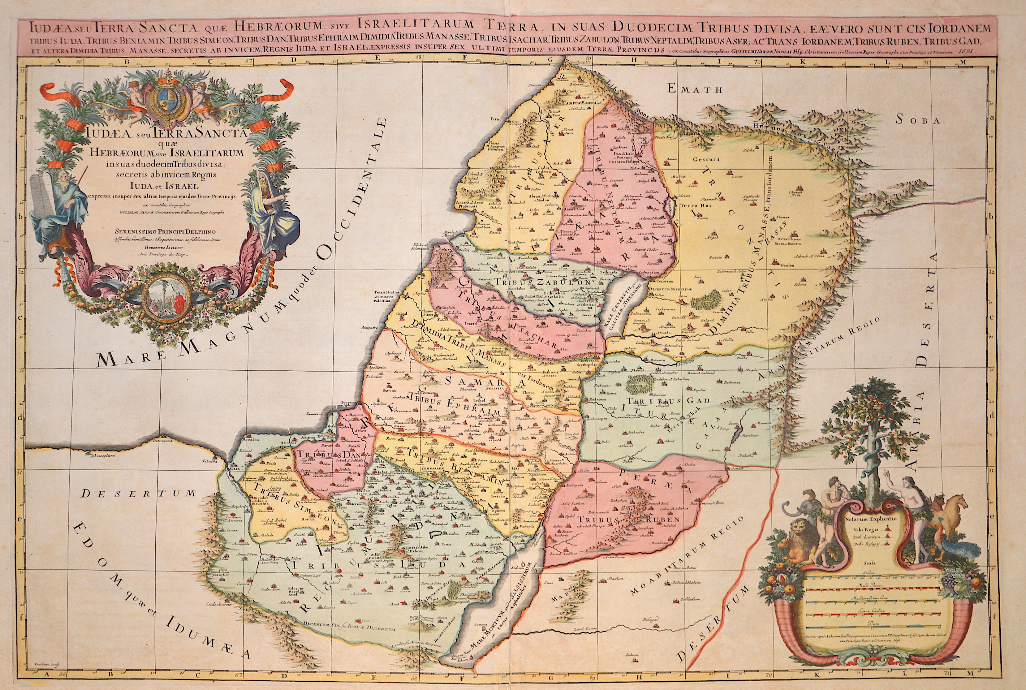
Judaea seu Terra Sancta quae Hebraeorum sive Israelitarum insas duodecim Tribus divisa, secretis ab invicem Regnis Juda, et Israel..

| Article ID | ASP1424 |
Title | Judaea seu Terra Sancta quae Hebraeorum sive Israelitarum insas duodecim Tribus divisa, secretis ab invicem Regnis Juda, et Israel.. |
Description | The map shows the Holy Land (Terra Sancta, the lands of the 12 tribes of Israel). In the top left, a magnificent title cartouche featuring Moses and the tablets of the Ten Commandments. In the center, the royal coat of arms held by two putti. In the bottom right, a splendid milestone cartouche depicting Adam and Eve in the Garden of Eden. |
| Year | c. 1691 |
Artist | Jaillot/ Sanson (1632-1712) |
Alexis Hubert Jaillot (1632–1712) was a prominent French cartographer and publisher. In 1665, he married into the Berey family of map publishers. After the death of his brother-in-law Nicolas II Berey in 1667, Jaillot bought the Berey map collection from his sister-in-law, acquiring a valuable stock without having ever created a map himself. Jaillot entered the map business at a favorable time—after Louis XIV’s early victories in the Reunions Wars in 1668, France’s territory expanded rapidly, creating high demand for maps showing French triumphs, new borders, and expansion plans. His collection included plates originally made by Pierre Duval, who resisted Jaillot’s reissues. At the height of this conflict, Jaillot gained the support of Guillaume and Adrien Sanson, sons of Nicolas Sanson, as mapmakers and partners, enabling him to publish new maps under the prestigious Sanson name. His first atlas, Atlas Nouveau (1681), was a commercial success, leading to widespread piracy by other publishers. | |
Historical Description | The first archaeologically proven traces of an early or proto-Israelite settlement in the Mashrek region go back to the period between the 12th and 11th centuries BC. BC back. According to biblical tradition, Jerusalem was founded around 1000 BC. Conquered by David from the Jebusites and chosen as the capital of his great empire. The country subsequently became part of the Persian Empire, then the Empire of Alexander the Great, and finally the Empire of the Seleucids. The Maccabees revolt in 165 BC BC brought Israel once more state independence for about 100 years. 63 BC The time of Roman supremacy began. The Romans divided the area into two provinces: Syria in the north, Judea in the south. In the course of the Islamic expansion, the area came under Arab rule in 636. Since then, Palestine has been predominantly inhabited by Arabs. The crusaders ruled from 1099 to 1291 what they called the "Latin Kingdom of Jerusalem". This was followed by the Mamluks from 1291 to 1517 and then the Ottoman rule from 1517 to 1918. None of these authorities had planned their own administration for Palestine or viewed the area as an independent geographical unit. The region was also part of Syria for the Ottomans, probably going back to the Roman name Syria. |
| Place of Publication | Paris |
| Dimensions (cm) | 56,5 x 83,5 cm |
| Condition | Little stains |
| Coloring | original colored |
| Technique | Copper print |