

Adina Sommer
Antique and Contemporary Art
Winzerer Str. 154
80797 München
telephone
+49 89 304714
business hours:
by appointment
Email
![]()


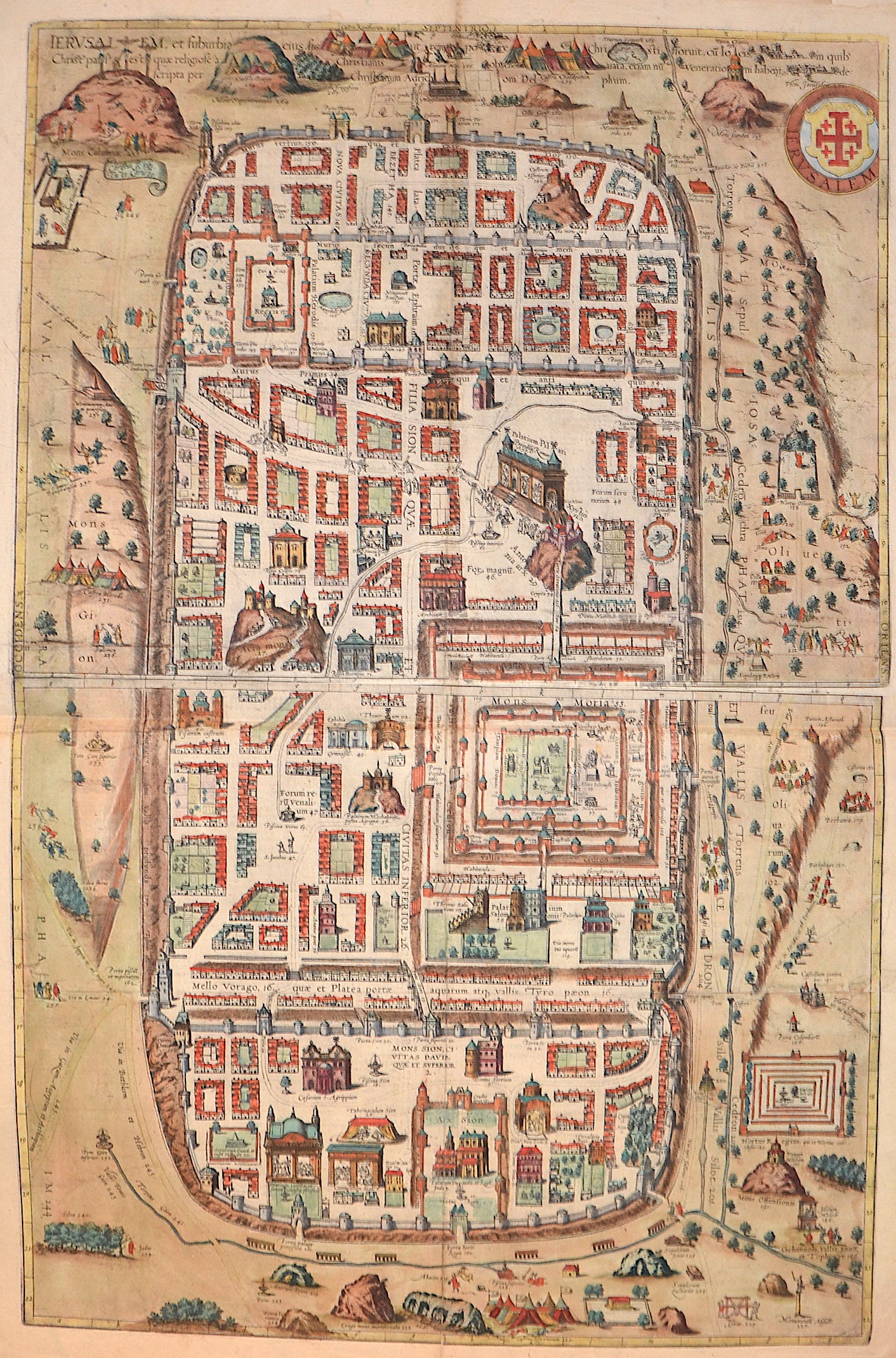
Jerusalem, et suburbiaeius sicut tempore Christi floruit, cu locis, in quib.. / Jerusalem. Von Michael Eyzinger beschriben und illustriert.

| Article ID | ASP1421 |
Title | Jerusalem, et suburbiaeius sicut tempore Christi floruit, cu locis, in quib.. / Jerusalem. Von Michael Eyzinger beschriben und illustriert. |
Description | 2-sheet plan of Jerusalem, based on Christian Van Adrichom's plan of the ancient city of Jerusalem (published in 1584 in Cologne) and its suburbs during the time of Jesus. This map shows over 250 locations and scenes of Jerusalem. It depicts places described in the Bible as well as in other historical and traditional sources. There is no chronological order of the scenes, as ancient scenes and figures are shown alongside European buildings and characters from the sixteenth century. The plan itself is surrounded by many illustrations of biblical and historical interest and includes a dedication to the Archbishop of Cologne. The reverse side features a German description of the city of |
| Year | ca. 1588 |
Artist | Braun/Hogenberg (1572-1618) |
Frans Hogenberg (1535 – 1590) was a Flemish and German painter, engraver, and mapmaker. Hogenberg was born in Mechelen as the son of Nicolaas Hogenberg In 1568 he was banned from Antwerp by the Duke of Alva. He travelled to London, where he stayed a few years before emigrating to Cologne. He is known for portraits and topographical views as well as historical allegories. He also produced scenes of contemporary historical events. George Braun (1541-1622), a cleric of Cologne, was the principal editor of the "Civitates Orbis Terrarum". The first volume of the Civitates Orbis Terrarum was published in Cologne in 1572. The sixth and the final volume appeared in 1617. This great city atlas, edited by Georg Braun and largely engraved by Franz Hogenberg, eventually contained 546 prospects, bird-eye views and map views of cities from all over the world. Braun (1541-1622), a cleric of Cologne, was the principal editor of the work, and was greatly assisted in his project by the close, and continued interest of Abraham Ortelius, whose Theatrum Orbis Terrarum of 1570 was, as a systematic and comprehensive collection of maps of uniform style, the first true atlas. | |
Historical Description | One of the oldest cities in the world, Jerusalem was named as "Urusalima" on ancient Mesopotamian cuneiform tablets, probably meaning "City of Shalem". During its long history, Jerusalem has been destroyed at least twice. The part of Jerusalem called the City of David was settled in the 4th millennium BCEIn 1538, walls were built around Jerusalem under Suleiman the Magnificent. Today those walls define the Old City, which has been traditionally divided into four quarter. There is no evidence of a permanent settlement in the City of David area until the early Bronze Age . Many Jewish tombs from the Second Temple period have been rediscovered in Jerusalem. One example, discovered north of the Old City, contains human remains in an ossuary decorated with the Aramaic inscription "Simon the Temple Builder. In 1517, Jerusalem and environs fell to the Ottoman Turks, who generally remained in control until 1917 .Jerusalem enjoyed a prosperous period of renewal and peace under Suleiman the Magnificent – including the rebuilding of magnificent walls around the Old City. Throughout much of Ottoman rule, Jerusalem remained a provincial, if religiously important center, and did not straddle the main trade route between Damascus and Cairo. The English reference book Modern history or the present state of all nations, written in 1744, stated that "Jerusalem is still reckoned the capital city of Palestine, though much fallen from its ancient grandeaur". The Ottomans brought many innovations: modern postal systems run by the various consulates and regular stagecoach and carriage services were among the first signs of modernization in the city. In the mid 19th century, the Ottomans constructed the first paved road from Jaffa to Jerusalem, and by 1892 the railroad had reached the city. |
| Place of Publication | Cologne |
| Dimensions (cm) | 74 x 47,5 cm |
| Condition | Printed on 2 sheets joined together,centerfolf restored |
| Coloring | original colored |
| Technique | Copper print |