

Adina Sommer
Antique and Contemporary Art
Winzerer Str. 154
80797 München
telephone
+49 89 304714
business hours:
by appointment
Email
![]()


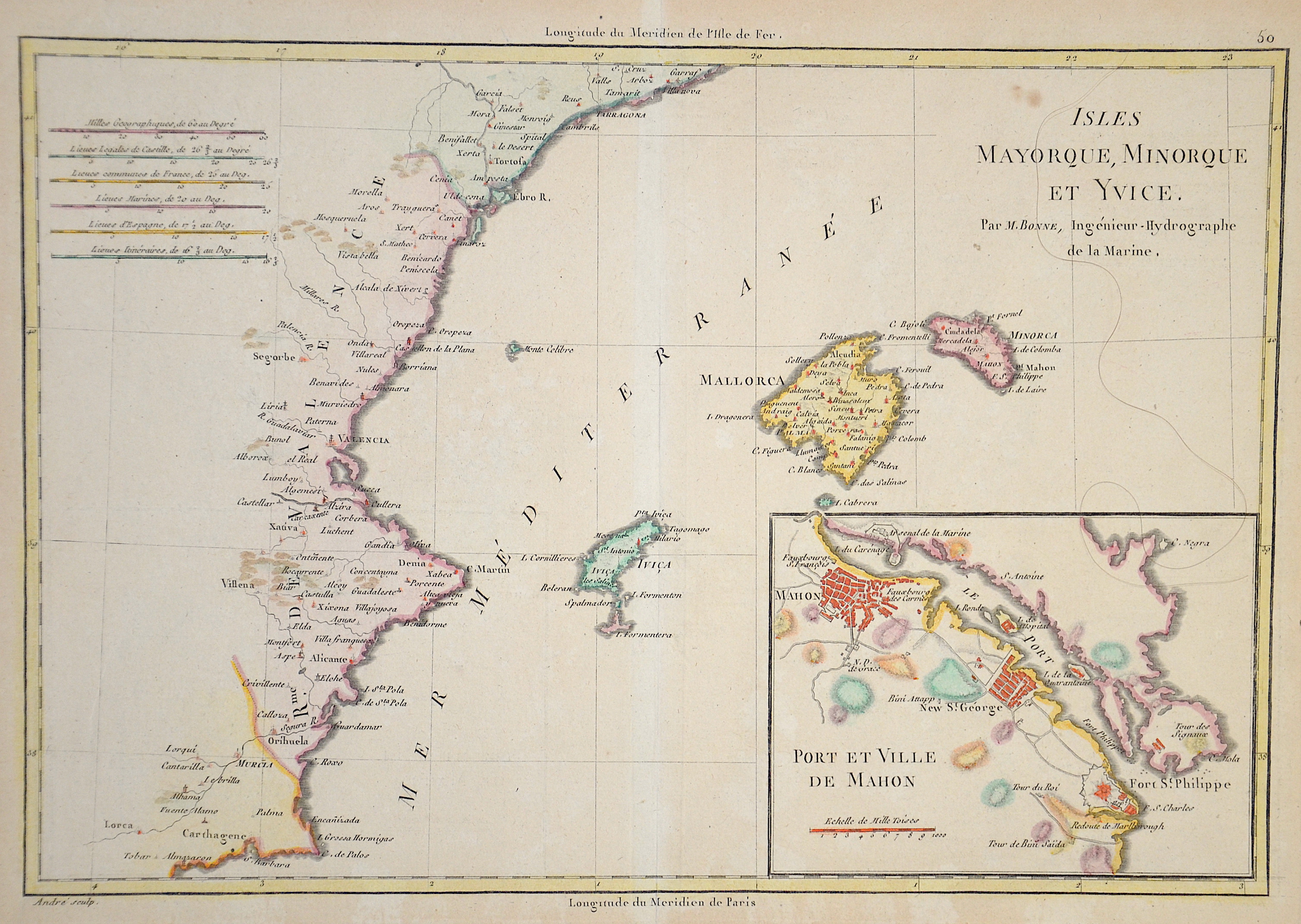
Isles Majorque, Minorque et Yvice

| Article ID | EUE1766 |
Title | Isles Majorque, Minorque et Yvice |
Description | Map shows the coast of Valencia and the islands of Mallorca, Menorca and Ibiza, insert map of Mahon and Port St. Philippe |
| Year | ca. 1720 |
Artist | Fer, de (1646-1720) |
Nicolas de Fer ( 1646 - 1720 in Paris) was a French cartographer and geographer. He also was an engraver and publisher. De Fer was the youngest of three sons of Antoine de Fer, who was also a cartographer. When he was 12, he became the apprentice of Parisian engraver Louis Spirinx, and made his first map, of the Canal du Midi, at the age of 23. After the death of his father in June 1673, de Fer was so successful at improving the firm that, in 1690, he became the official geographer to Louis, Dauphin of France. With support from the Spanish and French Royal Families, de Fer also became official geographer for Philip V and Louis XIV, the kings of Spain and France, respectively. Because of this, his maps became Bourbon propaganda, endorsing French King Louis XIV. His business flourished, producing town plans, atlases, wall maps, and more than 600 sheet maps.He made maps of places in Europe and North America, including New Spain, places fortified by Vauban, the Low Countries, and the War of the Spanish Succession. In 1698, de Fer published a map of North America, which included a depiction of beavers building dams near Niagara Falls. Seventeen years later, Herman Moll published an identical map as his own, known as the -Beaver map-. De Fer became the official geographer for His Catholic Majesty in 1720.Two of his sons-in-law, Guillaume Danet and Jaques-François Bénard, continued the company after de Fer's death on 25 October of that year until around 1760. | |
Historical Description | The indigenous population of the Balearic Islands probably immigrated from the Iberian Peninsula or today's southern France. In ancient times, the islands were called Balearides or Gymnesiae, which meant the islands of Mallorca (Balearis major) and Menorca (Balearis minor). At first they were dependent on the Phoenicians. Mallorca and Ibiza were conquered in 1229 and 1235 respectively by Jacob I of Aragon (Catalan Jaume I), Menorca by his descendant Alfonso III. The Balearic Islands, like Catalonia, now belonged to the Aragon Crown. At times, together with parts of Catalonia, they formed an independent state, the Kingdom of Mallorca, ruled by a branch of the Aragonese royal family. In 1708 Maó was conquered by the British. The Peace of Utrecht (1713), which ended the War of Spanish Succession, gave Menorca to the British Empire. This had to return the island to Spain in the Treaty of Versailles (1783), but remained British until 1802. The Spanish province of the Balearic Islands was founded in 1833. |
| Place of Publication | Paris |
| Dimensions (cm) | 23 x 34 |
| Condition | Very good |
| Coloring | colored |
| Technique | Copper print |