

Adina Sommer
Antique and Contemporary Art
Winzerer Str. 154
80797 München
telephone
+49 89 304714
business hours:
by appointment
Email
![]()


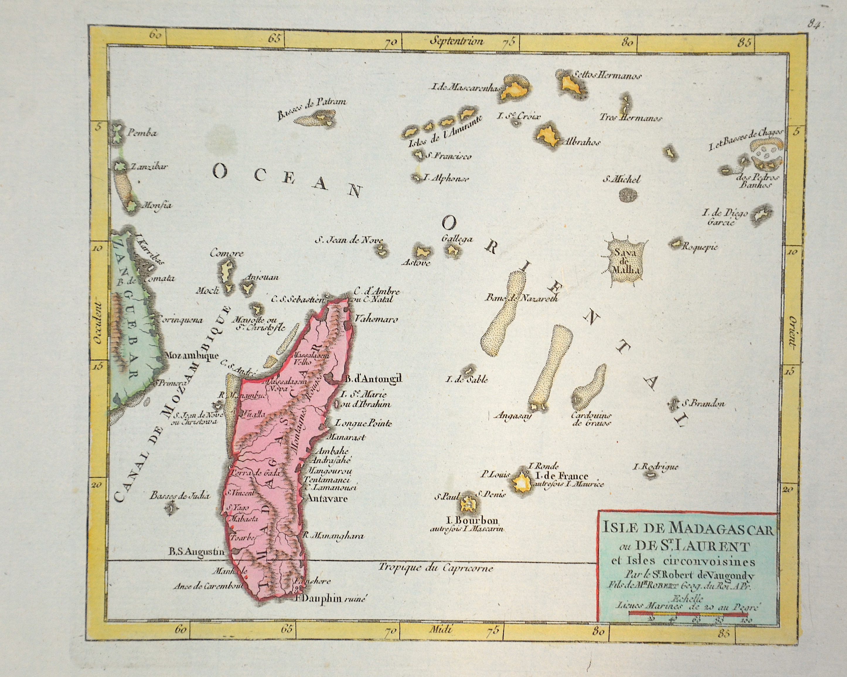
Isle de Madagascar ou de St. Laurent et Isles circonvoisines

| Article ID | AF0479 |
Title | Isle de Madagascar ou de St. Laurent et Isles circonvoisines |
Description | Map shows the island of Madagascar, the island of Reunion (until 1794 the island was called Île Bourbon), Mauritius, the Comoros and the Amirantes (they now belong to the outer islands of the Seychelles). |
| Year | ca. 1760 |
Artist | Vaugondy,de (1723-1786) |
Didier Robert de Vaugondy (1723 -1786) also known as Le Sieur or Monsieur Robert, and his son, were leading cartographers in France during the 18th century. In 1757, Gilles and Didier Robert De Vaugondy published The Atlas Universel, one of the most important atlases of the 18th century. To produce the atlas, the Vaugondys integrated older sources with more modern surveyed maps. They verified and corrected the latitude and longitude of many regional maps in the atlas with astronomical observations. The older material was revised with the addition of many new place names. In 1760, Didier Robert de Vaugondy was appointed geographer to Louis XV. Gilles and Didier Robert De Vaugondy produced their maps and terrestrial globes working together as father and son. Globes of a variety of sizes were made by gluing copperplate-printed gores on a plaster-finished papier-mache core, a complicated and expensive manufacturing process, employing several specialists. In some cases it is uncertain whether Gilles or Didier made a given map. Gilles often signed maps as M.Robert, while Didier commonly signed his maps as ""Robert de Vaugondy"", or added ""fils"" or ""filio"" after his name. The Robert de Vaugondys were descended from the Nicolas Sanson family through Sanson's grandson, Pierre Moulard-Sanson. From him, they inherited much of Sanson's cartographic material, which they combined with maps and plates acquired after Hubert Jaillot's death in 1712 to form the basis the Atlas Universel. | |
Historical Description | Madagascar- officially the Republic of Madagascar , and previously known as the Malagasy Republic, is an island country in the Indian Ocean, off the coast of East Africa. Madagascar was an important transoceanic trading hub connecting ports of the Indian Ocean in the early centuries following human settlement. The written history of Madagascar began with the Arabs, who established trading posts along the northwest coast by at least the 10th century. From about 1774 to 1824, Madagascar gained prominence among pirates and European traders, particularly those involved in the trans-Atlantic slave trade. Many European sailors were shipwrecked on the coasts of the island, among them Robert Drury, whose journal is one of the few written depictions of life in southern Madagascar during the 18th century. The wealth generated by maritime trade spurred the rise of organized kingdoms on the island, some of which had grown quite powerful by the 17th century. Among these were the Betsimisaraka alliance of the eastern coast and the Sakalava chiefdoms of Menabe and Boina on the west coast. The Kingdom of Imerina, located in the central highlands with its capital at the royal palace of Antananarivo, emerged at around the same time under the leadership of King Andriamanelo. |
| Place of Publication | Paris |
| Dimensions (cm) | 16,5 x 19 cm |
| Condition | Perfect condition |
| Coloring | original colored |
| Technique | Copper print |