

Adina Sommer
Antique and Contemporary Art
Winzerer Str. 154
80797 München
telephone
+49 89 304714
business hours:
by appointment
Email
![]()


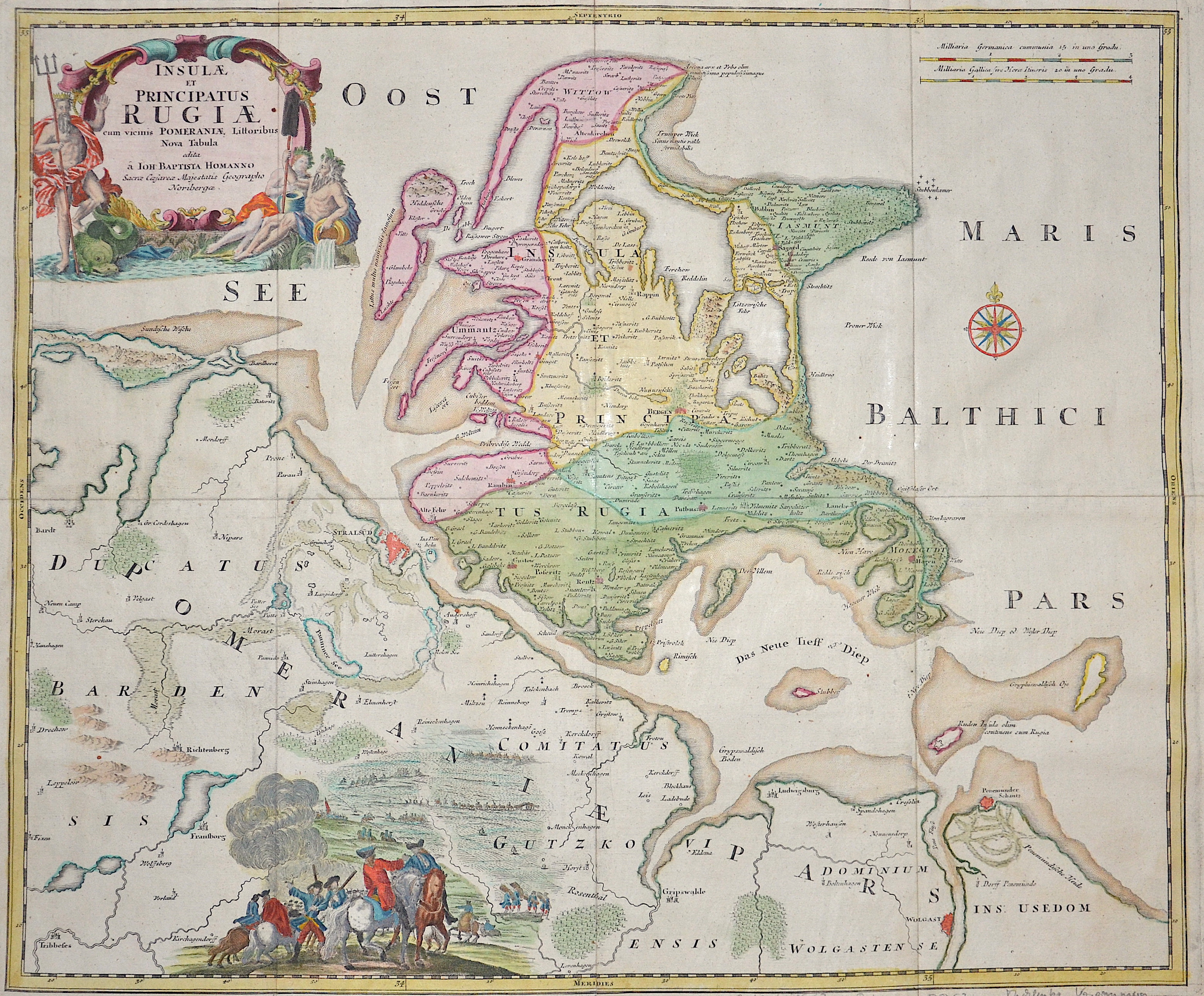
Insule et pricipatus Rugie

| Article ID | EUD520 |
Title | Insule et pricipatus Rugie |
Description | Splendid map showing the island of Rügen with two cartouches and a compass rose. |
| Year | ca. 1710 |
Artist | Homann (1664-1724) |
Johann Babtiste Homann (1664-1724), Nuremberg, was born in Oberkammlach, the Electorate of Bavaria. Although educated at a Jesuit school, and preparing for an ecclesiastical career, he eventually converted to Protestantism and from 1687 worked as a civil law notary in Nuremberg. He soon turned to engraving and cartography; in 1702 he founded his own publishing house. Homann acquired renown as a leading German cartographer, and in 1715 was appointed Imperial Geographer by Emperor Charles VI. Giving such privileges to individuals was an added right that the Holy Roman Emperor enjoyed. In the same year he was also named a member of the Prussian Academy of Sciences in Berlin. Of particular significance to cartography were the imperial printing privileges (Latin: privilegia impressoria). These protected for a time the authors in all scientific fields such as printers, copper engravers, map makers and publishers. They were also very important as a recommendation for potential customers. In 1716 Homann published his masterpiece Grosser Atlas ueber die ganze Welt (Grand Atlas of all the World). Numerous maps were drawn up in cooperation with the engraver Christoph Weigel the Elder, who also published Siebmachers Wappenbuch. Homann died in Nuremberg. He was succeeded by the Homann heirs company, which was in business until 1848. The company was known as Homann Erben, Homanniani Heredes, or Heritiers de Homann abroad. | |
Historical Description | Rügen is Germany's largest island by area. It is located off the Pomeranian coast in the Baltic Sea and belongs to the state of Mecklenburg-Western Pomerania. The island of Rügen is part of the district of Vorpommern-Rügen, with its county seat in Stralsund. The towns on Rügen are: Bergen, Sassnitz, Putbus and Garz. In addition, there are the Baltic seaside resorts of Binz, Baabe, Göhren, Sellin and Thiessow. From the 7th century the West Slavic Rani (or Rujani) built an empire on Rügen and the neighbouring coast between Recknitz and Ryck. It decidedly affected the history of the Baltic Sea area and the surrounding Obodritic and Liutician occupied mainland for the next few centuries. In 1168, the Danish king, Valdemar I, and his army commander and advisor, Bishop Absalon of Roskilde destroyed the Svetovid temple in the hillfort at Cape Arkona, ending both the territorial and religious autonomy of the Rani; their former monarchs became Danish princes of Rügen. Under Danish rule the Principality of Rugia changed its character. Danish monasteries were established. The Slavic cultural element disappeared, mostly due to the lack of their own Slavic church structures, so that the Rani were absorbed in the period that followed into the now German-influenced people of Rügen. After the death of the last Slav prince, Wizlaw III, in 1325, the principality was acquired by Pomerania-Wolgast as a consequence of the 1321 inheritance agreement and from 1372-1451 was part of the estate of a branch line, the House of Barth. In 1478, Pomerania-Wolgast and Pomerania-Stettin were united and, 170 years later, the combined state went to Sweden in 1648 as a result of the Treaty of Westphalia. At the time of Napoleonic Wars, Rügen was held by the French from 1807–1813. In the Treaty of Kiel of 1814, it was transferred initially from Sweden to Denmark and then fell to Prussia, along with New Western Pomerania thanks to the Vienna Convention of 1815. In 1818 the island became part of the administrative district of Stralsund and thus belonged to the Prussian Province of Pomerania. |
| Place of Publication | Nuremberg |
| Dimensions (cm) | 48 x 57 cm |
| Condition | Very good |
| Coloring | original colored |
| Technique | Copper print |